File:The Angus Glens. - geograph.org.uk - 423564.jpg
Jump to navigation
Jump to search
No higher resolution available.
The_Angus_Glens._-_geograph.org.uk_-_423564.jpg (640 × 480 pixels, file size: 46 KB, MIME type: image/jpeg)
Captions
Captions
Add a one-line explanation of what this file represents
Summary
[edit]
| Description |
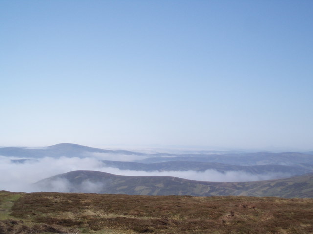
English: The Angus Glens. Taken from Dog Hillock above Glen Moy. Each Glen defined by a channel of cloud, Moy, Clova, Prosen, Isla and beyond into Perthshire. A superb cloud inversion that day unfortunately the bright white, cotton wool carpet above Angus didn't come out well on the camera. And as always, the grey fingers creeping into each of the glens shown above just don't capture what it was actually like. |
| Date | |
| Source | From geograph.org.uk |
| Author | Gwen and James Anderson |
| Attribution (required by the license) | Gwen and James Anderson / The Angus Glens. / |
| Camera location | | View this and other nearby images on: OpenStreetMap |
|---|
_heading:292.00&language=en)
| Object location | | View this and other nearby images on: OpenStreetMap |
|---|
_heading:292.00&language=en)
Licensing
[edit]

|
This image was taken from the Geograph project collection. See this photograph's page on the Geograph website for the photographer's contact details. The copyright on this image is owned by Gwen and James Anderson and is licensed for reuse under the Creative Commons Attribution-ShareAlike 2.0 license.
|
This file is licensed under the Creative Commons Attribution-Share Alike 2.0 Generic license.
Attribution: Gwen and James Anderson
- You are free:
- to share – to copy, distribute and transmit the work
- to remix – to adapt the work
- Under the following conditions:
- attribution – You must give appropriate credit, provide a link to the license, and indicate if changes were made. You may do so in any reasonable manner, but not in any way that suggests the licensor endorses you or your use.
- share alike – If you remix, transform, or build upon the material, you must distribute your contributions under the same or compatible license as the original.
File history
Click on a date/time to view the file as it appeared at that time.
| Date/Time | Thumbnail | Dimensions | User | Comment | |
|---|---|---|---|---|---|
| current | 05:41, 4 February 2011 | | 640 × 480 (46 KB) | GeographBot (talk | contribs) | == {{int:filedesc}} == {{Information |description={{en|1=The Angus Glens. Taken from Dog Hillock above Glen Moy. Each Glen defined by a channel of cloud, Moy, Clova, Prosen, Isla and beyond into Perthshire. A superb cloud inversion that day unfortunately |
You cannot overwrite this file.
File usage on Commons
There are no pages that use this file.