File:The 1716 Treaty's border.jpg
Jump to navigation
Jump to search

Size of this preview: 800 × 600 pixels. Other resolutions: 320 × 240 pixels | 640 × 480 pixels | 1,024 × 768 pixels | 1,280 × 960 pixels | 2,560 × 1,920 pixels | 4,032 × 3,024 pixels.
Original file (4,032 × 3,024 pixels, file size: 3.27 MB, MIME type: image/jpeg)
Captions
Captions
Add a one-line explanation of what this file represents
Summary
[edit]| Description |
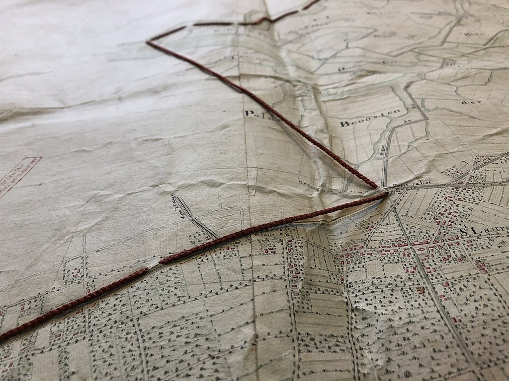
English: Detail of the map that, in 1716, fixed the limits between the Habsburg Low Countries and the United Provinces, following the War of Spanish Succession. This limit is nowadays the border between Belgium and Netherlands. It is indicated on the map by a red thread.
Two copies of the map exist, one at the Nationaal Archief of The Hague and this one at the State Archives in Brussels. The Belgian copy was made in 1758 by R.V. Luchtelen and Colonel De Laing. Transcript of the map's cartouche: Carte particulière des environs d'une partie des limistes en Flandre entre les terres de S.M.I. et Catholicque et celle des Etats Genereaux des Provinces Unies. Faite et levée par Nicolas Suly Capitaine et Ingenieur. Commencé a lever le 15me Fevrier 1716, a Blankenberg, et fini le 30me de May a den Overslacht. Faite a Bruxelles le 26e s[eptem]bre 1716. La ligne d'or marque la vieille limiste.
|
|||
| Date | ||||
| Source | Own work | |||
| Author | Hispalois |


| Camera location | | View this and other nearby images on: OpenStreetMap |
|---|
Licensing
[edit]
I, the copyright holder of this work, hereby publish it under the following license:
This file is licensed under the Creative Commons Attribution-Share Alike 4.0 International license.
- You are free:
- to share – to copy, distribute and transmit the work
- to remix – to adapt the work
- Under the following conditions:
- attribution – You must give appropriate credit, provide a link to the license, and indicate if changes were made. You may do so in any reasonable manner, but not in any way that suggests the licensor endorses you or your use.
- share alike – If you remix, transform, or build upon the material, you must distribute your contributions under the same or compatible license as the original.

|
This image was uploaded as part of the photo contest Wiki Loves Heritage in Belgium in 2021.
|
File history
Click on a date/time to view the file as it appeared at that time.
| Date/Time | Thumbnail | Dimensions | User | Comment | |
|---|---|---|---|---|---|
| current | 07:42, 16 October 2021 | | 4,032 × 3,024 (3.27 MB) | Hispalois (talk | contribs) | Uploaded own work with UploadWizard |
You cannot overwrite this file.
File usage on Commons
There are no pages that use this file.
File usage on other wikis
The following other wikis use this file:
- Usage on ar.wikipedia.org
- Usage on en.wikipedia.org