File:Thassos topographic map blank.svg
Jump to navigation
Jump to search

Size of this PNG preview of this SVG file: 463 × 600 pixels. Other resolutions: 185 × 240 pixels | 370 × 480 pixels | 593 × 768 pixels | 790 × 1,024 pixels | 1,581 × 2,048 pixels | 962 × 1,246 pixels.
Original file (SVG file, nominally 962 × 1,246 pixels, file size: 812 KB)
Captions
Captions
Add a one-line explanation of what this file represents
| Description |
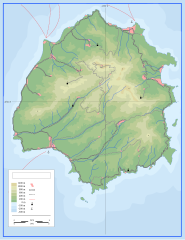
English: Topographic map of island Thasos (blank). Српски / srpski: Топографска карта острва Тасос. Hrvatski: Topografska mapa otoka Tasos. Deutsch: Topographische Karte der Insel Thasos (leer). Italiano: Mappa topografica dell'isola di Taso. Македонски: Kарта на островот Тасос. |
| Date | (UTC) |
| Source | |
| Author |
|
| This is a retouched picture, which means that it has been digitally altered from its original version. Modifications: deleted toponyms and made blank for other uses. The original can be viewed here: Thassos topographic map sr.svg:
|
I, the copyright holder of this work, hereby publish it under the following licenses:
This file is licensed under the Creative Commons Attribution-Share Alike 3.0 Unported license.
- You are free:
- to share – to copy, distribute and transmit the work
- to remix – to adapt the work
- Under the following conditions:
- attribution – You must give appropriate credit, provide a link to the license, and indicate if changes were made. You may do so in any reasonable manner, but not in any way that suggests the licensor endorses you or your use.
- share alike – If you remix, transform, or build upon the material, you must distribute your contributions under the same or compatible license as the original.

|
Permission is granted to copy, distribute and/or modify this document under the terms of the GNU Free Documentation License, Version 1.2 or any later version published by the Free Software Foundation; with no Invariant Sections, no Front-Cover Texts, and no Back-Cover Texts. A copy of the license is included in the section entitled GNU Free Documentation License. |
You may select the license of your choice.
Original upload log
[edit]
This image is a derivative work of the following images:
- File:Thassos_topographic_map_sr.svg licensed with Cc-by-sa-3.0, GFDL
- 2010-10-12T07:37:43Z Ivan25 962x1246 (890761 Bytes) {{Information |Description={{en|1=Topographic map of island Thassos.}} {{sr|1=Топографска карта острва Тасос.}} {{hr|1=Topografska mapa otoka Tasos.}} {{de|1=Topographische Karte der Insel Thassos.}
Uploaded with derivativeFX
File history
Click on a date/time to view the file as it appeared at that time.
| Date/Time | Thumbnail | Dimensions | User | Comment | |
|---|---|---|---|---|---|
| current | 09:06, 20 November 2010 | | 962 × 1,246 (812 KB) | Ivan25 (talk | contribs) | {{Information |Description={{en|1=Topographic map of island Thasos (blank).}} {{sr|1=Топографска карта острва Тасос.}} {{hr|1=Topografska mapa otoka Tasos.}} {{de|1=Topographische Karte der Insel Thasos (leer).}} {{it|1=Mappa to |
You cannot overwrite this file.
File usage on Commons
There are no pages that use this file.