File:Texas (MODIS 2020-05-21).jpg

Original file (5,938 × 4,737 pixels, file size: 3.11 MB, MIME type: image/jpeg)
Captions
Captions
Summary
[edit].jpg&action=edit§ion=1)
| Description |
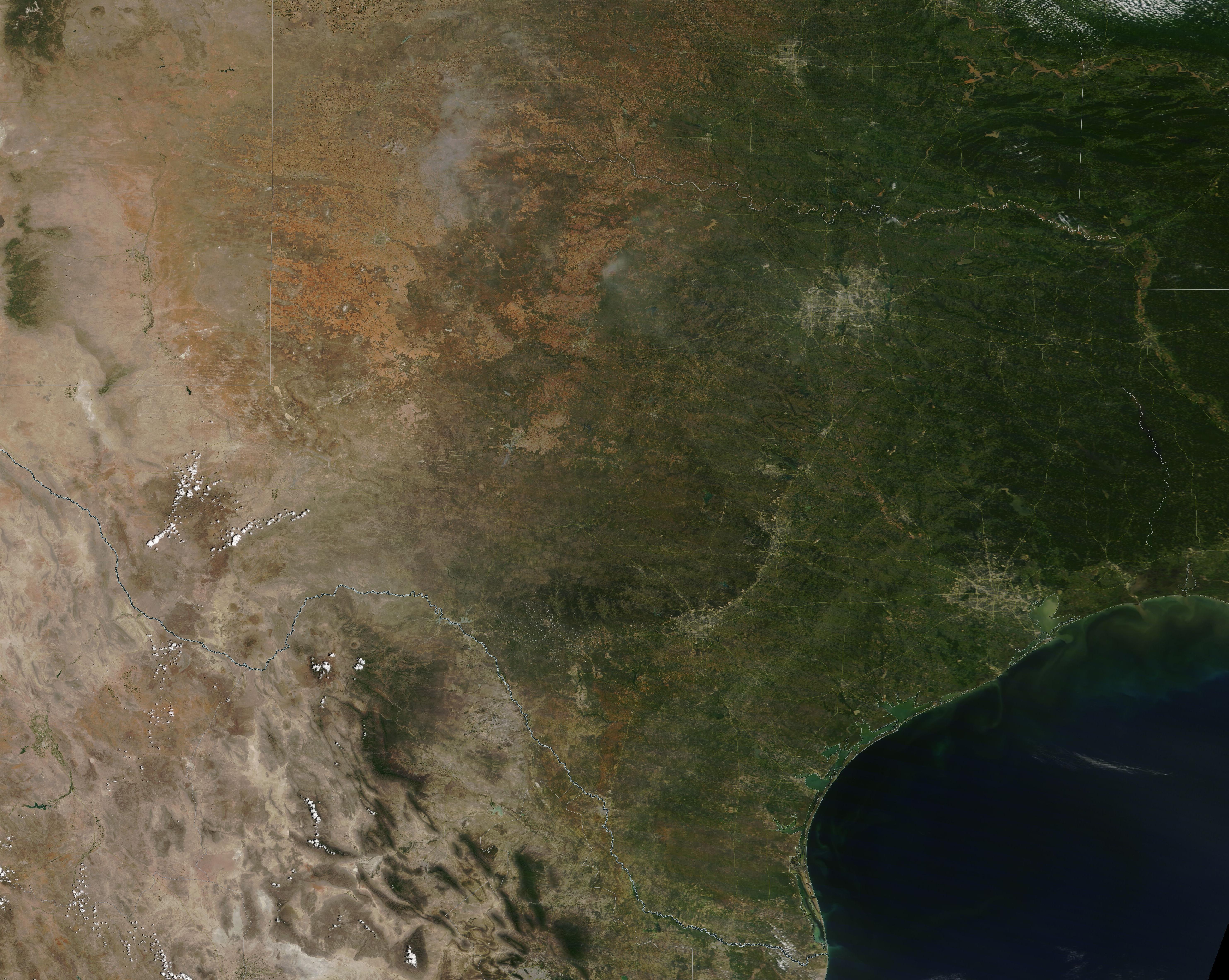
English: On May 18, 2020, the Moderate Resolution Imaging Spectroradiometer (MODIS) on board NASA’s Terra satellite acquired a true-color image of the state of Texas.
Bordered by the states of Oklahoma on the north and northeast, Arkansas, Louisiana, and the Gulf of Mexico in the east, New Mexico in the northwest, and by Mexico in the south Texas stretches over 261,232 square miles (676,587 square kilometers). This brings it in as the second-largest state in the United States following only Alaska. There are four major physical regions in the state: the Gulf Coastal Plains, the Interior Lowlands, the Great Plains, and the Basin and Range Province. The Gulf Coastal Plains border the Gulf of Mexico, extending inland across rolling hills covered with vegetation to the Balcones Escarpment, a geological fault zone several miles wide, which creates balcony-like hills that rise sharply above the coastal plain. The Balcones can be easily seen in the image. The cites of San Antonio and Austin (seen as areas of gray pixels) tucked near the feet of these hills. Austin is located to the northeast of San Antonio. The city of Houston, to the southeast of Austin and near the Gulf of Mexico, also sits on the Gulf Coastal Plain. The Interior Lowlands (also called the North Central Plains) cover the northeastern part of Texas and contain many large ranches as well as the metroplex of Dallas-Fort Worth. This region features rolling grasslands and limestone and has a lower humidity than most of the rest of the state. The Great Plains sit on the west of the North-Central Plain, covering most of the Texas Panhandle, and stretch westward to the Basin and Range region. Flat and generally free of vegetation, the region is arid, with hot summers and cold winters. The only parts of Texas that can be considered mountainous are found in the Basin and Range Province. This region, which lies south of New Mexico and north of the Rio Grande, is home to the Guadalupe Mountains, Big Bend National Park, and the Pecos River. |
||
| Date | Taken on 18 May 2020 | ||
| Source |
|
||
| Author | MODIS Land Rapid Response Team, NASA GSFC |
| This media is a product of the Terra mission Credit and attribution belongs to the mission team, if not already specified in the "author" row |
Licensing
[edit].jpg&action=edit§ion=2)
| This file is in the public domain in the United States because it was solely created by NASA. NASA copyright policy states that "NASA material is not protected by copyright unless noted". (See Template:PD-USGov, NASA copyright policy page or JPL Image Use Policy.) | ||
 |
Warnings:
|
File history
Click on a date/time to view the file as it appeared at that time.
| Date/Time | Thumbnail | Dimensions | User | Comment | |
|---|---|---|---|---|---|
| current | 03:05, 17 February 2024 | | 5,938 × 4,737 (3.11 MB) | OptimusPrimeBot (talk | contribs) | #Spacemedia - Upload of http://modis.gsfc.nasa.gov/gallery/images/image05212020_250m.jpg via Commons:Spacemedia |
You cannot overwrite this file.
File usage on Commons
There are no pages that use this file.
.jpg&oldid=909380672)