File:Tet-Offensive-Map.jpg
Jump to navigation
Jump to search
No higher resolution available.
Tet-Offensive-Map.jpg (330 × 448 pixels, file size: 21 KB, MIME type: image/jpeg)
Captions
Captions
Add a one-line explanation of what this file represents
Summary
[edit]
|
This military map image could be re-created using vector graphics as an SVG file. This has several advantages; see Commons:Media for cleanup for more information. If an SVG form of this image is available, please upload it and afterwards replace this template with
{{vector version available|new image name}}.
It is recommended to name the SVG file “Tet-Offensive-Map.svg”—then the template Vector version available (or Vva) does not need the new image name parameter. |


|
This map has been uploaded by Electionworld from en.wikipedia.org to enable the |
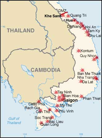
Modified by me from a CIA Factbook map.
Map showing the major targets of the Tet Offensive January-February, 1968
Licensing
[edit]
This image is in the public domain because it contains materials that originally came from the United States Central Intelligence Agency's World Factbook.
|
 |
File history
Click on a date/time to view the file as it appeared at that time.
| Date/Time | Thumbnail | Dimensions | User | Comment | |
|---|---|---|---|---|---|
| current | 21:34, 7 December 2006 | | 330 × 448 (21 KB) | Electionworld (talk | contribs) | {{ew|en|KarlBunker}} Modified by me from a CIA Factbook map. Map showing the major targets of the Tet Offensive January-February, 1968 == Licensing == {{PD-USGov-CIA-WF}} |
You cannot overwrite this file.
File usage on Commons
The following page uses this file:
File usage on other wikis
The following other wikis use this file:
- Usage on ca.wikipedia.org
- Usage on da.wikipedia.org
- Usage on en.wikipedia.org
- Usage on eo.wikipedia.org
- Usage on fi.wikipedia.org
- Usage on fr.wikipedia.org
- Usage on he.wikipedia.org
- Usage on nl.wikipedia.org
- Usage on no.wikipedia.org
- Usage on pl.wikipedia.org
- Usage on pl.wikibooks.org
- Usage on ro.wikipedia.org
- Usage on sh.wikipedia.org
- Usage on simple.wikipedia.org
- Usage on sk.wikipedia.org
- Usage on vi.wikipedia.org