File:Terraced rice-fields Aerial Photograph.jpg
Jump to navigation
Jump to search

Size of this preview: 800 × 581 pixels. Other resolutions: 320 × 232 pixels | 640 × 464 pixels | 1,024 × 743 pixels | 1,280 × 929 pixels | 1,600 × 1,161 pixels.
Original file (1,600 × 1,161 pixels, file size: 1.69 MB, MIME type: image/jpeg)
Captions
Captions
Add a one-line explanation of what this file represents
Summary
[edit]
| Description |
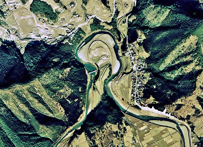
English: terraced rice-fields Aerial Photograph
日本語:あらぎ島の棚田(和歌山県有田川町)の空中写真。ckk-74-9_c31_31を使用。 |
| Date | |
| Source | 国土情報ウェブマッピングシステム |
| Author | 国土交通省 |
Licensing
[edit]

|
The copyright holder of this file, the Ministry of Land, Infrastructure, Transport and Tourism of Japan, allows anyone to use it for any purpose, provided that the copyright holder is properly attributed. Redistribution, derivative work, commercial use, and all other use is permitted. |
Attribution:
Copyright © National Land Image Information (Color Aerial Photographs), Ministry of Land, Infrastructure, Transport and Tourism
|
 |
This image is copyrighted by the Ministry of Land, Infrastructure, Transport and Tourism of Japan. For terms of use, see the stipulation to use of National Land Information (in Japanese) and message from MLIT (in Japanese and English). When you display this image on an article, include the following phrase in the description: "Made based on National Land Image Information (Color Aerial Photographs), Ministry of Land, Infrastructure, Transport and Tourism".
|
File history
Click on a date/time to view the file as it appeared at that time.
| Date/Time | Thumbnail | Dimensions | User | Comment | |
|---|---|---|---|---|---|
| current | 13:50, 17 October 2013 | | 1,600 × 1,161 (1.69 MB) | さかおり (talk | contribs) | Color saturation adjustment and re-trimming |
| 13:57, 6 June 2011 |  | 1,557 × 1,170 (751 KB) | さかおり (talk | contribs) | {{Information |Description ={{en|1=terraced rice-fields Aerial Photograph}} {{ja|1=あらぎ島の棚田(和歌山県有田川町)の空中写真。ckk-74-9_c31_31を使用。}} |Source =国土情報ウェブマッピングシステム |Aut |
You cannot overwrite this file.
File usage on Commons
There are no pages that use this file.
File usage on other wikis
The following other wikis use this file:
- Usage on ja.wikipedia.org