File:Tenbury and Bewdley Railway (Neen Sollars) (geograph 6841252).jpg
Jump to navigation
Jump to search

Size of this preview: 800 × 450 pixels. Other resolutions: 320 × 180 pixels | 640 × 360 pixels | 1,024 × 576 pixels | 1,280 × 720 pixels | 2,560 × 1,440 pixels.
Original file (2,560 × 1,440 pixels, file size: 1.76 MB, MIME type: image/jpeg)
Captions
Captions
Add a one-line explanation of what this file represents
Summary
[edit]_(geograph_6841252).jpg&action=edit§ion=1)
| Description |
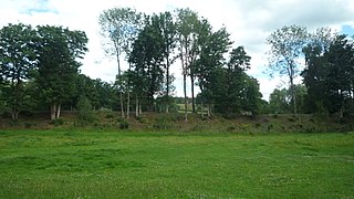
English: Tenbury and Bewdley Railway (Neen Sollars) Neen Sollars had a railway station on this former railway line that operated for 101 years (1864-1965). The railway station and embankment is well-preserved in Neen Sollars. |
| Date | |
| Source | From geograph.org.uk |
| Author | Fabian Musto |
| Permission (Reusing this file) |
Creative Commons Attribution Share-alike license 2.0 |
| Attribution (required by the license) | Fabian Musto / Tenbury and Bewdley Railway (Neen Sollars) / |
| Camera location | | View this and other nearby images on: OpenStreetMap |
|---|
_(geograph_6841252).jpg¶ms=052.348084_N_-002.497030_E_globe:Earth_type:camera_source:geograph-osgb36(SO66247234)_heading:135.00&language=en)
| Object location | | View this and other nearby images on: OpenStreetMap |
|---|
_(geograph_6841252).jpg¶ms=052.347990_N_-002.496880_E_globe:Earth_class:object_type:object_source:geograph-osgb36(SO66257233)_heading:135.00&language=en)
Licensing
[edit]_(geograph_6841252).jpg&action=edit§ion=2)

|
This image was taken from the Geograph project collection. See this photograph's page on the Geograph website for the photographer's contact details. The copyright on this image is owned by Fabian Musto and is licensed for reuse under the Creative Commons Attribution-ShareAlike 2.0 license.
|
This file is licensed under the Creative Commons Attribution-Share Alike 2.0 Generic license.
Attribution: Fabian Musto
- You are free:
- to share – to copy, distribute and transmit the work
- to remix – to adapt the work
- Under the following conditions:
- attribution – You must give appropriate credit, provide a link to the license, and indicate if changes were made. You may do so in any reasonable manner, but not in any way that suggests the licensor endorses you or your use.
- share alike – If you remix, transform, or build upon the material, you must distribute your contributions under the same or compatible license as the original.
File history
Click on a date/time to view the file as it appeared at that time.
| Date/Time | Thumbnail | Dimensions | User | Comment | |
|---|---|---|---|---|---|
| current | 09:55, 21 November 2021 | | 2,560 × 1,440 (1.76 MB) | Lamberhurst (talk | contribs) | == {{int:filedesc}} == {{Information |Description={{en|1=<b>Tenbury and Bewdley Railway (Neen Sollars)</b><br>Neen Sollars had a railway station on this former railway line that operated for 101 years (1864-1965). The railway station and embankment is well-preserved in Neen Sollars.}} |Source=From [https://www.geograph.org.uk/photo/6841252 geograph.org.uk] |Date=2020-07-11 |Author=[https://www.geograph.org.uk/profile/125723 Fabian Musto] |Permission=Creative Commons Attribution Share-alike li... |
You cannot overwrite this file.
File usage on Commons
The following page uses this file:
File usage on other wikis
The following other wikis use this file:
- Usage on en.wikipedia.org
_(geograph_6841252).jpg&oldid=936507737)