File:Temoe Map Names.png
Jump to navigation
Jump to search
Size of this preview: 800 × 582 pixels. Other resolutions: 320 × 233 pixels | 640 × 466 pixels | 1,024 × 745 pixels | 1,240 × 902 pixels.
Original file (1,240 × 902 pixels, file size: 237 KB, MIME type: image/png)
Captions
Captions
Add a one-line explanation of what this file represents

|
This map image could be re-created using vector graphics as an SVG file. This has several advantages; see Commons:Media for cleanup for more information. If an SVG form of this image is available, please upload it and afterwards replace this template with
{{vector version available|new image name}}.
It is recommended to name the SVG file “Temoe Map Names.svg”—then the template Vector version available (or Vva) does not need the new image name parameter. |
Summary
[edit]
| Description |
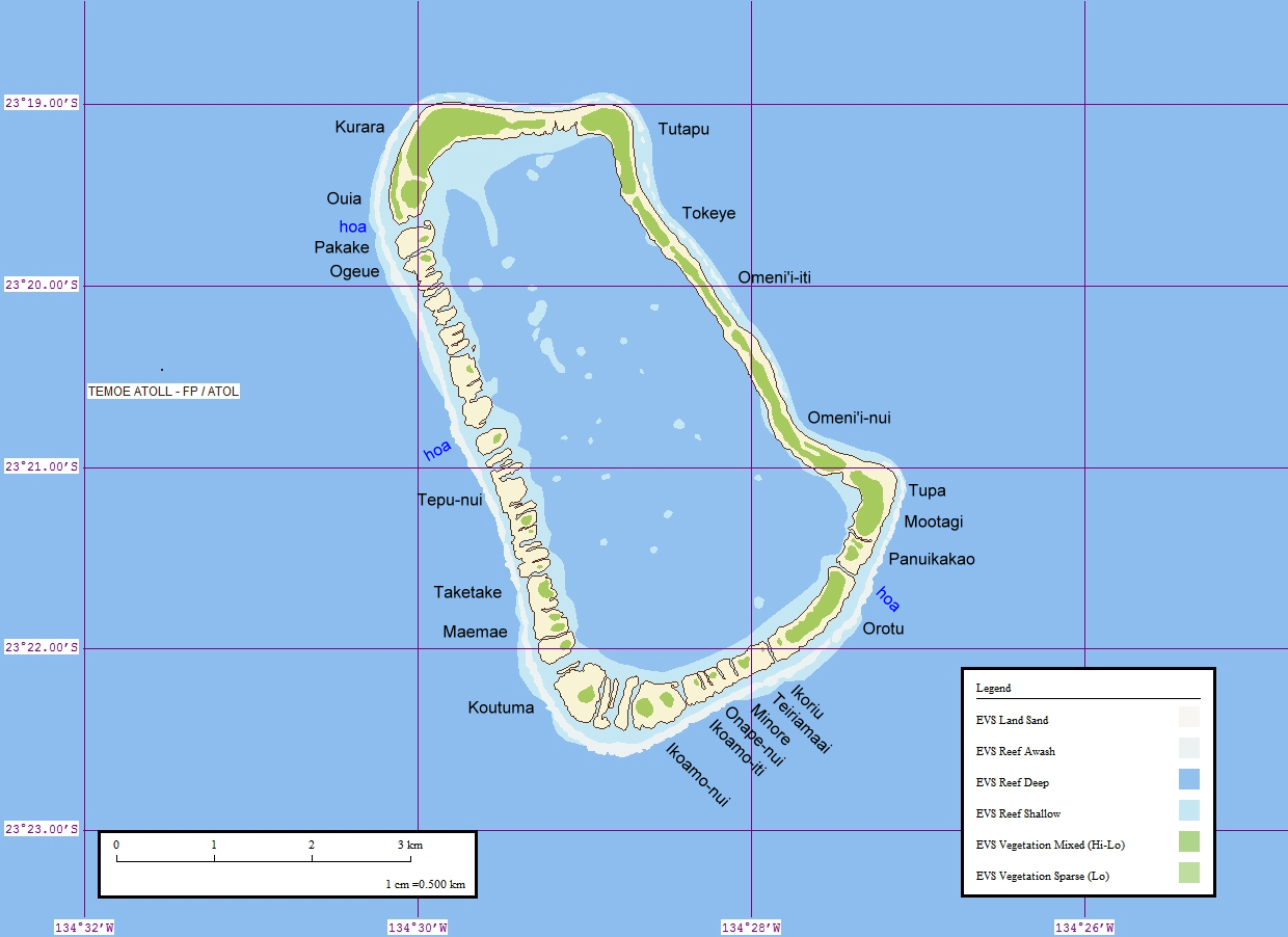
English: Map of Temoe Atoll, Gambier Islands, French Polynesia |
| Date | (UTC) |
| Source |
This file was derived from: Temoe Map.jpg: |
| Author |
|
| This is a retouched picture, which means that it has been digitally altered from its original version. Modifications: added names of islets (motus) and sections of islets. The original can be viewed here: Temoe Map.jpg:
|
Licensing
[edit]
I, the copyright holder of this work, hereby publish it under the following license:
This file is licensed under the Creative Commons Attribution 2.0 Generic license.
- You are free:
- to share – to copy, distribute and transmit the work
- to remix – to adapt the work
- Under the following conditions:
- attribution – You must give appropriate credit, provide a link to the license, and indicate if changes were made. You may do so in any reasonable manner, but not in any way that suggests the licensor endorses you or your use.
Original upload log
[edit]
This image is a derivative work of the following images:
- File:Temoe_Map.jpg licensed with Cc-by-2.0
- 2008-05-02T07:58:09Z Telim tor 1240x902 (205109 Bytes) == Information == {{Information |Description=Map of Temoe Atoll, Tuamotu Archipelago, French Polynesia |Source=[http://www.flickr.com/photos/evsmap/sets/72157594235280883/ Flickr] |Date=13 August 2006 |Author=[http://www.flic
Uploaded with derivativeFX
File history
Click on a date/time to view the file as it appeared at that time.
| Date/Time | Thumbnail | Dimensions | User | Comment | |
|---|---|---|---|---|---|
| current | 16:41, 3 October 2012 | | 1,240 × 902 (237 KB) | Ratzer (talk | contribs) | added "hoa" |
| 16:00, 3 October 2012 |  | 1,240 × 902 (236 KB) | Ratzer (talk | contribs) | == {{int:filedesc}} == {{Information |Description={{en|Map of Temoe Atoll, Gambier Islands, French Polynesia}} |Source={{Derived from|Temoe_Map.jpg|display=50}} |Date=2012-10-03 15:56 (UTC) |Author=*File:Temoe_Map.jpg: [http://www.flickr.com/phot... |
You cannot overwrite this file.
File usage on Commons
There are no pages that use this file.
File usage on other wikis
The following other wikis use this file: