File:Tel Nof Airbase Map.png
Jump to navigation
Jump to search

Size of this preview: 800 × 595 pixels. Other resolutions: 320 × 238 pixels | 640 × 476 pixels | 1,024 × 762 pixels | 1,280 × 952 pixels | 2,720 × 2,024 pixels.
Original file (2,720 × 2,024 pixels, file size: 3.59 MB, MIME type: image/png)
Captions
Captions
Add a one-line explanation of what this file represents
| Description |
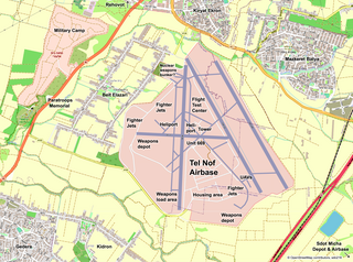
Deutsch: Karte des israelischen Militärflugplatzes Tel Nof English: Map of Israel Air Force Base Tel Nof |
|||
| Date | ||||
| Source | openstreetmap.org | |||
| Creator |
OpenStreetMap contributors, sdo216 OpenStreetMap contributors |
|||
| Permission (Reusing this file) |
OpenStreetMap data is available under the Open Database License (details). Standard style map tiles are licensed as ODbL Produced Works.
|
|||
| Georeferencing | If inappropriate please set warp_status = skip to hide. |
File history
Click on a date/time to view the file as it appeared at that time.
| Date/Time | Thumbnail | Dimensions | User | Comment | |
|---|---|---|---|---|---|
| current | 14:50, 5 April 2024 | | 2,720 × 2,024 (3.59 MB) | Sdo216 (talk | contribs) | No HQ |
| 14:06, 20 January 2024 |  | 2,720 × 2,024 (3.6 MB) | Sdo216 (talk | contribs) | More details | |
| 14:23, 7 January 2024 |  | 2,720 × 2,024 (3.59 MB) | Sdo216 (talk | contribs) | Corrections | |
| 19:06, 3 January 2024 |  | 2,720 × 2,024 (3.57 MB) | Sdo216 (talk | contribs) | Corrections | |
| 15:08, 3 January 2024 |  | 2,720 × 2,024 (3.55 MB) | Sdo216 (talk | contribs) | More details | |
| 16:29, 16 October 2023 |  | 2,720 × 2,024 (3.5 MB) | Sdo216 (talk | contribs) | More details | |
| 09:54, 16 October 2023 |  | 2,720 × 2,024 (3.5 MB) | Sdo216 (talk | contribs) | UAVs | |
| 08:47, 16 October 2023 |  | 2,720 × 2,024 (3.49 MB) | Sdo216 (talk | contribs) | More details | |
| 15:20, 10 October 2023 |  | 2,720 × 2,024 (3.47 MB) | Sdo216 (talk | contribs) | Some corrections | |
| 14:10, 10 October 2023 |  | 2,720 × 2,024 (3.47 MB) | Sdo216 (talk | contribs) | More contrast and details |
You cannot overwrite this file.
File usage on Commons
The following 6 pages use this file:
File usage on other wikis
The following other wikis use this file:
- Usage on en.wikipedia.org