File:Tavener-Sears Tavern site.jpg
Original file (6,016 × 4,000 pixels, file size: 6.32 MB, MIME type: image/jpeg)
Captions
This is an image of a place or building that is listed on the National Register of Historic Places in the United States of America. Its reference number is 82003621. |
Camera location | 39° 57′ 25″ N, 82° 09′ 02″ W | View this and other nearby images on: OpenStreetMap | 39.956944; -82.150556 |
---|
DescriptionTavener-Sears Tavern site.jpg |
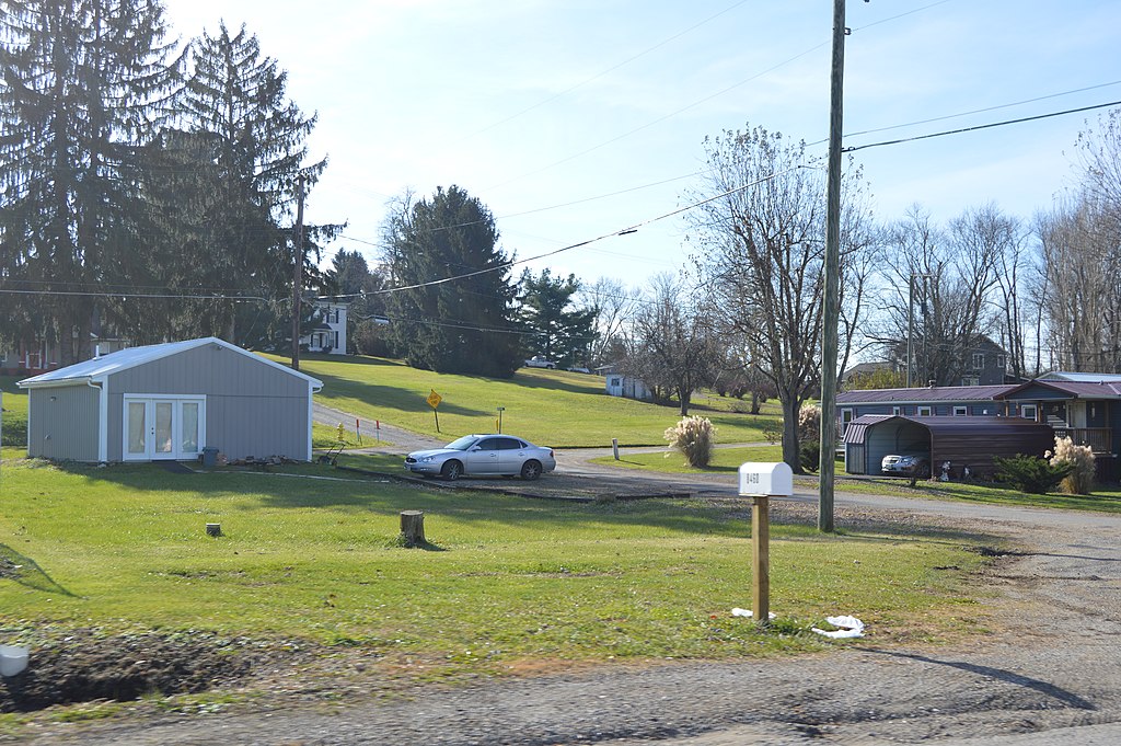
English: Overview of the site of the Tavener-Sears Tavern, which formerly sat on Main Street at Mount Sterling in Hopewell Township, Muskingum County, Ohio, United States. It was listed on the National Register of Historic Places in 1982, and despite its removal, it officially remains on the Register. |
|||
Date | Taken on 27 November 2017 | |||
Source | Own work | |||
Author | Nyttend | |||
Permission (Reusing this file) |
|
|||
Other versions | None |
File history
Click on a date/time to view the file as it appeared at that time.
Date/Time | Thumbnail | Dimensions | User | Comment | |
---|---|---|---|---|---|
current | 00:39, 7 December 2017 | 6,016 × 4,000 (6.32 MB) | Nyttend (talk | contribs) | {{NRHP|82003621}} {{Location|39|57|25|N|82|9|2|W}} {{Information |Description={{en|Overview of the site of the {{w|Tavener-Sears Tavern}}, which formerly sat on Main Street at {{w|Mount Sterling, Muskingum County, Ohio|Mount Sterling}} in {{w|Hopewell... |
You cannot overwrite this file.
File usage on Commons
The following page uses this file:
File usage on other wikis
The following other wikis use this file:
- Usage on en.wikipedia.org
Metadata
This file contains additional information such as Exif metadata which may have been added by the digital camera, scanner, or software program used to create or digitize it. If the file has been modified from its original state, some details such as the timestamp may not fully reflect those of the original file. The timestamp is only as accurate as the clock in the camera, and it may be completely wrong.
Camera manufacturer | NIKON CORPORATION |
---|---|
Camera model | NIKON D3200 |
Exposure time | 1/250 sec (0.004) |
F-number | f/8 |
ISO speed rating | 100 |
Date and time of data generation | 11:32, 27 November 2017 |
Lens focal length | 28 mm |
Orientation | Normal |
Horizontal resolution | 300 dpi |
Vertical resolution | 300 dpi |
Software used | Ver.1.03 |
File change date and time | 11:32, 27 November 2017 |
Y and C positioning | Co-sited |
Exposure Program | Not defined |
Exif version | 2.3 |
Date and time of digitizing | 11:32, 27 November 2017 |
Meaning of each component |
|
Image compression mode | 2 |
APEX exposure bias | 0 |
Maximum land aperture | 4 APEX (f/4) |
Metering mode | Pattern |
Light source | Unknown |
Flash | Flash did not fire, compulsory flash suppression |
DateTime subseconds | 50 |
DateTimeOriginal subseconds | 50 |
DateTimeDigitized subseconds | 50 |
Supported Flashpix version | 1 |
Color space | sRGB |
Sensing method | One-chip color area sensor |
File source | Digital still camera |
Scene type | A directly photographed image |
Custom image processing | Normal process |
Exposure mode | Auto exposure |
White balance | Auto white balance |
Digital zoom ratio | 1 |
Focal length in 35 mm film | 42 mm |
Scene capture type | Standard |
Scene control | None |
Contrast | Normal |
Saturation | Normal |
Sharpness | Normal |
Subject distance range | Unknown |
GPS tag version | 2.3.0.0 |
Structured data
Items portrayed in this file
depicts
27 November 2017
39°57'24.998"N, 82°9'2.002"W
0.004 second
28 millimetre
100
image/jpeg
- National Register of Historic Places with known IDs
- National Register of Historic Places missing SDC depicts
- National Register of Historic Places missing SDC location of creation
- Files with coordinates missing SDC location of creation
- United States photographs taken on 2017-11-27
- Self-published work
- PD-self
- Community pictures by User:Nyttend