File:Taulard où dormaient les prisonniers.jpg
Jump to navigation
Jump to search

Size of this preview: 800 × 533 pixels. Other resolutions: 320 × 213 pixels | 640 × 427 pixels | 1,024 × 683 pixels | 1,280 × 853 pixels | 1,650 × 1,100 pixels.
Original file (1,650 × 1,100 pixels, file size: 1.43 MB, MIME type: image/jpeg)
Captions
Captions
Add a one-line explanation of what this file represents
Summary
[edit]
| Description |
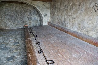
Français : Ce grand "banc" en bois (aussi appelé "taulard") était l'emplacement où dormaient les détenus. Ils étaient enchainés par les pieds à un axe en métal traversant tout le banc.
Une vingtaine de détenus pouvaient dormir côte à côte sur un banc comme celui-ci. Ce meuble est une reconstitution de la prison coloniale de la forteresse de Louisbourg, en Nouvelle France, au début du XVIIIème siècle. On retrouvait des aménagements du même type dans les bagnes de France (Brest, Toulon, Rochefort...). |
| Date | |
| Source | Own work |
| Author | Erming Gwenn |
| Camera location | | View this and other nearby images on: OpenStreetMap |
|---|
Ancienne prison reconstituée, Bâtiment principale de la Forteresse de Louisbourg, Ile du Cap Breton, Nouvelle Ecosse, Canada.
Licensing
[edit]
I, the copyright holder of this work, hereby publish it under the following license:
This file is licensed under the Creative Commons Attribution-Share Alike 4.0 International license.
- You are free:
- to share – to copy, distribute and transmit the work
- to remix – to adapt the work
- Under the following conditions:
- attribution – You must give appropriate credit, provide a link to the license, and indicate if changes were made. You may do so in any reasonable manner, but not in any way that suggests the licensor endorses you or your use.
- share alike – If you remix, transform, or build upon the material, you must distribute your contributions under the same or compatible license as the original.
File history
Click on a date/time to view the file as it appeared at that time.
| Date/Time | Thumbnail | Dimensions | User | Comment | |
|---|---|---|---|---|---|
| current | 15:03, 6 September 2016 | | 1,650 × 1,100 (1.43 MB) | Evalois (talk | contribs) | User created page with UploadWizard |
You cannot overwrite this file.
File usage on Commons
There are no pages that use this file.
File usage on other wikis
The following other wikis use this file:
- Usage on fr.wikipedia.org