File:Tarutyne Raion Flag.svg
Jump to navigation
Jump to search

Size of this PNG preview of this SVG file: 493 × 329 pixels. Other resolutions: 320 × 214 pixels | 640 × 427 pixels | 1,024 × 683 pixels | 1,280 × 854 pixels | 2,560 × 1,708 pixels.
Original file (SVG file, nominally 493 × 329 pixels, file size: 32 KB)
Captions
Captions
Add a one-line explanation of what this file represents
Summary
[edit]
| Description |
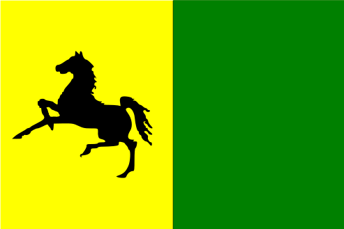
Українська: Прапор Тарутинського районну |
| Date | |
| Source | http://www.vexillographia.ru/ukraine/towns/tarutin.htm |
| Author | Гречило А.Б., Позняков А.А, Яричук П.В. |
Licensing
[edit]
This English translation of the template is outdated. Please update it from the latest українська version, and remove the {{Outdated translation}} tag after the update.
If there is any inconsistency between English translation and other ones, the latest українська version takes precedence.
If there is any inconsistency between English translation and other ones, the latest українська version takes precedence.
According to the Article 10 of the Law of Ukraine on Copyright and Related rights this work is in the public domain within Ukraine and possibly in other jurisdictions because it is one of the following:
|
 |

|
This image shows a flag, a coat of arms, a seal or some other official insignia. The use of such symbols is restricted in many countries. These restrictions are independent of the copyright status. |
File history
Click on a date/time to view the file as it appeared at that time.
| Date/Time | Thumbnail | Dimensions | User | Comment | |
|---|---|---|---|---|---|
| current | 20:02, 25 July 2014 | | 493 × 329 (32 KB) | Ykvach (talk | contribs) | Better version |
| 19:48, 25 July 2014 |  | 493 × 329 (5 KB) | Ykvach (talk | contribs) | User created page with UploadWizard |
You cannot overwrite this file.
File usage on Commons
The following 3 pages use this file:
File usage on other wikis
The following other wikis use this file:
- Usage on ar.wikipedia.org
- Usage on be-tarask.wikipedia.org
- Usage on be.wikipedia.org
- Usage on bg.wikipedia.org
- Usage on crh.wikipedia.org
- Usage on cs.wikipedia.org
- Usage on en.wikipedia.org
- Usage on et.wikipedia.org
- Usage on fr.wikipedia.org
- Usage on hy.wikipedia.org
- Usage on it.wikipedia.org
- Usage on ka.wikipedia.org
- Usage on pl.wikipedia.org
- Usage on ro.wikipedia.org
- Usage on ru.wikipedia.org
- Usage on uk.wikipedia.org
- Одеська область
- Тарутинський район
- Алфавітний покажчик населених пунктів України, які були перейменовані
- Соборне (селище)
- Вікіпедія:Шаблони/Навігаційні/Географія/Україна/Одеська область
- Буджак (Україна)
- Весела Долина (Болградський район)
- Красне (Болградський район)
- Прикордонне (Болградський район)
- Ярославове
- Лужанка (село)
- Серпневе (селище)
- Новоселівка (Бородінська селищна громада)
- Бессарабське
- Підгірне (Тарутинська селищна громада)
- Шаблон:Тарутинський район
- Благодатне (Болградський район)
- Богданівка (Болградський район)
- Булатівка
- Виноградівка (Тарутинська селищна громада)
- Височанське
- Вільне (Болградський район)
- Вознесенка Друга
- Володимирівка (Болградський район)
- Ганнівка (Височанський старостинський округ)
View more global usage of this file.