File:Tarring Neville - geograph.org.uk - 123530.jpg
Jump to navigation
Jump to search
No higher resolution available.
Tarring_Neville_-_geograph.org.uk_-_123530.jpg (640 × 479 pixels, file size: 199 KB, MIME type: image/jpeg)
Captions
Captions
Add a one-line explanation of what this file represents
Summary
[edit]
| Description |
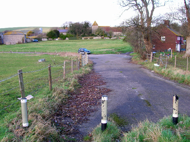
English: Tarring Neville. Tarring Neville is a deserted village containing one church, two farms and a few cottages. In the Domesday Book the village was worth £8.00 considerably more than other villages in the area and made its money from shpbuilding, fishing, salt and agriculture. The village is believed to have been decimated by the fluctuating fortunes of the River Ouse and the Black Death in 1348-50. This view looks north following the old main road which has now been turned into a dead end. |
| Date | |
| Source | From geograph.org.uk |
| Author | Simon Carey |
| Attribution (required by the license) | Simon Carey / Tarring Neville / |
| Camera location | | View this and other nearby images on: OpenStreetMap |
|---|
_&language=en)
| Object location | | View this and other nearby images on: OpenStreetMap |
|---|
_&language=en)
Licensing
[edit]

|
This image was taken from the Geograph project collection. See this photograph's page on the Geograph website for the photographer's contact details. The copyright on this image is owned by Simon Carey and is licensed for reuse under the Creative Commons Attribution-ShareAlike 2.0 license.
|
This file is licensed under the Creative Commons Attribution-Share Alike 2.0 Generic license.
Attribution: Simon Carey
- You are free:
- to share – to copy, distribute and transmit the work
- to remix – to adapt the work
- Under the following conditions:
- attribution – You must give appropriate credit, provide a link to the license, and indicate if changes were made. You may do so in any reasonable manner, but not in any way that suggests the licensor endorses you or your use.
- share alike – If you remix, transform, or build upon the material, you must distribute your contributions under the same or compatible license as the original.
File history
Click on a date/time to view the file as it appeared at that time.
| Date/Time | Thumbnail | Dimensions | User | Comment | |
|---|---|---|---|---|---|
| current | 04:58, 31 January 2010 | | 640 × 479 (199 KB) | GeographBot (talk | contribs) | == {{int:filedesc}} == {{Information |description={{en|1=Tarring Neville. Tarring Neville is a deserted village containing one church, two farms and a few cottages. In the Domesday Book the village was worth £8.00 considerably more than other villages in |
You cannot overwrite this file.
File usage on Commons
There are no pages that use this file.