File:Tanzania map-ru.svg
Jump to navigation
Jump to search

Size of this PNG preview of this SVG file: 596 × 599 pixels. Other resolutions: 239 × 240 pixels | 477 × 480 pixels | 764 × 768 pixels | 1,019 × 1,024 pixels | 2,037 × 2,048 pixels | 2,064 × 2,075 pixels.
Original file (SVG file, nominally 2,064 × 2,075 pixels, file size: 3.19 MB)
Captions
Captions
Add a one-line explanation of what this file represents
Summary
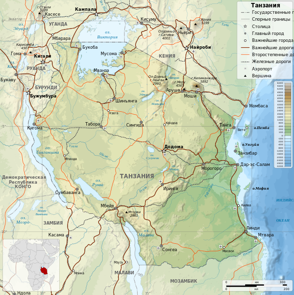
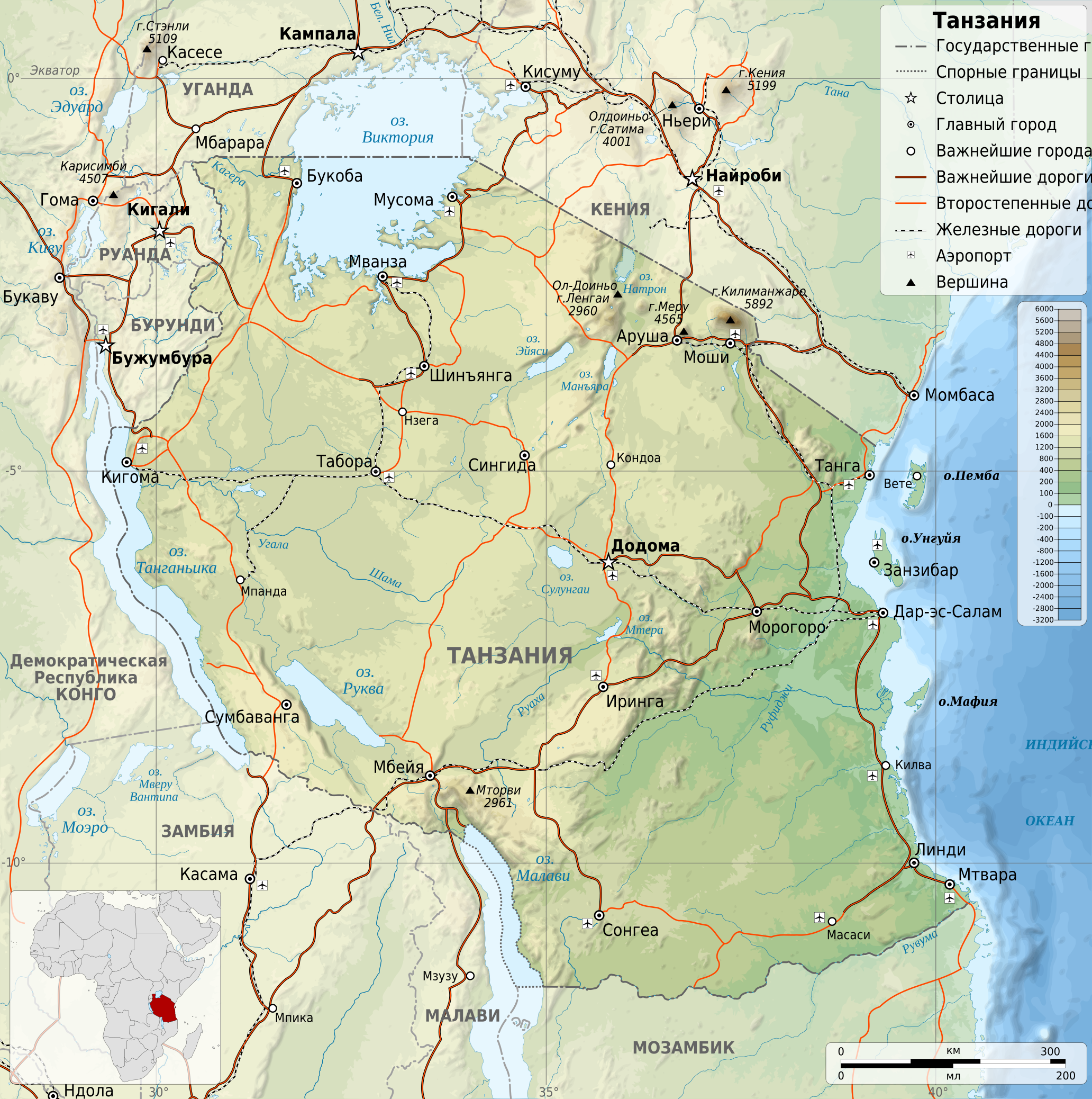
[edit]| Description | Equirectangular projection. 1° N, 28° W, 42° E, -13° S. |
| Date | |
| Source |
travail personnel (own work). Sources of data:
|
| Author | Sémhur, russification by pauk |
| Permission (Reusing this file) |
Attribution and Share-Alike required: any use of this picture can be made as long as you credit me (Wikimedia Commons user: Sémhur) as the creator and distribute the copies and derivative works under the same license that the one indicated below. |
| Other versions |
[]
|


| Object location | | View this and other nearby images on: OpenStreetMap |
|---|

|
This SVG file contains embedded text that can be translated into your language, using any capable SVG editor, text editor or the SVG Translate tool. For more information see: About translating SVG files. |
Licensing
[edit]
I, the copyright holder of this work, hereby publish it under the following licenses:

|
Permission is granted to copy, distribute and/or modify this document under the terms of the GNU Free Documentation License, Version 1.2 or any later version published by the Free Software Foundation; with no Invariant Sections, no Front-Cover Texts, and no Back-Cover Texts. A copy of the license is included in the section entitled GNU Free Documentation License. |
This file is licensed under the Creative Commons Attribution-Share Alike 3.0 Unported license.
- You are free:
- to share – to copy, distribute and transmit the work
- to remix – to adapt the work
- Under the following conditions:
- attribution – You must give appropriate credit, provide a link to the license, and indicate if changes were made. You may do so in any reasonable manner, but not in any way that suggests the licensor endorses you or your use.
- share alike – If you remix, transform, or build upon the material, you must distribute your contributions under the same or compatible license as the original.
You may select the license of your choice.
File history
Click on a date/time to view the file as it appeared at that time.
| Date/Time | Thumbnail | Dimensions | User | Comment | |
|---|---|---|---|---|---|
| current | 03:13, 30 August 2023 | | 2,064 × 2,075 (3.19 MB) | Kmaksat (talk | contribs) | File uploaded using svgtranslate tool (https://svgtranslate.toolforge.org/). Added translation for ky. |
| 14:23, 2 July 2010 |  | 2,064 × 2,075 (3.15 MB) | Butko (talk | contribs) | Озеро Танганьика называется, а не Таганьика | |
| 16:07, 15 October 2009 |  | 2,064 × 2,075 (3.15 MB) | Monfornot (talk | contribs) | removed again | |
| 15:55, 15 October 2009 |  | 2,064 × 2,075 (3.15 MB) | Monfornot (talk | contribs) | Removed "République unie de" | |
| 07:39, 31 August 2009 |  | 2,064 × 2,075 (3.15 MB) | Pauk (talk | contribs) | {{Information |Description={{en|1=Map of Tanzania in Russian.}} {{fr|1=Carte de la Tanzanie en russie.}} {{es|1=Mapa de Tanzania en russie.}} Equirectangular projection. 1° N, 28° W, 42° E, -13° S. |S |
You cannot overwrite this file.
File usage on Commons
The following 18 pages use this file:
- User:Magog the Ogre/Multilingual legend/2023 August 27-31
- File:Tansania map-de.svg
- File:Tanzania location map.svg
- File:Tanzania map-be.svg
- File:Tanzania map-bg.svg
- File:Tanzania map-en.svg
- File:Tanzania map-es.svg
- File:Tanzania map-fr.jpg
- File:Tanzania map-fr.svg
- File:Tanzania map-it.svg
- File:Tanzania map-mk.svg
- File:Tanzania map-nb.svg
- File:Tanzania map-ru.svg
- File:Tanzania map-sw.svg
- File:Tanzania map-uk.svg
- File:Tanzania relief location map.svg
- Template:Other versions/Maps of Tanzania
- Template:Other versions/Tanzania map
File usage on other wikis
The following other wikis use this file:
- Usage on ba.wikipedia.org
- Usage on be.wikipedia.org
- Usage on bg.wikipedia.org
- Usage on crh.wikipedia.org
- Usage on cv.wikipedia.org
- Usage on lbe.wikipedia.org
- Usage on os.wikipedia.org
- Usage on ru.wikipedia.org
- Usage on ru.wikinews.org
- Usage on sah.wikipedia.org
- Usage on xal.wikipedia.org