File:Taldom 1767.jpg
Jump to navigation
Jump to search

Size of this preview: 800 × 441 pixels. Other resolutions: 320 × 177 pixels | 640 × 353 pixels | 1,024 × 565 pixels | 1,280 × 706 pixels | 3,458 × 1,908 pixels.
Original file (3,458 × 1,908 pixels, file size: 3.2 MB, MIME type: image/jpeg)
Captions
Captions
Add a one-line explanation of what this file represents
Summary
[edit]
| Description |
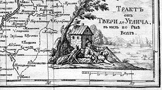
Русский: Село Талдома на карте из Атласа "Географическое описание реки Волги от Твери до Дмитриевска для путешествия Ея Императорскаго Величества по оной реке", составленным И. И. Стафенгагеном И. И. в 1767 году. |
| Date | |
| Source | Стафенгаген И. И. "Географическое описание реки Волги от Твери до Дмитриевска для путешествия Ея Императорскаго Величества по оной реке." |
| Author | Стафенгаген И. И. |
Licensing
[edit]
|
This work is in the public domain in its country of origin and other countries and areas where the copyright term is the author's life plus 100 years or fewer. | |
| This file has been identified as being free of known restrictions under copyright law, including all related and neighboring rights. | |
Original upload log
[edit]
Transferred from ru.wikipedia to Commons using For the Common Good.
The original description page was here. All following user names refer to ru.wikipedia.
| Date/Time | Dimensions | User | Comment |
|---|---|---|---|
| 06:10, 17 March 2014 | 3,458 × 1,908 (3,353,032 bytes) | w:ru:Gerodian (talk | contribs) | {{Изображение | Описание = Село Талдома на карте из Атласа "Географическое описание реки Волги от Твери до Дмитриевска для путешествия… |
File history
Click on a date/time to view the file as it appeared at that time.
| Date/Time | Thumbnail | Dimensions | User | Comment | |
|---|---|---|---|---|---|
| current | 10:00, 17 October 2015 | | 3,458 × 1,908 (3.2 MB) | Well-Informed Optimist (talk | contribs) | Transferred from ru.wikipedia: see original upload log above |
You cannot overwrite this file.
File usage on Commons
There are no pages that use this file.
File usage on other wikis
The following other wikis use this file: