File:Talbot Community Centre, Kenfig Hill - geograph.org.uk - 3266586.jpg
Jump to navigation
Jump to search
No higher resolution available.
Talbot_Community_Centre,_Kenfig_Hill_-_geograph.org.uk_-_3266586.jpg (640 × 480 pixels, file size: 57 KB, MIME type: image/jpeg)
Captions
Captions
Add a one-line explanation of what this file represents
Summary
[edit]
| Description |
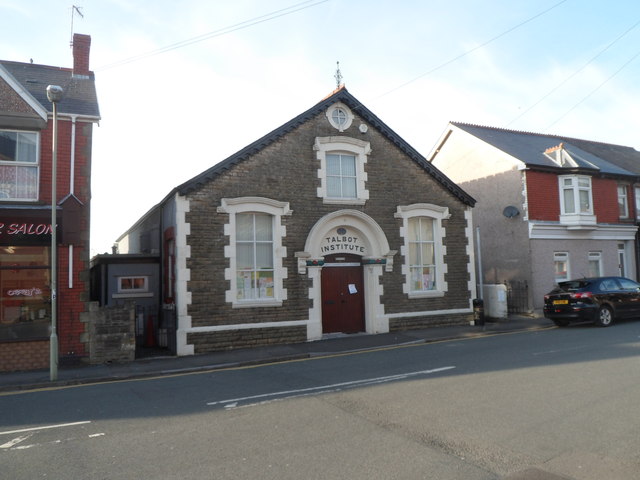
English: Talbot Community Centre, Kenfig Hill. Located in Prince Road near the B4281, the community centre is exactly that - owned and run by the local community, for the local community. Most of the people involved are volunteers. The name above the door, Talbot Institute, is a reminder of the building's earlier history. Given to Kenfig Hill by the Talbot family in 1911, the building was in use as Talbot Miners' Welfare Institute until closure of the last local colliery in 1959. |
| Date | |
| Source | From geograph.org.uk |
| Author | Jaggery |
| Permission (Reusing this file) |
Creative Commons Attribution Share-alike license 2.0 |
| Attribution (required by the license) | Jaggery / Talbot Community Centre, Kenfig Hill / |
| Camera location | | View this and other nearby images on: OpenStreetMap |
|---|
Licensing
[edit]

|
This image was taken from the Geograph project collection. See this photograph's page on the Geograph website for the photographer's contact details. The copyright on this image is owned by Jaggery and is licensed for reuse under the Creative Commons Attribution-ShareAlike 2.0 license.
|
This file is licensed under the Creative Commons Attribution-Share Alike 2.0 Generic license.
Attribution: Jaggery
- You are free:
- to share – to copy, distribute and transmit the work
- to remix – to adapt the work
- Under the following conditions:
- attribution – You must give appropriate credit, provide a link to the license, and indicate if changes were made. You may do so in any reasonable manner, but not in any way that suggests the licensor endorses you or your use.
- share alike – If you remix, transform, or build upon the material, you must distribute your contributions under the same or compatible license as the original.
File history
Click on a date/time to view the file as it appeared at that time.
| Date/Time | Thumbnail | Dimensions | User | Comment | |
|---|---|---|---|---|---|
| current | 18:07, 27 August 2016 | | 640 × 480 (57 KB) | Salen9 (talk | contribs) | == {{int:filedesc}} == {{Information |Description={{en|1=Talbot Community Centre, Kenfig Hill. Located in Prince Road near the B4281, the community centre is exactly that - owned and run by the local community, for the local community. Most of the peop... |
You cannot overwrite this file.
File usage on Commons
There are no pages that use this file.
File usage on other wikis
The following other wikis use this file:
- Usage on www.wikidata.org