File:Taipien by woinary in Kumamoto.jpg
Jump to navigation
Jump to search

Size of this preview: 800 × 533 pixels. Other resolutions: 320 × 213 pixels | 640 × 427 pixels | 1,024 × 682 pixels | 1,280 × 853 pixels.
Original file (1,280 × 853 pixels, file size: 347 KB, MIME type: image/jpeg)
Captions
Captions
Add a one-line explanation of what this file represents
| Camera location | | View this and other nearby images on: OpenStreetMap |
|---|
Summary
[edit]
| Description |
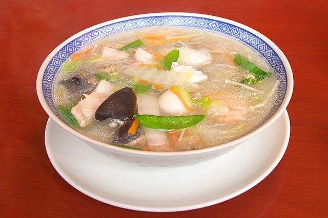
日本語: 熊本名物の春雨スープ「太平燕」(熊本市健軍2-26-14、健軍校前駅最寄り、健軍神社そばの中華料理店「中国料理雲南」) MAP by ALPSLAB「熊本名物の太平燕(タイピーエン、または、タイピンエン)。おおざっぱに言えばチャンポンの麺を春雨にしたものとも言えるが、この太平燕のスープはチャンポンぽくはない。熊本ではごく普通にどこでも食べることができるそうだが、熊本以外ではあまり見かけない。ただし、最近は熊本以外でも太平燕を出す店も増えている。 ちなみに、これは健軍の雲南という店のもの。」 Tai Pin En / 太平燕 |
| Date | |
| Source | Flickr |
| Author | woinary from Chinese restaurant Unnan in Kumamoto, Kumamoto |
| Reviewer | Opponent |
Licensing
[edit]
This file is licensed under the Creative Commons Attribution-Share Alike 2.0 Generic license.
- You are free:
- to share – to copy, distribute and transmit the work
- to remix – to adapt the work
- Under the following conditions:
- attribution – You must give appropriate credit, provide a link to the license, and indicate if changes were made. You may do so in any reasonable manner, but not in any way that suggests the licensor endorses you or your use.
- share alike – If you remix, transform, or build upon the material, you must distribute your contributions under the same or compatible license as the original.
| This image was originally posted to Flickr by woinary at https://www.flickr.com/photos/37807125@N00/458754668. It was reviewed on 5 July 2007 by FlickreviewR and was confirmed to be licensed under the terms of the cc-by-sa-2.0. |
File history
Click on a date/time to view the file as it appeared at that time.
| Date/Time | Thumbnail | Dimensions | User | Comment | |
|---|---|---|---|---|---|
| current | 11:50, 30 June 2007 | | 1,280 × 853 (347 KB) | Opponent (talk | contribs) | == Summary == {{ja| 熊本名物の春雨スープ「太平燕」(熊本市健軍、水前寺駅最寄り、健軍神社付近の中華料理� |
You cannot overwrite this file.
File usage on Commons
There are no pages that use this file.
File usage on other wikis
The following other wikis use this file: