File:Tahoe draba, Draba asterophora (22427982484).jpg
Jump to navigation
Jump to search

Size of this preview: 800 × 600 pixels. Other resolutions: 320 × 240 pixels | 640 × 480 pixels | 1,024 × 768 pixels | 1,280 × 960 pixels | 2,560 × 1,920 pixels | 3,648 × 2,736 pixels.
Original file (3,648 × 2,736 pixels, file size: 5.87 MB, MIME type: image/jpeg)
Captions
Captions
Add a one-line explanation of what this file represents
Summary
[edit].jpg&action=edit§ion=1)
| Description |
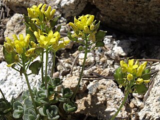
Tahoe draba, Draba asterophora, Slide Mountain, Sierra Nevada, Carson Range, Humboldt Toiyabe National Forest, elevation 2690 m (8830 ft). Substrate is rocky granitic colluvium. Also visible are needles of lodgepole pine (Pinus contorta subsp. murrayana). This rare plant is known only from the Mount Rose and Slide Mountain areas of the northern Carson Range in extreme western Nevada, in and just outside of the Lake Tahoe drainage basin. The diploid progenitor of this autotetraploid species survives in a separate population at the south end of the Carson Range in the Heavenly Mountain and Freel Peak areas on either side of the California-Nevada border. An auto-octoploid named var. macrocarpa comprises a third isolated population in the Cup Lake area of California. |
| Date | |
| Source | Tahoe draba, Draba asterophora |
| Author | Jim Morefield from Nevada, USA |
Licensing
[edit].jpg&action=edit§ion=2)
This file is licensed under the Creative Commons Attribution-Share Alike 2.0 Generic license.
- You are free:
- to share – to copy, distribute and transmit the work
- to remix – to adapt the work
- Under the following conditions:
- attribution – You must give appropriate credit, provide a link to the license, and indicate if changes were made. You may do so in any reasonable manner, but not in any way that suggests the licensor endorses you or your use.
- share alike – If you remix, transform, or build upon the material, you must distribute your contributions under the same or compatible license as the original.
| This image was originally posted to Flickr by Jim Morefield at https://flickr.com/photos/127605180@N04/22427982484 (archive). It was reviewed on 29 December 2019 by FlickreviewR 2 and was confirmed to be licensed under the terms of the cc-by-sa-2.0. |
File history
Click on a date/time to view the file as it appeared at that time.
| Date/Time | Thumbnail | Dimensions | User | Comment | |
|---|---|---|---|---|---|
| current | 03:48, 29 December 2019 | | 3,648 × 2,736 (5.87 MB) | Ser Amantio di Nicolao (talk | contribs) | Transferred from Flickr via #flickr2commons |
You cannot overwrite this file.
File usage on Commons
There are no pages that use this file.
File usage on other wikis
The following other wikis use this file:
- Usage on ceb.wikipedia.org
- Usage on en.wikipedia.org
.jpg&oldid=925646290)