File:Tagesliniennetz Stadtverkehr Hildesheim.png
Jump to navigation
Jump to search
Size of this preview: 800 × 566 pixels. Other resolutions: 320 × 226 pixels | 640 × 452 pixels | 1,024 × 724 pixels | 1,280 × 905 pixels | 2,000 × 1,414 pixels.
Original file (2,000 × 1,414 pixels, file size: 751 KB, MIME type: image/png)
Captions
Captions
Add a one-line explanation of what this file represents
Summary
[edit]
| Description |
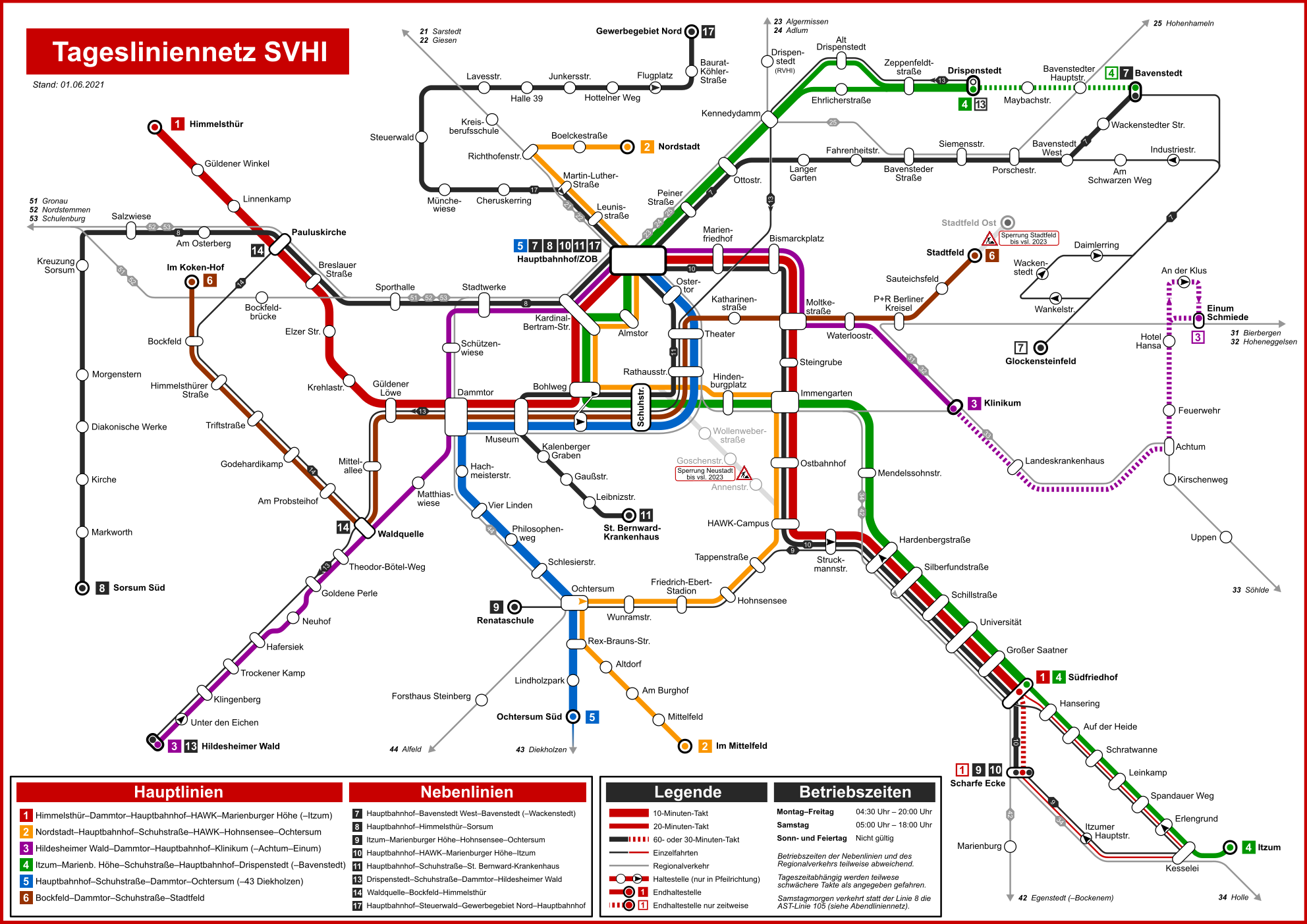
Deutsch: Tagesliniennetz Stadtverkehr Hildesheim |
| Date | |
| Source | Own work |
| Author | Walkman Revolution |
Licensing
[edit]
I, the copyright holder of this work, hereby publish it under the following license:
This file is licensed under the Creative Commons Attribution 3.0 Unported license.
- You are free:
- to share – to copy, distribute and transmit the work
- to remix – to adapt the work
- Under the following conditions:
- attribution – You must give appropriate credit, provide a link to the license, and indicate if changes were made. You may do so in any reasonable manner, but not in any way that suggests the licensor endorses you or your use.
File history
Click on a date/time to view the file as it appeared at that time.
| Date/Time | Thumbnail | Dimensions | User | Comment | |
|---|---|---|---|---|---|
| current | 15:38, 10 July 2024 | | 2,000 × 1,414 (751 KB) | Walkman Revolution (talk | contribs) | Neue Version, Stand Juli 2024 |
| 17:11, 4 July 2021 |  | 1,984 × 1,403 (726 KB) | Walkman Revolution (talk | contribs) | Änderungen im Liniennetz | |
| 15:36, 12 April 2020 |  | 1,985 × 1,404 (719 KB) | Walkman Revolution (talk | contribs) | Aufhebung Baustelle Roonstraße. | |
| 19:34, 5 July 2019 |  | 1,985 × 1,404 (731 KB) | Walkman Revolution (talk | contribs) | Änderungen ab 04.07.2019. | |
| 15:58, 18 November 2018 |  | 1,985 × 1,404 (720 KB) | Walkman Revolution (talk | contribs) | Baustelle Roonstraße seit 10/2018. | |
| 22:41, 16 May 2018 |  | 1,984 × 1,403 (717 KB) | Walkman Revolution (talk | contribs) | Kleine Korrekturen. | |
| 18:44, 12 August 2017 |  | 1,985 × 1,404 (708 KB) | Walkman Revolution (talk | contribs) | Korrigiert. | |
| 23:24, 2 August 2017 |  | 1,985 × 1,404 (709 KB) | Walkman Revolution (talk | contribs) | Gültig ab 03.08.2017. | |
| 23:36, 31 July 2017 |  | 1,323 × 1,871 (553 KB) | Walkman Revolution (talk | contribs) | Korrigiert. | |
| 19:27, 27 July 2017 |  | 1,323 × 1,871 (555 KB) | Walkman Revolution (talk | contribs) | Neue Version. |
You cannot overwrite this file.
File usage on Commons
The following 31 pages use this file:
- User:Chumwa/OgreBot/Potential transport maps/2017 August 1-10
- User:Chumwa/OgreBot/Potential transport maps/2017 August 11-20
- User:Chumwa/OgreBot/Potential transport maps/2017 July 21-31
- User:Chumwa/OgreBot/Potential transport maps/2018 May 11-20
- User:Chumwa/OgreBot/Potential transport maps/2018 November 11-20
- User:Chumwa/OgreBot/Potential transport maps/2019 July 1-10
- User:Chumwa/OgreBot/Public transport information/2017 August 1-10
- User:Chumwa/OgreBot/Public transport information/2017 August 11-20
- User:Chumwa/OgreBot/Public transport information/2017 July 21-31
- User:Chumwa/OgreBot/Public transport information/2018 May 11-20
- User:Chumwa/OgreBot/Public transport information/2018 November 11-20
- User:Chumwa/OgreBot/Public transport information/2019 July 1-10
- User:Chumwa/OgreBot/Public transport information/2020 April 11-20
- User:Chumwa/OgreBot/Public transport information/2021 July 1-10
- User:Chumwa/OgreBot/Public transport information/2024 July 1-10
- User:Chumwa/OgreBot/Transport Maps/2017 August 1-10
- User:Chumwa/OgreBot/Transport Maps/2017 August 11-20
- User:Chumwa/OgreBot/Transport Maps/2017 July 21-31
- User:Chumwa/OgreBot/Transport Maps/2018 May 11-20
- User:Chumwa/OgreBot/Transport Maps/2018 November 11-20
- User:Chumwa/OgreBot/Transport Maps/2019 July 1-10
- User:Chumwa/OgreBot/Transport Maps/2020 April 11-20
- User:Chumwa/OgreBot/Transport Maps/2021 July 1-10
- User:Chumwa/OgreBot/Transport Maps/2024 July 1-10
- User:Chumwa/OgreBot/Travel and communication maps/2017 August 1-10
- User:Chumwa/OgreBot/Travel and communication maps/2017 August 11-20
- User:Chumwa/OgreBot/Travel and communication maps/2017 July 21-31
- User:Chumwa/OgreBot/Travel and communication maps/2018 May 11-20
- User:Chumwa/OgreBot/Travel and communication maps/2018 November 11-20
- User:Chumwa/OgreBot/Travel and communication maps/2019 July 1-10
- User:Chumwa/OgreBot/Travel and communication maps/2024 July 1-10
File usage on other wikis
The following other wikis use this file:
- Usage on de.wikipedia.org
- Usage on nl.wikipedia.org