File:Tachtigjarige oorlog-1579.svg
Jump to navigation
Jump to search

Size of this PNG preview of this SVG file: 458 × 600 pixels. Other resolutions: 183 × 240 pixels | 366 × 480 pixels | 586 × 768 pixels | 782 × 1,024 pixels | 1,564 × 2,048 pixels | 1,651 × 2,162 pixels.
Original file (SVG file, nominally 1,651 × 2,162 pixels, file size: 899 KB)
Captions
Captions
Add a one-line explanation of what this file represents
Summary
[edit]
| Description |
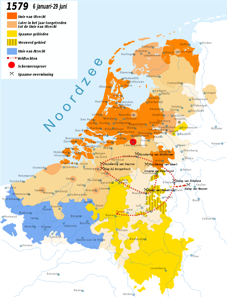
Krijgsbewegingen in de Tachtigjarige Oorlog. 1579. Español: Situación de los Países Bajos en 1579, durante la guerra de Flandes. En rojo el territorio bajo dominio de las Provincias Unidas; en marrón claro, territorios conquistados por éstas bajo el mando de Mauricio de Nassau y Guillermo Luis de Nassau; en amarillo los territorios bajo control español. |
| Date | |
| Source | Own work based on File:Tachtigjarigeoorlog-1579.png |
| Author | Henk Boelens |
| Other versions | File:Tachtigjarigeoorlog-1579.png |
Licensing
[edit]
I, the copyright holder of this work, hereby publish it under the following licenses:

|
Permission is granted to copy, distribute and/or modify this document under the terms of the GNU Free Documentation License, Version 1.2 or any later version published by the Free Software Foundation; with no Invariant Sections, no Front-Cover Texts, and no Back-Cover Texts. A copy of the license is included in the section entitled GNU Free Documentation License. |
This file is licensed under the Creative Commons Attribution-Share Alike 3.0 Unported, 2.5 Generic, 2.0 Generic and 1.0 Generic license.
- You are free:
- to share – to copy, distribute and transmit the work
- to remix – to adapt the work
- Under the following conditions:
- attribution – You must give appropriate credit, provide a link to the license, and indicate if changes were made. You may do so in any reasonable manner, but not in any way that suggests the licensor endorses you or your use.
- share alike – If you remix, transform, or build upon the material, you must distribute your contributions under the same or compatible license as the original.
You may select the license of your choice.
File history
Click on a date/time to view the file as it appeared at that time.
| Date/Time | Thumbnail | Dimensions | User | Comment | |
|---|---|---|---|---|---|
| current | 15:12, 16 July 2022 | | 1,651 × 2,162 (899 KB) | Nederlandse Leeuw (talk | contribs) | Corrected the location of some towns in the south such as Doornik/Tournai, Namen/Namur, Dowaai/Douai, Dinant, Luxemburg, Hoei/Huy etc.. This seems to be a problem in all .svg maps of Henk B. |
| 16:31, 30 May 2022 |  | 1,651 × 2,162 (900 KB) | Nederlandse Leeuw (talk | contribs) | Cambrésis coloured light beige. It was in the HRE but not in the Habsburg Netherlands, nor the Union of Arras. | |
| 16:26, 10 August 2013 |  | 1,651 × 2,162 (900 KB) | Henk B. (talk | contribs) | Reverted to version as of 08:13, 6 August 2013 | |
| 16:11, 10 August 2013 |  | 1,651 × 2,162 (914 KB) | Henk B. (talk | contribs) | -roermond | |
| 16:03, 10 August 2013 |  | 1,651 × 2,162 (914 KB) | Henk B. (talk | contribs) | another update | |
| 08:13, 6 August 2013 |  | 1,651 × 2,162 (900 KB) | Henk B. (talk | contribs) | legenda | |
| 06:17, 6 August 2013 |  | 1,651 × 2,162 (900 KB) | Henk B. (talk | contribs) | update | |
| 19:20, 16 July 2013 |  | 1,651 × 2,162 (630 KB) | Henk B. (talk | contribs) | == {{int:filedesc}} == {{Information |Description=Krijgsbewegingen in de Tachtigjarige Oorlog. 1579. {{es|Situación de los Países Bajos en 1579, durante la guerra de Flandes. En rojo el territorio bajo dominio de las Provincias Unidas; en marrón cl... |
You cannot overwrite this file.
File usage on Commons
The following 4 pages use this file:
File usage on other wikis
The following other wikis use this file:
- Usage on en.wikipedia.org
- Usage on nl.wikipedia.org