File:Haitang 2005-07-17 0825Z.jpg
(Redirected from File:TY Haitang.jpg)

Size of this preview: 800 × 593 pixels. Other resolutions: 320 × 237 pixels | 640 × 474 pixels | 1,024 × 758 pixels | 1,280 × 948 pixels.
Original file (1,280 × 948 pixels, file size: 308 KB, MIME type: image/jpeg)
Captions
Captions
Add a one-line explanation of what this file represents
Summary
[edit]
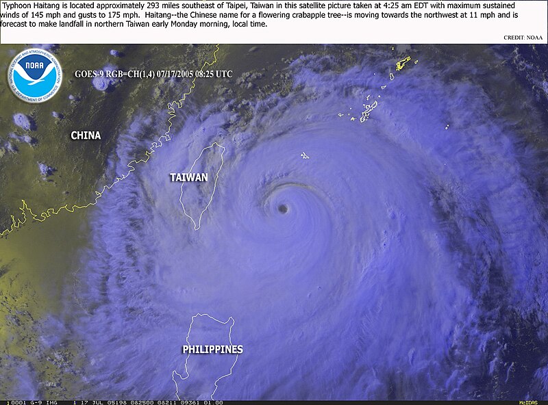
| Description | Typhoon Haitang is located approximately 293 miles southeast of Taipei, Taiwan in this satellite picture taken at 4:25 EDT with maximum sustained winds of 145 mph and gusts to 175 mph. Haitang--the Chinese name for a flowering crabapple tree--is moving towards the northwest at 11 mph is forecast to make landfall in northern Taiwan early Monday morning, local time. | |||
| Date | ||||
| Source | http://www.osei.noaa.gov/Events/Tropical/W_Pacific/2005/TRCHaitang198_G9.jpg | |||
| Author | NOAA / Operational Significant Event Imagery | |||
| Permission (Reusing this file) |
|
File history
Click on a date/time to view the file as it appeared at that time.
| Date/Time | Thumbnail | Dimensions | User | Comment | |
|---|---|---|---|---|---|
| current | 11:27, 18 July 2005 | | 1,280 × 948 (308 KB) | KaurJmeb (talk | contribs) | 07/17/2005 8:25 UTC海棠颱風位置。<BR>圖片來源:http://www.osei.noaa.gov/ {{PD}} |
You cannot overwrite this file.
File usage on Commons
The following page uses this file:
- File:TY Haitang.jpg (file redirect)
File usage on other wikis
The following other wikis use this file:
- Usage on zh-min-nan.wikipedia.org