File:TV-009-0425 (15024900619).jpg

Original file (1,573 × 1,164 pixels, file size: 439 KB, MIME type: image/jpeg)
Captions
Captions
Summary
[edit].jpg&action=edit§ion=1)
| Description |
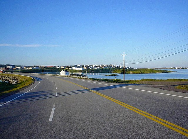
Channel-Port aux Basques, Newfoundland. The "skyline" of Port aux Basques as seen from the Trans-Canada Highway. Port aux Basques sports a population of about 4,000 and an economic and historic importance that is derived largely from its status as by far Newfoundland's largest port of entry for overland travellers and cargo: being twice as close as any other Newfoundland port to the Canadian mainland, which lies 125 miles (200 km) away across the always ice-free Cabot Strait, the ferry service to Cape Breton that was launched in 1898 now brings over half a million passengers a year to Newfoundland and handles significant freight traffic as well. The harbour was known to seamen as early as the 17th century: it took its name from the Basque whalers who used to take refuge there on their way to and from Labrador, stocking up on provisions including fresh water from Dead Man's Brook. However, permanent settlement at Port aux Basques didn't occur until the early 18th Century, when Acadian fishermen from Cape Breton arrived in the wake of the signing of the Treaty of Utrecht, which established French fishing rights in the waters off the west and north shores of Newfoundland (the so-called "French Shore" or "Treaty Shore"). Over time, Port aux Basques grew from a cluster of sleepy fishing villages to a population centre and economic nucleus for southwestern Newfoundland, taking on its current official name in 1945 when it merged with the adjacent town of Channel (locals nearly always call it simply "Port aux Basques", though). Amalgamation continued through the 1970s, when the villages of Grand Bay and Mouse Island became part of Port aux Basques. Channel-Port-aux-Basques, Terre-Neuve. La silhouette du centre-ville de Port-aux-Basques comme on la voit à partir de la route Transcanadienne. Port-aux-Basques compte une population d'environ 4.000 et une importance économique et historique qui est dérivé en grande mesure de son statut comme de loin le plus grand port d'entrée à Terre-Neuve pour les voyageurs et le fret qui viennent par voie terrestre: se situant deux fois plus près de la partie continentale du Canada que tout autre port terre-neuvien, 200 kilomètres à travers le détroit de Cabot toujours libre de glace, le service de ferry au Cap-Breton qui a été lancé en 1898 emmène aujourd'hui plus qu'un demi-million de passagers à Terre-Neuve chaque année et gère aussi beaucoup de trafic de marchandises. Le port a été connu aux marins dès le XVIIe siècle: il a pris son nom des baleiniers basques qui se réfugiaient là en ces jours en route vers et depuis le Labrador et qui s'aprovisionnaient en des nécessités, y compris l'eau douce du ruisseau Dead-Man. Toutefois, il n'y avait aucune colonisation permanente à Port-aux-Basques jusqu'au début du XVIIIe siècle, lorsque les pêcheurs acadiens son arrivés du Cap-Breton par la suite de la signature du traité d'Utrecht, qui a établi les droits de pêche pour les Français dans les eaux au large des côtes ouest et nord de Terre-Neuve (qui on appellait la «Côte française» ou la «Côte du Traité»). Au fil du temps, Port-aux-Basques a grandi d'un grappe de petits villages de pêcheurs à un centre de population et un noyau économique pour le sud-ouest de Terre-Neuve; il a pris son nom officiel actuel en 1945 quand il s'est fusionné avec la ville voisine de Channel (même si les habitants l'appellent presque toujours tout simplement «Port-aux-Basques»). La fusion s'est poursuit jusqu'aux années 1970, lorsque les villages de Grand Bay et Mouse Island sont devenus partie de Port-aux-Basques. Channel-Port aux Basques, Terranova. El perfil del centro de Port aux Basques según lo visto desde la Carretera Transcanadiense. Port aux Basques cuenta una población de alrededor de 4.000 y una importancia económica e histórica que se deriva en gran parte de su estado como con mucho el mayor puerto de entrada de Terranova para los viajeros y la carga que llegan por tierra: se ubicando dos veces más cerca a la parte continental de Canadá que cualquier otro puerto terranoviense, a 200 kilómetros de distancia a través del Estrecho de Caboto que está siempre libre de hielo, el servicio de transbordador al Cabo Bretón que se lanzó en 1898 hoy lleva a más que medio millón de pasajeros cada año a Terranova y también trata con mucho tráfico de mercancías. El puerto ya se conocía por los marinos en el siglo XVII: tomó su nombre de los balleneros vascos ("vasco" se traduce en inglés y francés como "Basque") que solían refugiarse allí en ruta hacia y desde Labrador y que se abastecían de provisiones incluyendo el agua fresca del Arroyo Dead Man. Sin embargo, ninguna colonización permanente tuvo lugar en Port aux Basques hasta el principio del siglo XVIII, cuando los pescadores acadienses llegaron de Cabo Bretón a raíz de la firma del Tratado de Utrecht, que estableció los derechos de pesca para los franceses en las aguas frente a las costas oeste y norte de Terranova (que se llamaba la "Costa Francesa" o la "Costa del Tratado"). Con el tiempo, Port aux Basques creció de un grupo de pueblos tranquilos de pescadores a un centro de la población y un núcleo económico para el sudoeste de Terranova, tomando su nombre oficial actual en 1945 cuando se fusionó con el pueblo cercano de Channel (aunque los habitantes casi siempre lo llamen simplemente "Port aux Basques"). La fusión continuó hasta los años 1970, cuando los pueblos de Grand Bay y Mouse Island se hicieron partes de Port aux Basques. |
| Date | |
| Source | TV-009-0425 |
| Author | André Carrotflower |
Licensing
[edit].jpg&action=edit§ion=2)
- You are free:
- to share – to copy, distribute and transmit the work
- to remix – to adapt the work
- Under the following conditions:
- attribution – You must give appropriate credit, provide a link to the license, and indicate if changes were made. You may do so in any reasonable manner, but not in any way that suggests the licensor endorses you or your use.
- share alike – If you remix, transform, or build upon the material, you must distribute your contributions under the same or compatible license as the original.
| This image was originally posted to Flickr by Carrotflower Productions International at https://flickr.com/photos/59639129@N08/15024900619. It was reviewed on 17 June 2020 by FlickreviewR 2 and was confirmed to be licensed under the terms of the cc-by-sa-2.0. |
File history
Click on a date/time to view the file as it appeared at that time.
| Date/Time | Thumbnail | Dimensions | User | Comment | |
|---|---|---|---|---|---|
| current | 16:15, 17 June 2020 | | 1,573 × 1,164 (439 KB) | Mindmatrix (talk | contribs) | Transferred from Flickr via #flickr2commons |
You cannot overwrite this file.
File usage on Commons
There are no pages that use this file.
.jpg&oldid=878674721)