File:TTC subway map 2018.svg
Jump to navigation
Jump to search

Size of this PNG preview of this SVG file: 800 × 533 pixels. Other resolutions: 320 × 213 pixels | 640 × 427 pixels | 1,024 × 683 pixels | 1,280 × 853 pixels | 2,560 × 1,707 pixels | 3,150 × 2,100 pixels.
Original file (SVG file, nominally 3,150 × 2,100 pixels, file size: 109 KB)
Captions
Captions
Add a one-line explanation of what this file represents
This file was derived from:
This vector image includes elements that have been taken or adapted from this file:
Summary
[edit]| Description |
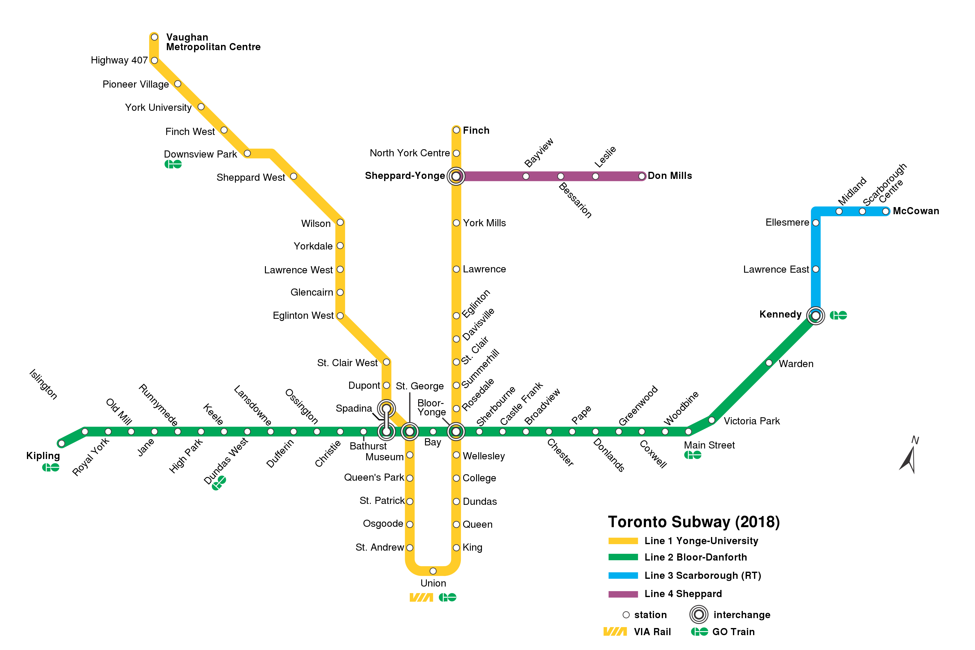
English: TTC subway/RT map (as of 2018); |
| Date | |
| Source | TTC_subway_map_2015.svg TTC_subway_map_2018.png |
| Author |
Original: Vector: |
| Other versions |
|


Licensing
[edit]
This file is licensed under the Creative Commons Attribution-Share Alike 4.0 International license.
- You are free:
- to share – to copy, distribute and transmit the work
- to remix – to adapt the work
- Under the following conditions:
- attribution – You must give appropriate credit, provide a link to the license, and indicate if changes were made. You may do so in any reasonable manner, but not in any way that suggests the licensor endorses you or your use.
- share alike – If you remix, transform, or build upon the material, you must distribute your contributions under the same or compatible license as the original.
File history
Click on a date/time to view the file as it appeared at that time.
| Date/Time | Thumbnail | Dimensions | User | Comment | |
|---|---|---|---|---|---|
| current | 03:56, 14 January 2021 | | 3,150 × 2,100 (109 KB) | Blaixx (talk | contribs) | Fix spelling of "Centre" |
| 22:13, 26 December 2020 |  | 3,150 × 2,100 (109 KB) | AquitaneHungerForce (talk | contribs) | St. Clair was labeled St. Clair West | |
| 16:04, 17 January 2020 |  | 3,150 × 2,100 (106 KB) | AquitaneHungerForce (talk | contribs) | Added missing station name and completed vectorization process. Texted remaining station names. Cleaned up Spadina interchange. | |
| 15:28, 17 January 2020 |  | 3,150 × 2,100 (153 KB) | AquitaneHungerForce (talk | contribs) | Fixed various spellings of "Sheppard" as pointed out by User:Transportfan70. | |
| 20:52, 16 December 2019 |  | 3,150 × 2,100 (153 KB) | AquitaneHungerForce (talk | contribs) | Hand-vectorizes all the stops on lines 1 and 4, along with the Bay and Sherbourne stops on line 2. Moved a stray green square to the correct location. | |
| 19:57, 16 December 2019 |  | 3,150 × 2,100 (166 KB) | AquitaneHungerForce (talk | contribs) | {{Information |description ={{en|1= TTC subway/RT map (as of 2018);}} |date =2019-12-16 |source =TTC_subway_map_2015.svg TTC_subway_map_2018.png |author =Transportfan70 Craftwerker }} Category:Public transport maps |
You cannot overwrite this file.
File usage on Commons
The following 16 pages use this file:
- User:*Youngjin/GTA transit/2020 December
- User:*Youngjin/GTA transit/2020 January
- User:*Youngjin/GTA transit/2021 January
- User:Chumwa/OgreBot/Potential transport maps/2019 December 11-20
- User:Chumwa/OgreBot/Potential transport maps/2020 January 11-20
- User:Chumwa/OgreBot/Public transport information/2019 December 11-20
- User:Chumwa/OgreBot/Public transport information/2020 December 21-31
- User:Chumwa/OgreBot/Public transport information/2020 January 11-20
- User:Chumwa/OgreBot/Public transport information/2021 January 11-20
- User:Chumwa/OgreBot/Transport Maps/2019 December 11-20
- User:Chumwa/OgreBot/Transport Maps/2020 December 21-31
- User:Chumwa/OgreBot/Transport Maps/2020 January 11-20
- User:Chumwa/OgreBot/Transport Maps/2021 January 11-20
- File:TTC subway map 2018.png
- File:TTC subway map 2018 assessment.png
- Category:Toronto subway
File usage on other wikis
The following other wikis use this file:
- Usage on bn.wikipedia.org
- Usage on ca.wikipedia.org
- Usage on es.wikipedia.org
- Usage on id.wikipedia.org
- Usage on it.wikipedia.org
- Usage on uk.wikipedia.org
- Usage on uz.wikipedia.org
- Usage on www.wikidata.org