File:TRMM INST2.GIF
Jump to navigation
Jump to search
No higher resolution available.
TRMM_INST2.GIF (427 × 379 pixels, file size: 84 KB, MIME type: image/gif)
Captions
Captions
Add a one-line explanation of what this file represents
Summary
[edit]
| Description |
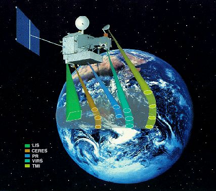
English: This drawing illustrates the CERES Earth scan pattern. As the satellite moves through its orbit, the detectors scan from one side of the ground track to the other, making measurements of energy from the Earth's atmosphere.
Português: Desenho inlustra o padrão de escaneamento da Terra pelo CERES. De acordo com o movimento do satélite em sua órbita, os detectores escaneiam de um lado a faixa de terra enquanto outro mede a energia da atmosfera terrestre |
| Date | circa 1999 |
| Source | CERES/TRMM Pictures |
| Author | NASA |
Licensing
[edit]
| This file is in the public domain in the United States because it was solely created by NASA. NASA copyright policy states that "NASA material is not protected by copyright unless noted". (See Template:PD-USGov, NASA copyright policy page or JPL Image Use Policy.) | ||
 |
Warnings:
|
File history
Click on a date/time to view the file as it appeared at that time.
| Date/Time | Thumbnail | Dimensions | User | Comment | |
|---|---|---|---|---|---|
| current | 17:56, 18 April 2008 | | 427 × 379 (84 KB) | Delemon (talk | contribs) | {{Information |Description={{en|This drawing illustrates the CERES Earth scan pattern. As the satellite moves through its orbit, the detectors scan from one side of the ground track to the other, making measurements of energy from the Earth's atmosphere.} |
You cannot overwrite this file.
File usage on Commons
There are no pages that use this file.