File:TOURNAI (Doornik) —Façade et toiture de la maison sise 35 rue des Sœurs Noires.jpg

Original file (3,400 × 5,100 pixels, file size: 4.43 MB, MIME type: image/jpeg)
Captions
Captions
Summary
[edit]_%E2%80%94Fa%C3%A7ade_et_toiture_de_la_maison_sise_35_rue_des_S%C5%93urs_Noires.jpg&action=edit§ion=1)
| Description |
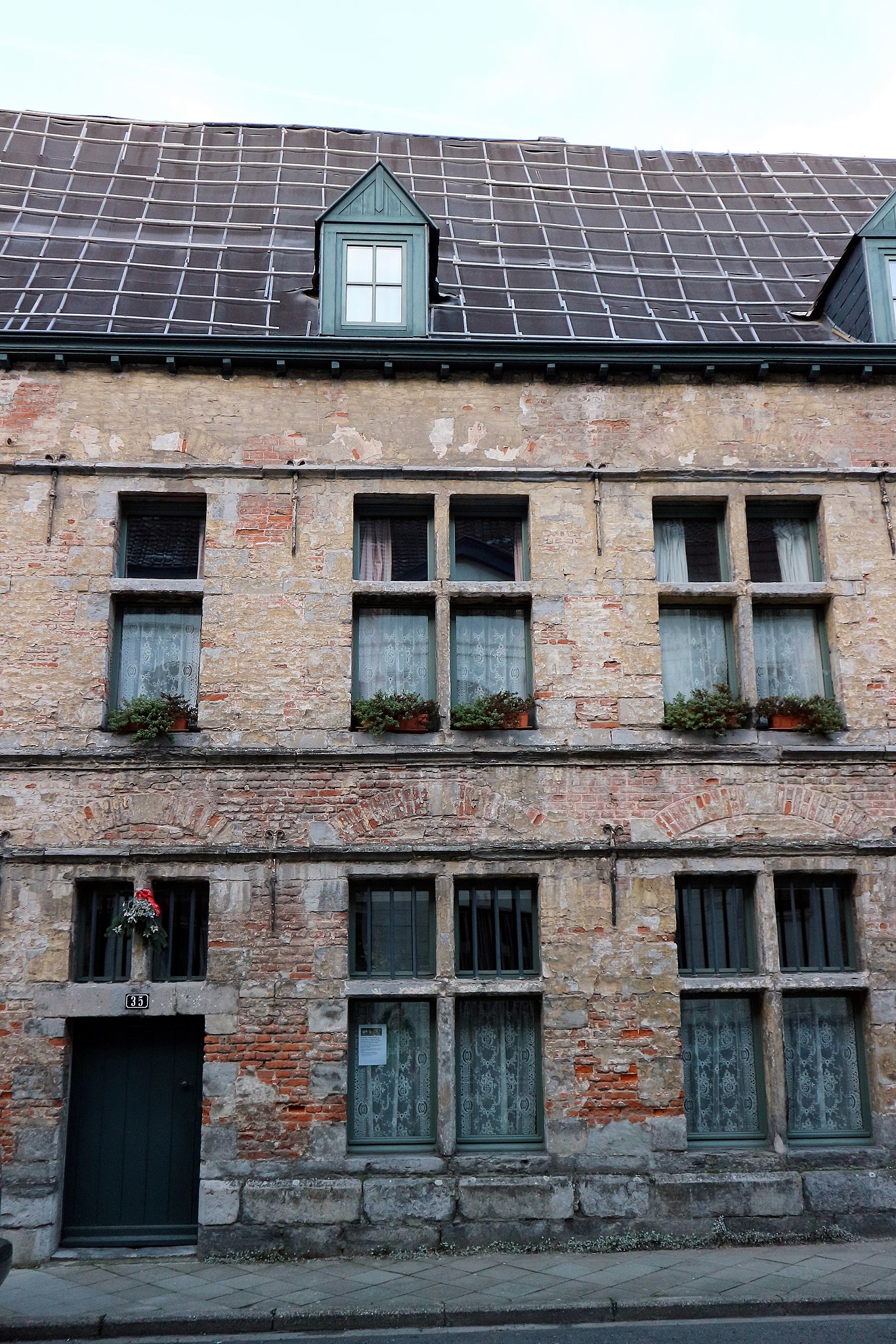
Français : TOURNAI (Doornik) —Façade et toiture de la maison sise 35 rue des Sœurs Noires.
Un des ensembles architecturaux remarquables de la Ville de Tournai, trois maisons traditionnelles construites à la fin du XVIIe siècle s’élèvent chacune sur deux niveaux de deux travées sur soubassement appareillé. L’homogénéité de la façade est conférée par les bandeaux continus reliant linteaux et seuils des baies ainsi que par un ancien enduit jaune. Les fenêtres ont gardé leur meneau (baie d’imposte), traverse, et croisées (baies du premier étage) sous un arc de décharge en briques. Une toiture en bâtière aiguë et continue, ouverte de trois lucarnes en bâtière, surmonte l’ensemble. La partie droite de la façade - visible ici sur cette photo-, constituant une septième travée, est occupée par un imposant portail en arc surbaissé sous archivolte, résultant probablement de remaniements. voir / See / Zie : https://www.cirkwi.com/fr/point-interet/184449-immeuble-rue-des-soeurs-noires-31-37 & http://qrwallonie.be/TOURN159Nederlands: Doornik —Gevel en dak van het gebouw rue des Sœurs Nr. 35
Een van de opmerkelijke architecturale complexen van de stad Doornik, drie traditionele huizen gebouwd op het einde van de 17e eeuw, staan elk op twee niveaus van twee baaien op een dubbele kelder. De homogeniteit van de gevel wordt verleend door de doorlopende banden die de lateien en drempels van de openingen met elkaar verbinden en door een oude gele pleister. De ramen hebben hun mullion (travee), crossover en crossover (traveeën op de eerste verdieping) --- onder een ontladingsboog van bakstenen. Een acuut en doorlopend zadeldak, geopend door drie dakkapellen, overstijgt het geheel. Het rechterdeel van de gevel - hier zichtbaar - dat een zevende baai vormt, wordt ingenomen door een imposant laag boogportaal onder de archivolt, waarschijnlijk als gevolg van herschikking.English: Tournai —Facade and roof of the building rue des Sœurs Noires, N. 35.
One of the remarkable architectural ensembles of the City of Tournai, three traditional houses built at the end of the seventeenth century each rise on two levels of two bays on substructure paired. The homogeneity of the facade is conferred by the continuous bands connecting lintels and thresholds of the berries as well as by an old yellow coating. The windows kept their mullion (transom bay), cross, and crossed (first floor bays) under a brick discharge arch. A roof gable acute and continuous, open three skylights saddle, overcomes the whole. The right side of the facade - Not visible in this photo -, constituting a seventh bay, is occupied by an imposing low-arch arched portal, probably resulting from rearrangem
|
||
| Date | |||
| Source | Own work | ||
| Author | Jpcuvelier | ||
| Other versions | https://upload.wikimedia.org/wikipedia/commons/6/67/TOURNAI_%28Doornik%29_%E2%80%94Immeubles_sis_rue_des_S%C5%93urs_Noires%2C_num%C3%A9ros_33-35-37_%26_31.jpg |
| Camera location | | View this and other nearby images on: OpenStreetMap |
|---|
_%E2%80%94Fa%C3%A7ade_et_toiture_de_la_maison_sise_35_rue_des_S%C5%93urs_Noires.jpg¶ms=050.609496_N_0003.382552_E_globe:Earth_type:camera__&language=en)
Licensing
[edit]_%E2%80%94Fa%C3%A7ade_et_toiture_de_la_maison_sise_35_rue_des_S%C5%93urs_Noires.jpg&action=edit§ion=2)
- You are free:
- to share – to copy, distribute and transmit the work
- to remix – to adapt the work
- Under the following conditions:
- attribution – You must give appropriate credit, provide a link to the license, and indicate if changes were made. You may do so in any reasonable manner, but not in any way that suggests the licensor endorses you or your use.
- share alike – If you remix, transform, or build upon the material, you must distribute your contributions under the same or compatible license as the original.
File history
Click on a date/time to view the file as it appeared at that time.
| Date/Time | Thumbnail | Dimensions | User | Comment | |
|---|---|---|---|---|---|
| current | 14:31, 27 December 2018 | | 3,400 × 5,100 (4.43 MB) | Jpcuvelier (talk | contribs) | User created page with UploadWizard |
You cannot overwrite this file.
File usage on Commons
There are no pages that use this file.
File usage on other wikis
The following other wikis use this file:
- Usage on en.wikipedia.org
- Usage on fr.wikipedia.org
- Usage on nl.wikipedia.org
_—Façade_et_toiture_de_la_maison_sise_35_rue_des_Sœurs_Noires.jpg&oldid=617817156)