File:TMD trail map.png
Jump to navigation
Jump to search

Size of this preview: 640 × 600 pixels. Other resolutions: 256 × 240 pixels | 999 × 936 pixels.
Original file (999 × 936 pixels, file size: 234 KB, MIME type: image/png)
Captions
Captions
Add a one-line explanation of what this file represents
| Description |
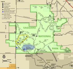
English: Map of the Tucson Mountain District of Saguaro National Park in the U.S. state of Arizona |
|||
| Date | (date of upload); unknown date of creation of the original | |||
| Source | official park map | |||
| Author | National Park Service; converted from PDF to PNG format by User:Finetooth using GNU Image Manipulation Program (GIMP) software | |||
| Permission (Reusing this file) |
|
File history
Click on a date/time to view the file as it appeared at that time.
| Date/Time | Thumbnail | Dimensions | User | Comment | |
|---|---|---|---|---|---|
| current | 02:22, 15 June 2017 | | 999 × 936 (234 KB) | Finetooth (talk | contribs) | Removed clutter in the form of numbers unexplained in the map legend. |
| 23:24, 14 June 2017 |  | 999 × 936 (314 KB) | Finetooth (talk | contribs) | {{Information |Description ={{en|1=Map of the Tucson Mountain District of Saguaro National Park in the U.S. state of Arizona}} |Source =[https://www.nps.gov/sagu/planyourvisit/upload/sentinel_fall10_tmd.pdf official park map] |Author... |
You cannot overwrite this file.
File usage on Commons
There are no pages that use this file.
File usage on other wikis
The following other wikis use this file:
- Usage on ca.wikipedia.org
- Usage on en.wikipedia.org
- Usage on eu.wikipedia.org
- Usage on he.wikipedia.org