File:THE UGANDA EQUATOR.jpg
Original file (3,453 × 2,760 pixels, file size: 1.49 MB, MIME type: image/jpeg)
Captions
Summary
[edit]DescriptionTHE UGANDA EQUATOR.jpg |
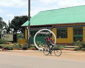
English: The Equator is located in Kayabwe, Mpigi District, about 72 kilometers from Kampala city, the capital of Uganda. You will find the poster for the Uganda Equator on Kampala-Masaka road 420 kilometers from Kampala. South west of Kampala; you will be able to locate markers of the equator in Kasese District within the Queen Elizabeth National Park. You will experience warm temperatures while at the Equator as you stand in the middle of the world. Please remember to have a sunscreen for your skin.
|
||
Date | |||
Source | Own work | ||
Author | Marvinjohnz |
Camera location | 0° 00′ 00.25″ S, 32° 02′ 23.34″ E | View this and other nearby images on: OpenStreetMap | -0.000070; 32.039818 |
---|
Licensing
[edit]- You are free:
- to share – to copy, distribute and transmit the work
- to remix – to adapt the work
- Under the following conditions:
- attribution – You must give appropriate credit, provide a link to the license, and indicate if changes were made. You may do so in any reasonable manner, but not in any way that suggests the licensor endorses you or your use.
- share alike – If you remix, transform, or build upon the material, you must distribute your contributions under the same or compatible license as the original.
This image was uploaded as part of Wiki Loves Monuments 2020.
Afrikaans ∙ Alemannisch ∙ azərbaycanca ∙ Bahasa Indonesia ∙ Bahasa Melayu ∙ Bikol Central ∙ bosanski ∙ brezhoneg ∙ català ∙ čeština ∙ Cymraeg ∙ dansk ∙ davvisámegiella ∙ Deutsch ∙ eesti ∙ English ∙ español ∙ Esperanto ∙ euskara ∙ français ∙ Frysk ∙ Gaeilge ∙ galego ∙ hrvatski ∙ Ido ∙ italiano ∙ latviešu ∙ Lëtzebuergesch ∙ Malagasy ∙ magyar ∙ Malti ∙ Nederlands ∙ norsk ∙ norsk nynorsk ∙ norsk bokmål ∙ polski ∙ português ∙ português do Brasil ∙ română ∙ shqip ∙ sicilianu ∙ slovenčina ∙ slovenščina ∙ suomi ∙ svenska ∙ Tagalog ∙ Türkçe ∙ Yorùbá ∙ Zazaki ∙ Ελληνικά ∙ беларуская ∙ беларуская (тарашкевіца) ∙ български ∙ кыргызча ∙ македонски ∙ русский ∙ српски / srpski ∙ українська ∙ ქართული ∙ հայերեն ∙ नेपाली ∙ हिन्दी ∙ বাংলা ∙ മലയാളം ∙ ไทย ∙ 한국어 ∙ +/− |
File history
Click on a date/time to view the file as it appeared at that time.
Date/Time | Thumbnail | Dimensions | User | Comment | |
---|---|---|---|---|---|
current | 09:18, 30 September 2020 | 3,453 × 2,760 (1.49 MB) | Marvinjohnz (talk | contribs) | Uploaded own work with UploadWizard |
You cannot overwrite this file.
File usage on Commons
There are no pages that use this file.
Metadata
This file contains additional information such as Exif metadata which may have been added by the digital camera, scanner, or software program used to create or digitize it. If the file has been modified from its original state, some details such as the timestamp may not fully reflect those of the original file. The timestamp is only as accurate as the clock in the camera, and it may be completely wrong.
Camera manufacturer | HUAWEI |
---|---|
Camera model | COL-L29 |
ISO speed rating | 50 |
F-number | f/1.8 |
Exposure time | 111/200,000 sec (0.000555) |
Lens focal length | 3.95 mm |
Date and time of data generation | 11:59, 30 September 2020 |
Latitude | 0° 0′ 0.25″ S |
Longitude | 32° 2′ 23.34″ E |
Altitude | 1,160.59 meters above sea level |
Width | 3,453 px |
Height | 2,760 px |
Bits per component |
|
Software used | |
File change date and time | 12:17, 30 September 2020 |
Orientation | Normal |
Y and C positioning | Centered |
Horizontal resolution | 72 dpi |
Vertical resolution | 72 dpi |
Exposure Program | Normal program |
Sensing method | One-chip color area sensor |
DateTimeDigitized subseconds | 367086 |
DateTimeOriginal subseconds | 367086 |
DateTime subseconds | 367086 |
Subject distance range | Unknown |
Sharpness | Normal |
Flash | Flash did not fire |
Saturation | Normal |
Light source | Daylight |
Contrast | Normal |
Metering mode | Pattern |
Scene control | None |
Scene capture type | Standard |
Focal length in 35 mm film | 54 mm |
Maximum land aperture | 1.69 APEX (f/1.8) |
Digital zoom ratio | 1 |
APEX exposure bias | 0 |
Date and time of digitizing | 11:59, 30 September 2020 |
White balance | Auto white balance |
APEX brightness | 0 |
Exposure mode | Auto exposure |
Image compression mode | 0.95 |
APEX aperture | 1.69 |
Meaning of each component |
|
Color space | sRGB |
Scene type | A directly photographed image |
Custom image processing | Custom process |
APEX shutter speed | 29.8973 |
Exif version | 2.1 |
Supported Flashpix version | 1 |
File source | Digital still camera |
GPS time (atomic clock) | 08:59 |
GPS date | 30 September 2020 |
GPS tag version | 2.2.0.0 |
Structured data
Items portrayed in this file
depicts
some value
30 September 2020
0°0'0.252"S, 32°2'23.345"E
0.000555 second
1.8
3.95 millimetre
- National Cultural Sites in Uganda with known IDs
- Files with coordinates missing SDC location of creation
- CC-BY-SA-4.0
- Self-published work
- Images from Wiki Loves Monuments 2020
- Images from Wiki Loves Monuments 2020 in Uganda
- Images from Wiki Loves Monuments missing SDC depicts
- Images from Wiki Loves Monuments missing SDC location of creation
- Uploaded via Campaign:wlm-ug
- Pages with maps