File:TB-Mibu Station Aerial photography.jpg
Jump to navigation
Jump to search

Size of this preview: 800 × 521 pixels. Other resolutions: 320 × 208 pixels | 640 × 417 pixels | 1,024 × 666 pixels | 1,280 × 833 pixels | 2,560 × 1,666 pixels | 3,265 × 2,125 pixels.
Original file (3,265 × 2,125 pixels, file size: 11.01 MB, MIME type: image/jpeg)
Captions
Captions
Add a one-line explanation of what this file represents
Summary
[edit]| Description |
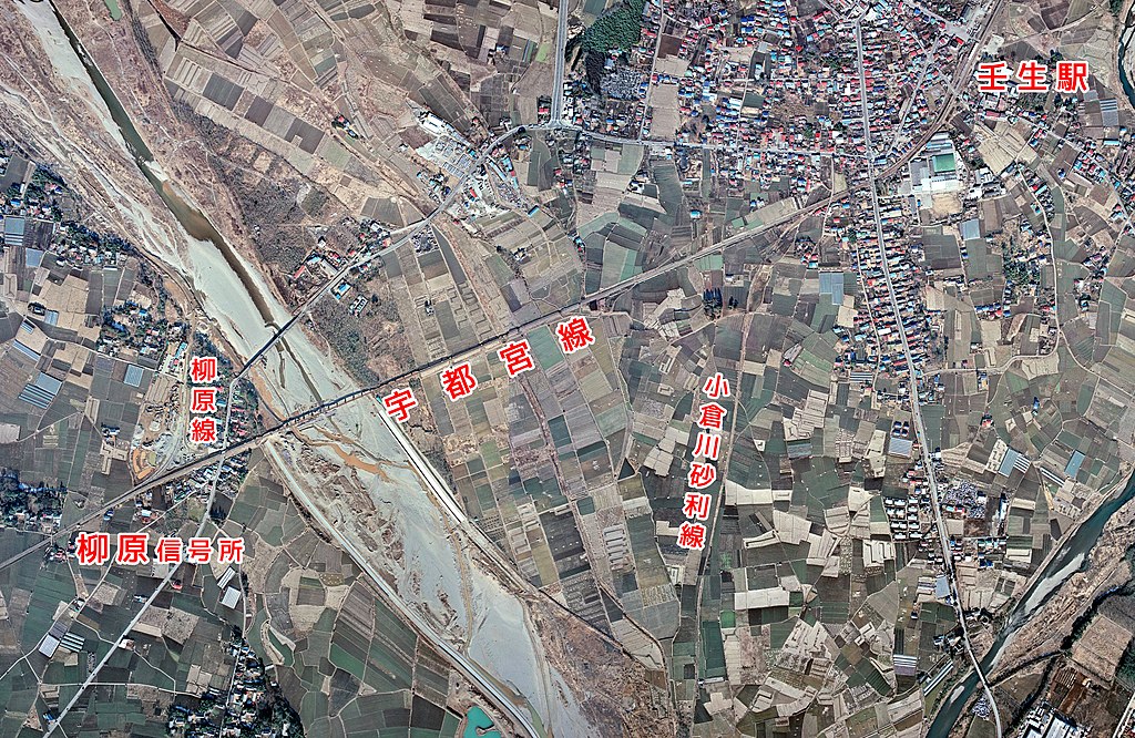
English: Tobu Utsunomiya Line. Between Yanagihara SS and Mibu Sta.. 日本語: 東武宇都宮線 柳原信号所 - 壬生間 |
| Date | |
| Source |
|
| Author |
Licensing
[edit]
|
The copyright holder of this file, Ministry of Land, Infrastructure, Transport and Tourism, allows anyone to use it for any purpose, provided that the copyright holder is properly attributed. Redistribution, derivative work, commercial use, and all other use is permitted. |
Attribution:
National Land Image Information (Color Aerial Photographs), created by Ministry of Land, Infrastructure, Transport and Tourism, distributed by Geospatial Information Authority of Japan
|

File history
Click on a date/time to view the file as it appeared at that time.
| Date/Time | Thumbnail | Dimensions | User | Comment | |
|---|---|---|---|---|---|
| current | 13:28, 18 September 2021 | | 3,265 × 2,125 (11.01 MB) | ButuCC (talk | contribs) | {{Information |description={{en|1=Tobu Utsunomiya Line. Between Yanagihara SS and Mibu Sta..}}{{ja|1=東武宇都宮線 柳原信号所 - 壬生間}} |date=1975-01-31 |source= *国土交通省「国土画像情報(カラー空中写真)」(配布元:国土地理院地図・空中写真閲覧サービス) **[https://mapps.gsi.go.jp/maplibSearch.do?specificationId=1009147 CKT7418-C16-13] **[https://mapps.gsi.go.jp/maplibSearch.do?specificationId=1009149 CKT7418-C16-15] |author={{ja|国土地理院、ButuCCが加工。}} {{en|[[:en:Geospatial Information Authority of Japan|Geospatial Informati... |
You cannot overwrite this file.
File usage on Commons
The following 2 pages use this file:
File usage on other wikis
The following other wikis use this file:
- Usage on ja.wikipedia.org