File:Szerb Vajdaság és Temesi Bánság.svg
Jump to navigation
Jump to search

Size of this PNG preview of this SVG file: 793 × 423 pixels. Other resolutions: 320 × 171 pixels | 640 × 341 pixels | 1,024 × 546 pixels | 1,280 × 683 pixels | 2,560 × 1,366 pixels.
Original file (SVG file, nominally 793 × 423 pixels, file size: 140 KB)
Captions
Captions
Add a one-line explanation of what this file represents
Summary
[edit]
| Description |
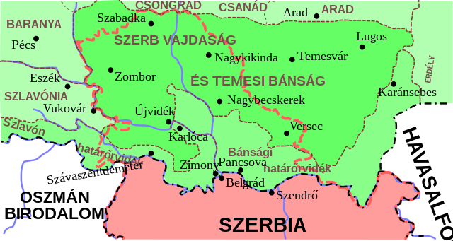
Magyar: Szerb Vajdaság és Temesi Bánság |
| Date | |
| Source | Own work |
| Author | Szajci |
Licensing
[edit]
I, the copyright holder of this work, hereby publish it under the following license:
This file is licensed under the Creative Commons Attribution-Share Alike 4.0 International license.
- You are free:
- to share – to copy, distribute and transmit the work
- to remix – to adapt the work
- Under the following conditions:
- attribution – You must give appropriate credit, provide a link to the license, and indicate if changes were made. You may do so in any reasonable manner, but not in any way that suggests the licensor endorses you or your use.
- share alike – If you remix, transform, or build upon the material, you must distribute your contributions under the same or compatible license as the original.
File history
Click on a date/time to view the file as it appeared at that time.
| Date/Time | Thumbnail | Dimensions | User | Comment | |
|---|---|---|---|---|---|
| current | 16:40, 30 June 2015 | | 793 × 423 (140 KB) | Szajci (talk | contribs) | User created page with UploadWizard |
You cannot overwrite this file.
File usage on Commons
There are no pages that use this file.
File usage on other wikis
The following other wikis use this file:
- Usage on he.wikipedia.org
- Usage on hu.wikipedia.org
Metadata
Categories:
- Voivodeship of Serbia and Banat of Temeschwar
- Maps of the Habsburg Military Frontier
- Maps of the Ottoman period in the history of Serbia
- Maps of the Habsburg period in the history of Serbia
- Maps of the history of Vojvodina
- Maps of the history of Banat
- Maps of the history of Bačka
- Maps of the history of Syrmia