File:System of gdr border fortification.gif
Jump to navigation
Jump to search

Size of this preview: 800 × 588 pixels. Other resolutions: 320 × 235 pixels | 640 × 470 pixels | 1,024 × 752 pixels | 1,280 × 940 pixels | 2,560 × 1,881 pixels | 2,853 × 2,096 pixels.
Original file (2,853 × 2,096 pixels, file size: 212 KB, MIME type: image/gif)
Captions
Captions
Add a one-line explanation of what this file represents
Summary
[edit]
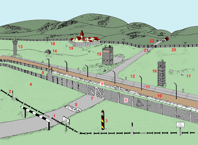
| Description |
English: Diagram of the w:inner German border fortification system circa 1984. |
| Date | |
| Source | Stacy, William E. US Army Border Operations in Germany. US Army Military History Office. |
| Author | Adapted by ChrisO |
Key
[edit]
- Actual border line
- Border marker or boundary stone
- Border column
- Outer strip (East German territory)
- Outer anti-vehicle ditch (dug-up road)
- Expanded-metal mesh fence (single layer)
- Access gate
- Double fence (for high security areas) with minefield in between fences
- Concrete-faced anti-vehicle ditch
- Control strip
- Guard patrol road
- Floodlights
- BT-11 observation tower
- Observation bunker
- Führungstelle command tower
- BT-9 observation tower
- Dog run
- Signal fence floodlights
- Concrete wall adjoining built-up area
- Signal fence
- Signal fence gate
- Entry gate to the security zone
Licensing
[edit]
This file is a work of a U.S. Army soldier or employee, taken or made as part of that person's official duties. As a work of the U.S. federal government, it is in the public domain in the United States.
|
 |
File history
Click on a date/time to view the file as it appeared at that time.
| Date/Time | Thumbnail | Dimensions | User | Comment | |
|---|---|---|---|---|---|
| current | 15:11, 1 August 2009 | | 2,853 × 2,096 (212 KB) | ChrisO~enwiki (talk | contribs) | {{Information |Description = Diagram of the inner German border fortification system. |Source = Stacy, William E. US Army Border Operations in Germany. US Army Military History Office. |Date = 1984 |Author = Adapted b |
You cannot overwrite this file.
File usage on Commons
There are no pages that use this file.
File usage on other wikis
The following other wikis use this file:
- Usage on en.wikipedia.org