File:Syria and Lebanon (FL155196788 3926758).jpg
Jump to navigation
Jump to search

Size of this preview: 797 × 599 pixels. Other resolutions: 319 × 240 pixels | 638 × 480 pixels | 1,021 × 768 pixels | 1,280 × 963 pixels | 2,560 × 1,925 pixels | 14,912 × 11,214 pixels.
Original file (14,912 × 11,214 pixels, file size: 187.77 MB, MIME type: image/jpeg)
Captions
Captions
Add a one-line explanation of what this file represents
Summary
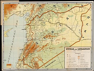
[edit]| Syria and Lebanon
( |
||||||||||||||||||||||||
|---|---|---|---|---|---|---|---|---|---|---|---|---|---|---|---|---|---|---|---|---|---|---|---|---|
| Title |
Syria and Lebanon |
|||||||||||||||||||||||
| Publisher |
K.Arzoumanian |
|||||||||||||||||||||||
| Description |
Syria and Lebanon.. |
|||||||||||||||||||||||
| Language | English | |||||||||||||||||||||||
| Publication date | 1935 possibly | |||||||||||||||||||||||
| Medium | 1 sheet : color ; | |||||||||||||||||||||||
| Dimensions | height: 46 cm (18.1 in); width: 62 cm (24.4 in) | |||||||||||||||||||||||
| Collection |
|
|||||||||||||||||||||||
| Current location |
|
|||||||||||||||||||||||
| Place of publication | Cairo | |||||||||||||||||||||||
| search Merhav catalog | Cairo | |||||||||||||||||||||||
| Notes | ||||||||||||||||||||||||
| scale | 1:1,200,000 cm | |||||||||||||||||||||||
| IE PID | IE155196786 | |||||||||||||||||||||||
| Rosetta filename | FL155196788 | |||||||||||||||||||||||
| NNL item ID (P3959) | 990039267580205171 | |||||||||||||||||||||||
| Depicts | Syria – sovereign state in western Asia | |||||||||||||||||||||||
| search Merhav catalog | Syria, English | |||||||||||||||||||||||
| search Merhav catalog | SyriaLebanonK.Arzoumanian | |||||||||||||||||||||||
| Source/Photographer |
|
|||||||||||||||||||||||
| Other versions | ||||||||||||||||||||||||
| Jpg / Tif version |
|
|||||||||||||||||||||||

.jpg)

.jpg&action=edit§ion=1)
Licensing
[edit].jpg&action=edit§ion=2)
This UK artistic or literary work, of which the author is unknown and cannot be ascertained by reasonable enquiry, is in the public domain because it is one of the following:
|
 |
File history
Click on a date/time to view the file as it appeared at that time.
| Date/Time | Thumbnail | Dimensions | User | Comment | |
|---|---|---|---|---|---|
| current | 11:33, 2 September 2023 | | 14,912 × 11,214 (187.77 MB) | Geagea (talk | contribs) | pattypan 22.03 |
You cannot overwrite this file.
File usage on Commons
The following page uses this file:
.jpg&oldid=887036663)