File:Syr Darya Oblast. Ruins of the Mulushki Mirza Rabat Near Khodzhend WDL3889.png
Jump to navigation
Jump to search
Size of this preview: 800 × 561 pixels. Other resolutions: 320 × 224 pixels | 640 × 449 pixels | 1,024 × 718 pixels | 1,280 × 897 pixels | 1,461 × 1,024 pixels.
Original file (1,461 × 1,024 pixels, file size: 2.06 MB, MIME type: image/png)
Captions
Captions
Add a one-line explanation of what this file represents
Summary
[edit]
| Author |
Русский: Богаевский, Николай Владимирович, 1843—1912 гг.
Français : Bogaevskii, Nikolaï V., 1843-1912
English: Bogaevskii, Nikolai V., 1843-1912
中文:亚历山大·L·坤,1840-1888 年
Português: Bogaevskii, Nikolai V., 1843-1912
العربية: بوغافسكي، نيكولاي ف.، 1843-1912
Español: Bogaevskii, Nikolai V., 1843-1912 |
| Title |
Русский: Сырдарьинская область. Развалины рабата Мулушки-мирзы близ Ходжента
Français : Oblast de Syr-Daria. Ruines du rabat de Mulushki Murza à proximité de Khodjend
English: Syr Darya Oblast. Ruins of the Mulushki Mirza Rabat Near Khodzhend
中文:锡尔河地区苦盏附近的穆路什基·米尔扎拉巴特遗址
Português: Oblast de Sir Dária. Ruínas do rabat de Mulushki Murza próximo a Khodzhend
العربية: منطقة سير داريا. أطلال رَباط ميليشكي ميرزا بالقرب من خوجاند
Español: Óblast de Sir Daria. Ruinas del rabat de Mulushki Murza cerca de Khodjent |
| Description |
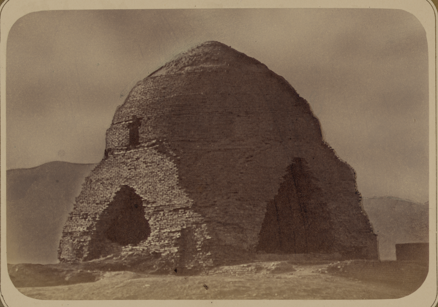
Русский: Эта фотография развалин рабата, построенного Мулушки-мурзой неподалеку от Худжанда (современный Таджикистан), содержится в археологической части "Туркестанского альбома". Шеститомное фотографическое исследование было подготовлено и издано в 1871—1872 гг. под патронажем генерала Константина П. фон Кауфмана, первого генерал-губернатора (1867—1882 гг.) Туркестана, как называли в то время территорию Центральной Азии, принадлежавшую Российской империи. Город Худжанд, расположенный на реке Сырдарья, был заложен в конце VI в. до н. э. персидским царем Киром Великим, основателем империи Ахеменидов, и изначально назывался Кирополисом. По всей вероятности, в 329 году до н. э. город был повторно укреплен Александром Великим. В VIII в. Худжанд, представлявший собой важную точку на Великом шелковом пути, был завоеван арабами. К X в. он входил в состав империи Саманидов. В 1220 г. Худжанд был разграблен монголами, а в конце XIV — XV вв. восстановлен под властью Тимуридов. В XVI в. город находился под управлением династии Шейбанидов из Бухарского ханства и оставался под контролем Бухары до включения в состав Кокандского ханства (1802 г.). В 1866 г. он был взят российскими войсками. Термин "рабат" имеет несколько толкований, которые в целом сводятся к обозначению укрепленной заставы (по употреблению близок к термину "рибат"). В Центральной Азии "рабат" также соотносится с термином "ханака", обозначающим гостиницу или место для духовного уединения. Только центральная часть под куполом сохранилась от древнего рабата, показанного на фотографии. О создателе этого сооружения известно немногое, однако следует отметить, что титул "мурза" использовался для почетного именования представителей татарской аристократии второго уровня.
Археологические объекты; Фотографические исследования Français : Cette photographie des ruines d’un rabat construit par Mulushki Murza à proximité de Khodjend (dans l’actuel Tadjikistan) est extraite de l’ouvrage archéologique Album du Turkestan. Cet inventaire photographique, en six volumes, fut réalisé entre 1871 et 1872 sous le patronage du général Konstantin P. von Kaufman, premier gouverneur général (1867-1882) du Turkestan, nom donné aux territoires d'Asie centrale de l'Empire russe. Khodjend, située sur le fleuve Syr Daria, a été fondée comme Cyropolis, à la fin du VIe siècle avant J.-C. par le roi perse Cyrus le Grand, fondateur de l'Empire achéménide. Le site a été apparemment fortifié à nouveau par Alexandre le Grand en 329 avant J.-C. Située le long de la route de la soie, Khodjend a été prise par les Arabes au VIIIe siècle. Au Xe siècle, elle passa sous le contrôle des Samanides. Saccagée par les Mongols en 1220, Khodjend connut un regain d’intérêt sous le règne des Timourides à la fin du XIVe et durant le XVe siècle. Au XVIe siècle, elle fut gouvernée par la dynastie des Chaybanides à Boukhara et elle resta sous le contrôle de Boukhara jusqu’à son absorption par le khanat de Kokand en 1802. Elle a été prise par les forces russes en 1866. Le terme « rabat » a différentes interprétations qui indiquent généralement un avant-poste fortifié (un usage similaire au terme ribat). En Asie centrale, le rabat est également lié au terme khanaka, qui désigne un foyer ou un lieu de retraite spirituelle. De l’ancien rabat illustré ici, seule la structure centrale en forme de dôme subsiste. On sait peu de choses de son fondateur, à part que « murza » était un terme honorifique pour la noblesse tatare secondaire.
Sites archéologiques; Inventaires photographiques English: This photograph of the ruins of a rabat built by Mulushki Mirza near Khodzhend (in present-day Tajikistan) is from the archeological part of Turkestan Album. The six-volume photographic survey was produced in 1871–72 under the patronage of General Konstantin P. von Kaufman, the first governor-general (1867–82) of Turkestan, as the Russian Empire’s Central Asian territories were called. Located on the Syr Darya River, Khodzhend was settled as Cyropolis in the late 6th century BC by the Persian king Cyrus the Great, founder of the Achaemenid Empire. The site was apparently refortified by Alexander the Great in 329 BC. A strong point along the Silk Road, Khujand was taken by the Arabs in the 8th century. By the 10th century it belonged to the Samanid Empire. Sacked by the Mongols in 1220, Khodzhend revived under the Timurids in the late 14th and 15th centuries. In the 16th century it was ruled by the Shaybanid dynasty in Bukhara and remained under control of Bukhara until absorbed by the Kokand Khanate in 1802. In 1866 it was taken by Russian forces. The term “rabat” has various interpretations that imply a fortified outpost (a usage similar to the term ribat). In Central Asia rabat is also linked to the term khanaka, a hostel or place for spiritual retreat. Of the ancient rabat shown here, only the central domed structure remains. Little is known of the builder, but “mirza” was an honorific term for secondary Tatar nobility.
Archaeological sites; Photographic surveys 中文:这张照片出自《土耳其斯坦相册》的考古部分,展示的是穆路什基·穆尔扎 (Mulushki Murza) 在苦盏(今塔吉克斯坦)附近建造的拉巴特 (rabat) 的遗址。这份六卷本摄影调查作品制作于 1871-1872 年间,是在俄罗斯驻土耳其斯坦(俄罗斯帝国中亚属地的名称)的首任总督康斯坦丁·P·凡·考夫曼(Konstantin P. von Kaufman,1867-1882 年在位)赞助下完成的。苦盏位于锡尔河上,公元前 6 世纪后期,阿契美尼德帝国的创建者波斯国王居鲁士大帝 (Cyrus the Great) 在此建造了居罗波利斯(Cyropolis,意为“居鲁士之城”)。显然在公元前 329 年,亚历山大大帝对这个地方进行了加固。作为丝绸之路上一个重要的据点,苦盏在公元 8 世纪被阿拉伯人夺取。到了 10 世纪,这里成为萨曼帝国的一部分。1220 年苦盏被蒙古人洗劫,14 世纪后期和 15 世纪帖木尔统治时期得以恢复生机。16 世纪,它被由布哈拉的昔班尼王朝统治,此后一直被布哈拉控制,直到 1802 年被浩罕汗国吞并。1866 年,它被俄国军队攻陷。拉巴特这个词有多种不同的解释,通常指一个坚固的前哨(用法与词语 ribat 类似)。在中亚,拉巴特与 khanaka(纪念性建筑群)这个词有关,是精神静修的旅舍或住处。照片中显示的古老拉巴特中,只有中间的圆顶建筑仍然存在。其建造者是谁目前尚不清楚,但“穆尔扎”(murza) 是对鞑靼次要贵族的尊称。
考古遗址; 摄影勘察作品 Português: Esta fotografia das ruínas de um rabat construído por Mulushki Murza próximo a Khujand (atual Tajiquistão), faz parte da seção arqueológica do Álbum do Turquestão. Este levantamento fotográfico em seis volumes foi produzido entre 1871-1872 sob o patrocínio do General Konstantin P. von Kaufman, primeiro governador-geral (1867-1882) do Turquestão, nome dado aos territórios da Ásia Central do Império Russo. Localizada no rio Sir Dária, Khujand foi fundada como Cirópolis no final do século VI a.C. pelo rei persa Ciro, o Grande, fundador do Império Acmênida. O local aparentemente foi refortificado por Alexandre, o Grande, em 329 a.C.. Ponto forte da Rota da Seda, Khujand foi tomada pelos árabes no século VIII. No século X fazia parte do Império Samanida. Saqueada pelos mongóis em 1220, Khujand reviveu sob os timúridas no final do século XIV e século XV. No século XVI, foi governada pela dinastia shaybanida de Bucara, e permaneceu sob o controle de Bucara até ser absorvida pelo canato de Kokand em 1802. Em 1866 foi tomada pelas forças russas. O termo “rabat” tem diversas interpretações que indicam um posto avançado fortificado (um uso semelhante ao do termo ribat). Na Ásia Central, rabat também está ligado ao termo khanaka, um alojamento de peregrinos ou local de retiro espiritual. Do antigo rabat mostrado aqui resta somente a estrutura da cúpula central. Pouco se sabe sobre seu construtor, mas “murza” era um termo honorífico para nobres tártaros secundários.
Sítios arqueológicos; Levantamentos fotográficos العربية: تُوجد هذه الصورة ضمن الجزء الأثري من ألبوم تُرْكِستان، وهي تُظهر أطلال رَباط بناه ميليشكي ميرزا بالقرب من خوجاند (في ما تسمى حاليًا بطاجيكستان). تم إصدار البحث التصويري المكوّن من ستة مجلدات بين العامين 1871-1872 تحت رعاية الجنرال كونستانتين ب. فون كوفمان، الحاكم العام الأول لتُرْكِستان (1867-1882)، وهو ما كان يُطلق على أراضي وسط آسيا التابعة للإمبراطورية الروسية. أسس الملك الفارسي سايرس الأكبر، مؤسس الإمبراطورية الأخمينية، خوجاند على نهر سير داريا في أواخر القرن السادس قبل الميلاد، وكانت تعرف آنذاك باسم سايروبوليس. أعاد الإسكندر الأكبر تحصين الموقع على ما يبدو في عام 329 قبل الميلاد. فتح العرب خوجاند في القرن الثامن نسبةً لموقعها الحيوي على امتداد طريق الحرير. وبحلول القرن العاشر، سيطرت الإمبراطورية السامانية عليها. نهب خوجاند المغول في عام 1220، إلا أنه أُعيد إحياؤها تحت حكم التيموريين في أواخر القرن الرابع عشر والقرن الخامس عشر. كما أنها خضعت لحكم الأسرة الشيبانيانية من بخارى في القرن السادس عشر وظلت في قبضة بخارى حتى انضمت إلى خانات قوقند في عام 1802. وفي عام 1866، استولت القوات الروسية عليها. لمصطلح الرباط تفسيرات مختلفة تعني عمومًا ثغراً مُحصنًا (وهو استخدام مشابهه لمصطلح رِباط). في آسيا الوسطى، يرتبط مصطلح الرباط بمصطلح خانكة، وهو نُزل أو مكان للاعتزال الروحي. لم يتبق من الرباط القديم، الذي يظهر هنا، سوى الهيكل المقبب المركزي. لا يُعرف عن المعماري الذي بناه سوى القليل، لكن "ميرزا" الواردة في الاسم هي لقبٌ شرفي لطبقة النبالة التتارية الثانوية.
المواقع الأثرية; البحوث التصويرية Español: Esta fotografía de las ruinas de un rabat construido por Mulushki Murza cerca de Khodjent (actual Tayikistán) pertenece a la parte arqueológica del Álbum de Turquestán. El estudio fotográfico en seis volúmenes se produjo entre 1871 y 1872, bajo el patrocinio del general Konstantín P. von Kaufman, el primer gobernador general (1867-1882) de Turquestán, como se conocían a los territorios del Imperio ruso en Asia Central. Khodjent, situada junto al río Sir Daria, fue fundada como Cirópolis a finales del siglo VI a. C. por el rey persa Ciro el Grande, fundador del Imperio aqueménida. Al parecer, Alejandro Magno volvió a fortificar el lugar en el 329 a. C. Khodjent era un punto fuerte en la Ruta de la seda y fue tomada por los árabes en el siglo VIII. Para el siglo X, pertenecía al Imperio samánida. Khodjent fue saqueada por los mongoles en 1220 y revivió bajo la dinastía timúrida a finales del siglo XIV y en el XV. En el siglo XVI estuvo gobernada por la dinastía shaybánida en Bújara y permaneció bajo el control de Bújara hasta que la absorbió el kanato de Kokand en 1802. En 1866 fue tomada por las fuerzas rusas. El término «rabat» tiene varias interpretaciones, que implican un puesto fortificado (uso similar al del término rábida). En Asia Central, rabat también está vinculado con el término khanaka: un hospedaje para peregrinos o lugar para el retiro espiritual. Del antiguo rabat que se muestra aquí solo queda la estructura central con cúpula. Se sabe poco sobre su constructor, pero «murza» era un término honorífico para la nobleza tártara secundaria.
Sitios arqueológicos; Estudios fotográficos |
| Date | between 1865 and 1872 |
| Medium |
Русский: Эстампы, фотографии
Français : Images, photographies
English: Prints, Photographs
中文:图像, 摄影作品
Português: Imagens, Fotografias
العربية: مطبوعات، صور فوتوغرافية
Español: Imágenes, Fotografías |
| Dimensions |
English: 1 photographic print : albumen |
| Collection |
Русский: Библиотека Конгресса
Français : Bibliothèque du Congrès
English: Library of Congress
中文:国会图书馆
Português: Biblioteca do Congresso
العربية: مكتبة الكونغرس
Español: Biblioteca del Congreso |
| Current location |
Русский: Изображения из "Туркестанского альбома"
Français : Images de l'Album du Turkestan
English: Images from the Turkestan Album
中文:图片出自《土耳其斯坦相册》
Português: Imagens do Álbum do Turquestão
العربية: صور من ألبوم تُرْكِستان
Español: Imágenes del Álbum de Turquestán |
| Place of creation |
Русский: Таджикистан
Français : Tadjikistan
English: Tajikistan
中文:塔吉克斯坦
Português: Tajiquistão
العربية: طاجكستان
Español: Tayikistán |
| Notes |
Original language title: Сыр-дарьинская область. Развалины Мулушки Мурза Рабат близ г. Ходженда Русский: Иллюстрация в: Туркестанский альбом, Часть археологическая, 1871–1872 гг., часть 1, том 1, пластина 13.
Français : Illustration provenant de : Album du Turkestan, ouvrage archéologique, 1871-1872, partie 1, volume 1, planche 13.
English: Illustration in: Turkestan Album, Archaeological Part, 1871-1872, part 1, volume 1, plate 13.
中文:插图出自:《土耳其斯坦相册》,考古部分,1871-1872 年,第 1 部分,第 1 卷,第 13 页。
Português: Ilustração em: Álbum do Turquestão, seção arqueológica, 1871-1872, parte 1, volume 1, placa 13.
العربية: رسم إيضاحي في: ألبوم تُرْكِستان، الجزء الأثري، 1871-1872، الجزء الأول، المجلد الأول، اللوحة 13.
Español: Ilustración en: Álbum de Turquestán, parte arqueológica, 1871-1872, parte 1, volumen 1, lámina 13. |
| References | http://hdl.loc.gov/loc.wdl/dlc.3889 |
| Source/Photographer |
|
Licensing
[edit]
|
This is a faithful photographic reproduction of a two-dimensional, public domain work of art. The work of art itself is in the public domain for the following reason:
The official position taken by the Wikimedia Foundation is that "faithful reproductions of two-dimensional public domain works of art are public domain".
This photographic reproduction is therefore also considered to be in the public domain in the United States. In other jurisdictions, re-use of this content may be restricted; see Reuse of PD-Art photographs for details. | ||||
File history
Click on a date/time to view the file as it appeared at that time.
| Date/Time | Thumbnail | Dimensions | User | Comment | |
|---|---|---|---|---|---|
| current | 15:19, 2 March 2014 | | 1,461 × 1,024 (2.06 MB) | Fæ (talk | contribs) | =={{int:filedesc}}== {{Artwork |artist = |author ={{ru|1=Богаевский, Николай Владимирович, 1843—1912 гг.}} {{fr|1=Bogaevskii, Nikolaï V., 1843-1912}} {{en|1=Bogaevskii, Nikolai V., 1843-1912}} {{zh|1=亚历山大·L... |
You cannot overwrite this file.
File usage on Commons
The following page uses this file: