File:Sypniewo (gmina) location map.png
Jump to navigation
Jump to search

Size of this preview: 645 × 599 pixels. Other resolutions: 258 × 240 pixels | 517 × 480 pixels | 970 × 901 pixels.
Original file (970 × 901 pixels, file size: 154 KB, MIME type: image/png)
Captions
Captions
Add a one-line explanation of what this file represents
| Description |
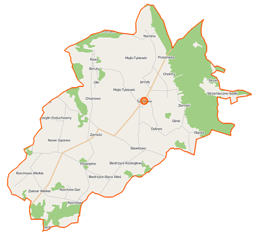
Polski: Mapa gminy Sypniewo, Polska
English: Map of Gmina Sypniewo, Poland |
|||||||||
| Date | ||||||||||
| Source | You may find a page on the OpenStreetMap wiki page for Sypniewo (gmina) | |||||||||
| Creator |
OpenStreetMap contributors OpenStreetMap contributors |
|||||||||
| Permission (Reusing this file) |
OpenStreetMap data is available under the Open Database License (details). Map tiles are licensed under the Creative Commons Attribution-ShareAlike 2.0 license (CC-BY-SA 2.0).
This file is licensed under the Creative Commons Attribution-Share Alike 2.0 Generic license.
|
|||||||||
| Geotemporal data | ||||||||||
| Bounding box |
|
|||||||||
| Georeferencing | If inappropriate please set warp_status = skip to hide. | |||||||||
File history
Click on a date/time to view the file as it appeared at that time.
| Date/Time | Thumbnail | Dimensions | User | Comment | |
|---|---|---|---|---|---|
| current | 10:48, 12 September 2014 | | 970 × 901 (154 KB) | VanWiel (talk | contribs) | {{Information |Description= |Source= |Date= |Author= |Permission= |other_versions= }} |
| 04:52, 6 August 2014 |  | 970 × 901 (168 KB) | VanWiel (talk | contribs) | {{OpenStreetMap | name = Sypniewo (gmina) | location = Sypniewo (gmina) | description = {{pl|Mapa gminy Sypniewo, Polska}} {{en|Map of Gmina Sypniewo, Poland}} | top = 53.0695 | left = 21.1593 | r... |
You cannot overwrite this file.
File usage on Commons
There are no pages that use this file.
File usage on other wikis
The following other wikis use this file:
- Usage on fr.wikipedia.org
- Usage on pl.wikipedia.org
- Sypniewo (gmina)
- Batogowo
- Biedrzyce-Koziegłowy
- Biedrzyce-Stara Wieś
- Gąsewo Poduchowne
- Glącka
- Glinki-Rafały
- Jarzyły
- Majki-Tykiewki
- Mamino
- Nowe Gąsewo
- Nowy Szczeglin
- Olki
- Rawy
- Rzechowo-Gać
- Rzechowo Wielkie
- Rzechówek
- Szczeglin Poduchowny
- Stare Glinki
- Strzemieczne-Sędki
- Ziemaki (województwo mazowieckie)
- Chełchy (województwo mazowieckie)
- Sypniewo (województwo mazowieckie)
- Chojnowo (powiat makowski)
- Dylewo (powiat makowski)
- Poświętne (powiat makowski)
- Sławkowo (powiat makowski)
- Zalesie (gmina Sypniewo)
- Zamość (powiat makowski)
- Boruty (gmina Sypniewo)
- Parafia św. Jana Chrzciciela w Sypniewie
- Gutowo (województwo mazowieckie)
- Moduł:Mapa/dane/Sypniewo (gmina)
- Parafia św. Małgorzaty w Gąsewie Poduchownym
- Usage on pl.wikibooks.org
_location_map.png&oldid=450060838)