File:Switzerland ESA370220.jpg
Original file (4,000 × 2,827 pixels, file size: 15.05 MB, MIME type: image/jpeg)
Captions
Captions
Summary
[edit]| Description |
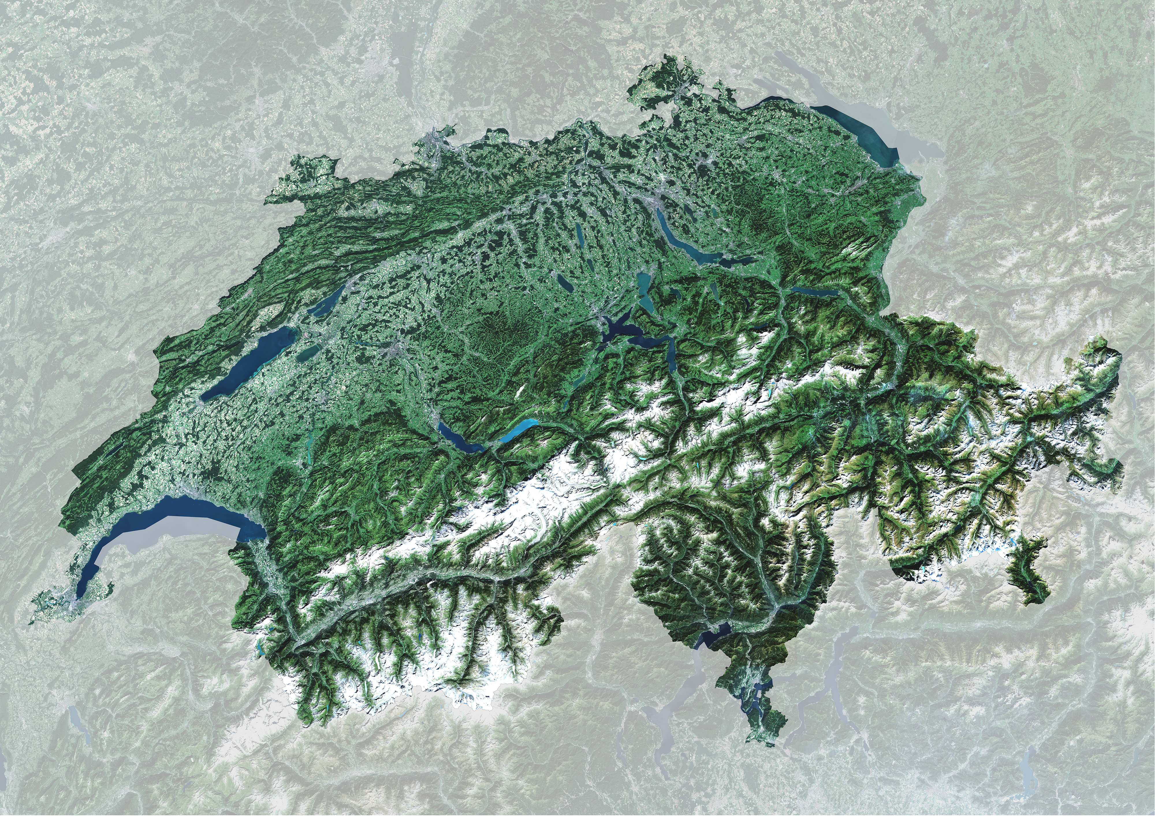
English: Multiple scans from the Copernicus Sentinel-2A satellite have been stitched together to create this complete image of Switzerland. Nota Bene: this is a reduced JPEG version of the original TIFF file. Click on the box in the lower-right corner to view this image at its full 10 m resolution.
The southern part of the country is dominated by the Alps, some of which are snow-capped. One of the more obvious features in the lower central part of the image is the curved x-shape of the Aletsch Glacier, the largest in the Alps. Owing to climate change, the glaciers in this region are showing long-term retreat. North of the Alps, the landscape descends into the Central Plateau, which covers about a third of Switzerland and is home to major cities like Zurich and the de facto capital city, Bern. It is the most densely populated region and hosts the majority of the country’s industry, manufacturing and farming. Along the northwestern edge of the country are the Jura mountains, consisting of a sequence of ‘folds’ in the geology, visible in the image as linear ridges running roughly southwest to northeast. Switzerland has thousands of lakes shaped by glaciers during the last ice age, about 15 000 years ago. Lake Geneva in the west is shared with France, while Lake Constance in the east is shared with Germany and Austria, making Lake Neuchâtel in the northwest the largest entirely within Switzerland. The lakes appear different colours owing to variations in algae content or to the presence of finely ground rock flowing in from the mountain glaciers. Near the centre of the country we can see Lake Lucerne with its four ‘arms’. The city of Lucerne sits on the western end of the lake, and is the site of the latest ESA ministerial council. Held on 1–2 December, ministers in charge of space activities from the 22 ESA Member States will meet to decide on Europe’s space activities. ESA is proposing the next-generation scientific Earth observation programme at the council, focusing on the development of new satellites to address global challenges. Other proposals address a smaller satellite for monitoring ozone in the stratosphere, the provision of essential data for climate research, and public–private partnerships. This image is featured on the Earth from Space video programme. |
| Date | |
| Source | http://www.esa.int/spaceinimages/Images/2016/12/Switzerland |
| Author | European Space Agency |
| Permission (Reusing this file) |
contains modified Copernicus Sentinel data (2016), processed by GeoVille,CC BY-SA 3.0 IGO |
| Other versions |
|
| Title | Switzerland |
| Set | Earth observation image of the week |
| System | Copernicus |
| Mission | Sentinel-2 |
| Location | Switzerland |
| Activity | Observing the Earth |
| Keywords | Satellite image |

Licensing
[edit]
- You are free:
- to share – to copy, distribute and transmit the work
- to remix – to adapt the work
- Under the following conditions:
- attribution – You must give appropriate credit, provide a link to the license, and indicate if changes were made. You may do so in any reasonable manner, but not in any way that suggests the licensor endorses you or your use.
- share alike – If you remix, transform, or build upon the material, you must distribute your contributions under the same or compatible license as the original.

|
This image contains data from a satellite in the Copernicus Programme, such as Sentinel-1, Sentinel-2 or Sentinel-3. Attribution is required when using this image.
Attribution: Contains modified Copernicus Sentinel data {{{year}}}
The use of Copernicus Sentinel Data is regulated under EU law (Commission Delegated Regulation (EU) No 1159/2013 and Regulation (EU) No 377/2014). Relevant excerpts:
Free access shall be given to GMES dedicated data [...] made available through GMES dissemination platforms [...].
Access to GMES dedicated data [...] shall be given for the purpose of the following use in so far as it is lawful:
GMES dedicated data [...] may be used worldwide without limitations in time.
GMES dedicated data and GMES service information are provided to users without any express or implied warranty, including as regards quality and suitability for any purpose. |
File history
Click on a date/time to view the file as it appeared at that time.
| Date/Time | Thumbnail | Dimensions | User | Comment | |
|---|---|---|---|---|---|
| current | 08:04, 7 May 2017 | | 4,000 × 2,827 (15.05 MB) | Fæ (talk | contribs) | European Space Agency, Id 370220, http://www.esa.int/spaceinimages/Images/2016/12/Switzerland, User:Fæ/Project_list/ESA |
You cannot overwrite this file.
File usage on Commons
The following page uses this file:
File usage on other wikis
The following other wikis use this file:
- Usage on de.wikipedia.org
- Usage on fr.wikipedia.org
- Usage on ku.wikipedia.org
- Usage on rm.wikipedia.org