File:Sweden Blekinge relief location map.png
Jump to navigation
Jump to search

Size of this preview: 800 × 398 pixels. Other resolutions: 320 × 159 pixels | 640 × 319 pixels | 1,500 × 747 pixels.
Original file (1,500 × 747 pixels, file size: 1.24 MB, MIME type: image/png)
Captions
Captions
Add a one-line explanation of what this file represents
Summary
[edit]
| Description |
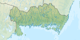
English: Location map of Blekinge in Sweden
Equirectangular projection, N/S stretching 182 %. Geographic limits of the map:
|
| Date | |
| Source |
Own work
|
| Author | Silverkey (Mickaël Delcey) |
Licensing
[edit]
I, the copyright holder of this work, hereby publish it under the following license:
This file is licensed under the Creative Commons Attribution-Share Alike 4.0 International license.
- You are free:
- to share – to copy, distribute and transmit the work
- to remix – to adapt the work
- Under the following conditions:
- attribution – You must give appropriate credit, provide a link to the license, and indicate if changes were made. You may do so in any reasonable manner, but not in any way that suggests the licensor endorses you or your use.
- share alike – If you remix, transform, or build upon the material, you must distribute your contributions under the same or compatible license as the original.
File history
Click on a date/time to view the file as it appeared at that time.
| Date/Time | Thumbnail | Dimensions | User | Comment | |
|---|---|---|---|---|---|
| current | 21:59, 23 April 2017 | | 1,500 × 747 (1.24 MB) | Silverkey (talk | contribs) | Add bathymetry + better coastline |
| 19:44, 3 February 2017 |  | 1,501 × 747 (1.19 MB) | Silverkey (talk | contribs) | Fix size and borders | |
| 19:18, 3 February 2017 |  | 1,333 × 664 (990 KB) | Silverkey (talk | contribs) | Double the resolution | |
| 19:16, 3 February 2017 |  | 667 × 332 (282 KB) | Silverkey (talk | contribs) | User created page with UploadWizard |
You cannot overwrite this file.
File usage on Commons
There are no pages that use this file.
File usage on other wikis
The following other wikis use this file:
- Usage on da.wikipedia.org
- Usage on en.wikipedia.org
- Usage on es.wikipedia.org
- Usage on fr.wikipedia.org
- Usage on ja.wikipedia.org
- Usage on ml.wikipedia.org
- Usage on no.wikipedia.org
- Usage on os.wikipedia.org
- Usage on sco.wikipedia.org
- Usage on simple.wikipedia.org
- Usage on si.wikipedia.org
- Usage on sv.wikipedia.org
- Örlogsstaden Karlskrona
- Raslången
- Halen
- Mall:Kartposition Blekinge
- Melesjön
- Grundsjön, Ryssberget
- Salsjön, Blekinge
- Sidlången
- Abborragyl (Ringamåla socken, Blekinge)
- Abborragylet (Ringamåla socken, Blekinge, 624325-144143)
- Abborragylet (Ringamåla socken, Blekinge, 624694-143580)
- Abborresjön, Blekinge
- Agnegylet
- Agnsjön (Asarums socken, Blekinge)
- Anglasjön
- Askegylet
- Avundsgyl
- Björkesjön (Hällaryds socken, Blekinge)
- Björkesjön (Asarums socken, Blekinge)
- Björngylet
- Bredagyl (Asarums socken, Blekinge)
- Bredagyl (Ringamåla socken, Blekinge)
- Brogylet
- Bruksgylet
- Bråtasjön, Blekinge
- Brötagylet
- Buasjögyl
- Buasjön, Blekinge
- Byasjön (Asarums socken, Blekinge)
- Bökegyl (Asarums socken, Blekinge, 623626-144285)
View more global usage of this file.