File:Svratouch, CZ180419-024.jpg
Jump to navigation
Jump to search

Size of this preview: 800 × 464 pixels. Other resolutions: 320 × 185 pixels | 640 × 371 pixels | 1,024 × 594 pixels | 1,280 × 742 pixels | 2,560 × 1,484 pixels | 4,675 × 2,710 pixels.
Original file (4,675 × 2,710 pixels, file size: 3.29 MB, MIME type: image/jpeg)
Captions
Captions
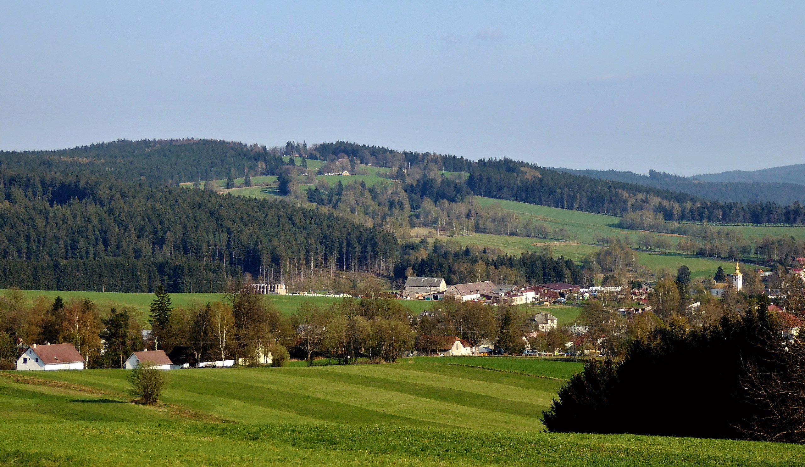
The top of Karlštejn hill above the village Svratouch.
Summary
[edit]
| Description |
English: The mighty hill above the village of Svratouch, with the local name Karlštejn and the peak at an altitude of 784 m (according to the contour map), the trigonometric point with a elevation 783.4 m, several tens of meters from the peak in the forest. In the top part of the hill is the settlement location Karlštejn (part of the village Svratouch) and originally a hunting chateau of the same name, built in 1770-1776 in the late Baroque style. A local road leads from the center of Svratouch to the top, the end of the path at the chateau object. The peak is the highest point on the Earth's surface in the geomorphological district of "Borovský" forest , in the regional divide of the georelief is part of Žďárské vrchy, in the north-western part of the "Hornosvratecká" highlands (geomorphological whole). Summary from the Czech description. Photo-location: Czechia, Pardubice Region, the village of "Svratouch", meadows below the peak "U oběšeného", distance 4 km (azimuth 120°).
Čeština: Mohutný vrch nad obcí Svratouch, s místním názvem Karlštejn a vrcholem v nadmořské výšce 784 m (dle vrstevnicové mapy), trigonometrický bod s kótou 783,4 m n. m. několik desítek metrů od vrcholu v lesním porostu. Ve vrcholové části sídelní lokalita Karlštejn (část obce Svratouch) a původně lovecký zámek stejného jména, postavený v letech 1770–1776 v pozdně barokním stylu. Na vrchol vedena místní zpevněná silniční komunikace z centra obce, ukončená před objektem zámku. Vrchol je nejvyšším bodem na zemském povrchu v geomorfologickém okrsku Borovský les, v regionálním členění georeliéfu je součástí Žďárských vrchů, geomorfologického podcelku v severozápadní oblasti Hornosvratecké vrchoviny (geomorfologický celek). V rozsahu celé plochy je kopec zvláště chráněným územím, od roku 1970 součástí Chráněné krajinné oblasti Žďárské vrchy a od roku 1978 také chráněné oblasti přirozené akumulace vod na severovýchodě Českomoravské vrchoviny. Foto-lokace: Česko, Pardubický kraj, obec Svratouch, louka pod vrcholem U oběšeného, vzdálenost 4 km (azimut 120°). |
| Date | |
| Source | Own work |
| Author | Josef Kreuz (PEPan) |
| Camera location | | View this and other nearby images on: OpenStreetMap |
|---|
Faktografie:
[edit]
Vrchol v zalesněné části na fotografii vlevo, ve vrcholové části lovecký zámeček Karlštejn (čp. 1), níže louky a zástavba v sídelní lokalitě Karlštejn, vpravo na svahu golfové hřiště (Golf Club Svratka 1932), dole zástavba v obci Svratouch, zcela vpravo věž evangelického kostela v centrální části obce. Pod vrcholem vlevo zalesněná lokalita Borovina s vrcholem 723 m n. m. nad Svratouchem.
Zdroje informací:
[edit]
- AOPK ČR, chráněné krajinné oblasti – CHKO Žďárské vrchy, viz
- AOPK ČR, mapová aplikace – přírodní poměry, viz
- AOPK ČR, chráněná území – přírodní památka Zkamenělý zámek, viz
- ČHMÚ, evidence rozvodnic – orografická rozvodnice řeky Svratky, viz archive copy at the Wayback Machine
- ČGS, geovědní mapy – kompozice Svratouch / Karlštejn, viz
- ČGS, geologické lokality – rašeliniště Karlštejn, viz
- ČÚZK, základní mapa Česka – obec Svratouch a okolí, viz
- NPÚ ČR, památkový katalog – lovecký zámeček, viz
- Svratouch, obec – webové stránky, viz
Licensing
[edit]
I, the copyright holder of this work, hereby publish it under the following license:
This file is licensed under the Creative Commons Attribution-Share Alike 4.0 International license.
- You are free:
- to share – to copy, distribute and transmit the work
- to remix – to adapt the work
- Under the following conditions:
- attribution – You must give appropriate credit, provide a link to the license, and indicate if changes were made. You may do so in any reasonable manner, but not in any way that suggests the licensor endorses you or your use.
- share alike – If you remix, transform, or build upon the material, you must distribute your contributions under the same or compatible license as the original.
File history
Click on a date/time to view the file as it appeared at that time.
| Date/Time | Thumbnail | Dimensions | User | Comment | |
|---|---|---|---|---|---|
| current | 11:42, 6 May 2018 | | 4,675 × 2,710 (3.29 MB) | PEPan (talk | contribs) | User created page with UploadWizard |
You cannot overwrite this file.
File usage on Commons
There are no pages that use this file.
File usage on other wikis
The following other wikis use this file:
- Usage on cs.wikipedia.org
- Usage on eo.wikipedia.org