File:Svratouch, CZ180407-054.jpg
Jump to navigation
Jump to search

Size of this preview: 800 × 447 pixels. Other resolutions: 320 × 179 pixels | 640 × 358 pixels | 1,024 × 572 pixels | 1,280 × 715 pixels | 2,560 × 1,430 pixels | 4,822 × 2,694 pixels.
Original file (4,822 × 2,694 pixels, file size: 4.15 MB, MIME type: image/jpeg)
Captions
Captions
Add a one-line explanation of what this file represents
Summary
[edit]
| Description |
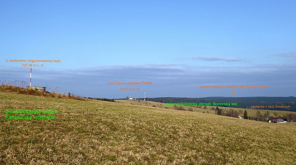
English: View of the trigonometric point of "U oběšeného" with altitude of 737.38 m and remote hill of Otava (734,5 m asl.) above the village of Svratouch. Above the wooded ridge of the geomorphological district of "Borovský" forest is the upper part of the radiocommunication tower, lies at the top of the hill (765,5 asl.), with czech name: Spálený kopec. Geographical name in czech written form "U oběšeného" is the standard name of the geographic object of hill type. The highest peak of the Iron Mountains lies in the south-eastern part of the mountain range with name "Sečská" Highlands, in the geomorphological district "Kameničská" Highlands. In the photo is orientative the czech labels of the height points (orange). Photo-location: Czechia, Pardubice Region, the village of "Svratouch", southern slope of the peak of "U oběšeného".
Sources of information:
Čeština: Pohled na trigonometrický bod U oběšeného s nivelací 737,38 m n. m. a vzdálený vrch Otava (734,5 m n. m.) nad obcí Svratouch. Nad zalesněným hřbetem geomorfologického okrsku Borovský les je horní část radiokomunikační věže na vrcholu Spálený kopec (765,5 m n. m.). Zeměpisný název (oronymum) v písemné podobě U oběšeného je standardizované jméno geografického objektu typu kopce. Nejvyšší vrchol Železných hor leží v jihovýchodní části pohoří nazvané Sečská vrchovina, na okraji geomorfologického okrsku Kameničská vrchovina. Na fotografii orientační popisky výškových bodů (oranžová). Foto-lokace: Česko, Pardubický kraj, obec Svratouch, jižní svah vrcholu U oběšeného. (80°).
Zdroje informací:
|
| Date | |
| Source | Own work |
| Author | Josef Kreuz (PEPan) |
| Camera location | | View this and other nearby images on: OpenStreetMap |
|---|
Licensing
[edit]
I, the copyright holder of this work, hereby publish it under the following license:
This file is licensed under the Creative Commons Attribution-Share Alike 4.0 International license.
- You are free:
- to share – to copy, distribute and transmit the work
- to remix – to adapt the work
- Under the following conditions:
- attribution – You must give appropriate credit, provide a link to the license, and indicate if changes were made. You may do so in any reasonable manner, but not in any way that suggests the licensor endorses you or your use.
- share alike – If you remix, transform, or build upon the material, you must distribute your contributions under the same or compatible license as the original.
File history
Click on a date/time to view the file as it appeared at that time.
| Date/Time | Thumbnail | Dimensions | User | Comment | |
|---|---|---|---|---|---|
| current | 14:00, 19 April 2018 | | 4,822 × 2,694 (4.15 MB) | PEPan (talk | contribs) | User created page with UploadWizard |
You cannot overwrite this file.
File usage on Commons
There are no pages that use this file.
File usage on other wikis
The following other wikis use this file:
- Usage on cs.wikipedia.org