File:Survey of Palestine, Hebron (FL60505835 3809543).jpg
Jump to navigation
Jump to search

Size of this preview: 738 × 600 pixels. Other resolutions: 295 × 240 pixels | 591 × 480 pixels | 945 × 768 pixels | 1,260 × 1,024 pixels | 2,520 × 2,048 pixels | 16,094 × 13,078 pixels.
Original file (16,094 × 13,078 pixels, file size: 234.87 MB, MIME type: image/jpeg)
Captions
Captions
Add a one-line explanation of what this file represents
Summary
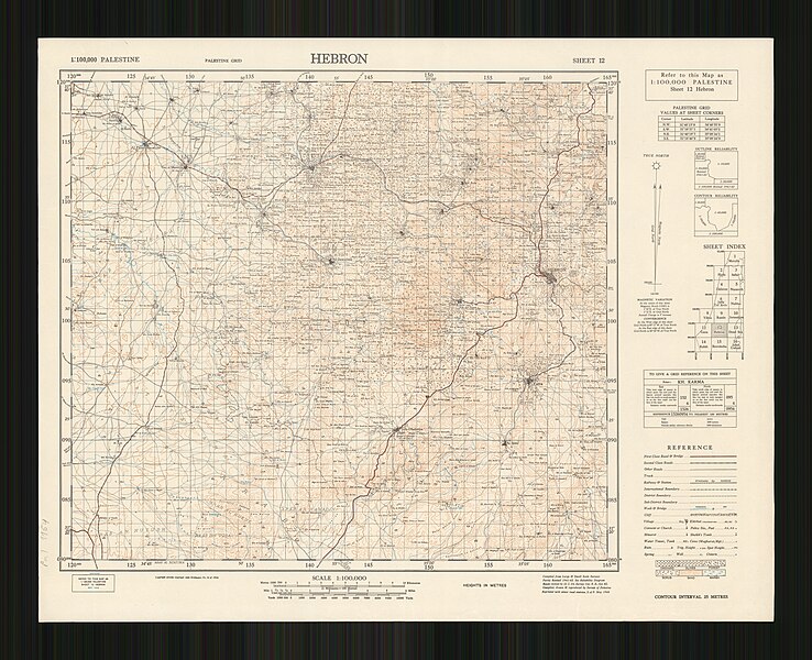
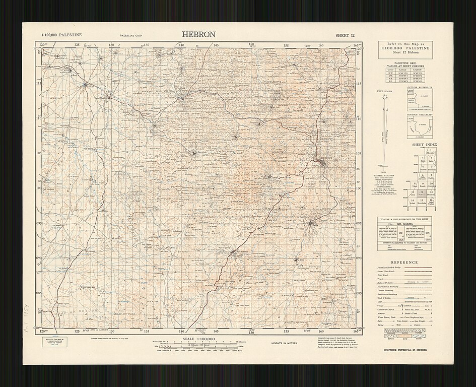
[edit]| Survey of Palestine: Hebron
( |
||||||||||||||||||||||||
|---|---|---|---|---|---|---|---|---|---|---|---|---|---|---|---|---|---|---|---|---|---|---|---|---|
| Artist |
|
|||||||||||||||||||||||
| Title |
Hebron |
|||||||||||||||||||||||
| Publisher |
Survey of Palestine |
|||||||||||||||||||||||
| Description |
Hebron. Compiled, drawn & reproduced by Survey of Palestine. |
|||||||||||||||||||||||
| Language | English | |||||||||||||||||||||||
| Publication date | 1946 | |||||||||||||||||||||||
| Medium | 1 sheet : color ; | |||||||||||||||||||||||
| Dimensions | height: 49 cm (19.2 in); width: 61 cm (24 in) | |||||||||||||||||||||||
| Collection |
|
|||||||||||||||||||||||
| Current location |
|
|||||||||||||||||||||||
| Place of publication | Jaffa | |||||||||||||||||||||||
| search Merhav catalog | Jaffa | |||||||||||||||||||||||
| Notes |
English: Palestine. 1:100,000. 1942-1947 ; 12 | |||||||||||||||||||||||
| scale | 1:100,000 cm | |||||||||||||||||||||||
| IE PID | IE60505833 | |||||||||||||||||||||||
| Rosetta filename | FL60505835 | |||||||||||||||||||||||
| NNL item ID (P3959) | 990038095430205171 | |||||||||||||||||||||||
| search Merhav catalog | English, Survey of Palestine | |||||||||||||||||||||||
| search Merhav catalog | Survey of Palestine | |||||||||||||||||||||||
| Source/Photographer |
|
|||||||||||||||||||||||
| Other versions | ||||||||||||||||||||||||
| Jpg / Tif version |
|
|||||||||||||||||||||||

.jpg)

.jpg&action=edit§ion=1)
Licensing
[edit].jpg&action=edit§ion=2)
This work created by the United Kingdom Government is in the public domain.
This is because it is one of the following:
HMSO has declared that the expiry of Crown Copyrights applies worldwide (ref: HMSO Email Reply)
|
 |
File history
Click on a date/time to view the file as it appeared at that time.
| Date/Time | Thumbnail | Dimensions | User | Comment | |
|---|---|---|---|---|---|
| current | 15:05, 9 August 2023 | | 16,094 × 13,078 (234.87 MB) | Geagea (talk | contribs) | pattypan 22.03 |
You cannot overwrite this file.
File usage on Commons
The following 3 pages use this file:
.jpg&redirect=no)
.jpg&oldid=792157923)