File:Superstrada Rieti-Torano - ipotesi ultimo lotto.svg
Jump to navigation
Jump to search

Size of this PNG preview of this SVG file: 800 × 514 pixels. Other resolutions: 320 × 206 pixels | 640 × 411 pixels | 1,024 × 658 pixels | 1,280 × 823 pixels | 2,560 × 1,646 pixels | 1,551 × 997 pixels.
Original file (SVG file, nominally 1,551 × 997 pixels, file size: 994 KB)
Captions
Captions
Add a one-line explanation of what this file represents
Summary
[edit]
| Description |
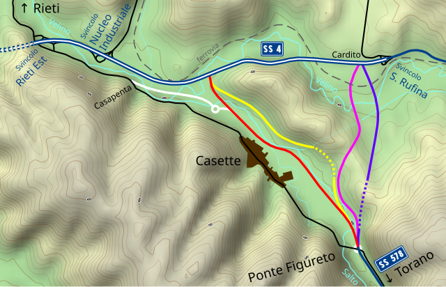
Italiano: Le diverse ipotesi di tracciato per l'ultimo lotto (Rieti-Ponte Figureto) necessario per il completamento della superstrada Rieti-Torano (statale 578 Salto Cicolana):
Tracciato T1 (proposto dalla provincia)
Tracciato T2 (proposto dalla provincia)
Tracciato T3 (proposto dalla provincia)
Tracciato T3C (proposto dal comune di Cittaducale)
Tracciato T4 "delle rotatorie" (proposto dalla provincia)
Vecchio percorso della statale 578 e altra viabilità ordinaria
Superstrade a doppia carreggiata
Superstrade a carreggiata singola
Gallerie
Ferrovia
Fiumi
|
| Date | |
| Source |
Own work. Road icons from File:Strada Statale 4 Italia.svg and File:Strada Statale 578 Italia.svg. |
| Author | Alessandro Antonelli |
Licensing
[edit]
I, the copyright holder of this work, hereby publish it under the following license:
This file is licensed under the Creative Commons Attribution 3.0 Unported license.
- You are free:
- to share – to copy, distribute and transmit the work
- to remix – to adapt the work
- Under the following conditions:
- attribution – You must give appropriate credit, provide a link to the license, and indicate if changes were made. You may do so in any reasonable manner, but not in any way that suggests the licensor endorses you or your use.
| This work contains information from OpenStreetMap, which is made available under the Open Database License (ODbL).
The ODbL does not require any particular license for maps produced from ODbL data. Prior to 1 August 2020, map tiles produced by the OpenStreetMap Foundation were licensed under the CC-BY-SA-2.0 license. Maps produced by other people may be subject to other licences. |
File history
Click on a date/time to view the file as it appeared at that time.
| Date/Time | Thumbnail | Dimensions | User | Comment | |
|---|---|---|---|---|---|
| current | 01:01, 5 April 2019 | | 1,551 × 997 (994 KB) | Una giornata uggiosa '94 (talk | contribs) | User created page with UploadWizard |
You cannot overwrite this file.
File usage on Commons
The following page uses this file:
File usage on other wikis
The following other wikis use this file:
- Usage on it.wikipedia.org