File:Superpower map 1945.png
Jump to navigation
Jump to search

Size of this preview: 800 × 351 pixels. Other resolutions: 320 × 140 pixels | 640 × 281 pixels | 1,425 × 625 pixels.
Original file (1,425 × 625 pixels, file size: 23 KB, MIME type: image/png)
Captions
Captions
Add a one-line explanation of what this file represents
Legend
[edit]

|
This map image could be re-created using vector graphics as an SVG file. This has several advantages; see Commons:Media for cleanup for more information. If an SVG form of this image is available, please upload it and afterwards replace this template with
{{vector version available|new image name}}.
It is recommended to name the SVG file “Superpower map 1945.svg”—then the template Vector version available (or Vva) does not need the new image name parameter. |
English:
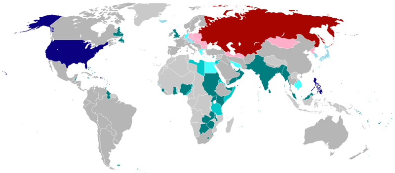
English (en): Map of the world in 1945 with dependencies in lighter shading and respective superpowers at the time.
British Trust Territories
British Postwar Occupations
US postwar Occupations
Soviet postwar Occupations
বাংলা :
বাংলা (bn): ১৯৪৫ সালের মানচিত্রে পরাশক্তি ও তাদের উপর নির্ভর রাষ্ট্রসমূহ
ব্রিটিশ সাম্রাজ্য
ব্রিটিশদের বিশ্বস্ত অঞ্চলসমূহ
যুক্তরাষ্ট্র
যুক্তরাষ্ট্র বিশ্বস্ত অঞ্চলসমুহ
সোভিয়েত ইউনিয়ন
| This work has been released into the public domain by its author, projectname at English Wikipedia. This applies worldwide. In some countries this may not be legally possible; if so: projectname grants anyone the right to use this work for any purpose, without any conditions, unless such conditions are required by law. |
.
File history
Click on a date/time to view the file as it appeared at that time.
| Date/Time | Thumbnail | Dimensions | User | Comment | |
|---|---|---|---|---|---|
| current | 01:25, 19 October 2020 | | 1,425 × 625 (23 KB) | RickoTroanman22 (talk | contribs) | Fixed Hong Kong, also Tibet did not claim Inner Tibet. |
| 22:22, 6 January 2019 |  | 1,425 × 625 (39 KB) | BMacZero (talk | contribs) | colored most Aleutian Islands as United States | |
| 14:41, 2 July 2017 |  | 1,425 × 625 (39 KB) | Fireinacrowdedtheatre (talk | contribs) | Changed New Zealand to grey; the majority-white Dominions were not under British control by 1945 (except Newfoundland). Also added Soviet occupation of central Europe and Mongolia, British occupation of Greece, American occupation of Iceland, and the B... | |
| 23:11, 7 October 2014 |  | 1,425 × 625 (43 KB) | ZaidRock11 (talk | contribs) | Added post-World War II occupations in 1945 (Germany, Austria, Korea, Japan, Kwantung, Indochina); New Zealand did get full independence until 1947. | |
| 07:41, 9 June 2013 |  | 1,425 × 625 (36 KB) | Elmor (talk | contribs) | Germany occupation zones+Saar | |
| 00:11, 10 February 2012 |  | 1,425 × 625 (51 KB) | Quintucket (talk | contribs) | Reverted to version as of 17:28, 20 August 2011 I missed the addition of Trust territories | |
| 07:14, 28 January 2012 |  | 1,357 × 628 (52 KB) | Quintucket (talk | contribs) | Reverted to version as of 21:44, 27 June 2007 Like User:Swarm said, India and the Philippines were still colonies at the time. Belarus and Ukraine were both UN members, which doesn't mean we should show them as non-USSR | |
| 08:12, 1 December 2011 |  | 1,425 × 625 (57 KB) | 23prootie~commonswiki (talk | contribs) | The Philippines and India are United Nations members in 1945 with guaranteed independence. They don't count. | |
| 17:28, 20 August 2011 |  | 1,425 × 625 (51 KB) | Swarm (talk | contribs) | re-add Philippines, which did not gain independence until 1946. It was commonwealth status they gained in 1934, not independence. | |
| 00:29, 27 October 2010 |  | 1,425 × 625 (51 KB) | Vadac (talk | contribs) | Clearer version, the Philippines became independent in 1934, added Mandates and Trust Territories. |
You cannot overwrite this file.
File usage on Commons
The following page uses this file:
File usage on other wikis
The following other wikis use this file:
- Usage on ar.wikipedia.org
- Usage on ast.wikipedia.org
- Usage on az.wikipedia.org
- Usage on be.wikipedia.org
- Usage on el.wikipedia.org
- Usage on en.wikipedia.org
- Usage on es.wikipedia.org
- Usage on fa.wikipedia.org
- Usage on fr.wikipedia.org
- Usage on he.wikipedia.org
- Usage on hy.wikipedia.org
- Usage on id.wikipedia.org
- Usage on ja.wikipedia.org
- Usage on ko.wikipedia.org
- Usage on lt.wikipedia.org
- Usage on no.wikipedia.org
- Usage on pl.wikipedia.org
- Usage on pt.wikipedia.org
- Usage on ru.wikipedia.org
- Usage on sco.wikipedia.org
- Usage on ta.wikipedia.org
- Usage on th.wikipedia.org
- Usage on uz.wikipedia.org
- Usage on zh-yue.wikipedia.org
- Usage on zh.wikipedia.org