File:Super Typhoon Trami in the Western Pacific (NESDIS 2018-09-24).jpg
Jump to navigation
Jump to search

Size of this preview: 800 × 450 pixels. Other resolutions: 320 × 180 pixels | 640 × 360 pixels | 1,024 × 576 pixels | 1,280 × 720 pixels | 1,920 × 1,080 pixels.
Original file (1,920 × 1,080 pixels, file size: 560 KB, MIME type: image/jpeg)
Captions
Captions
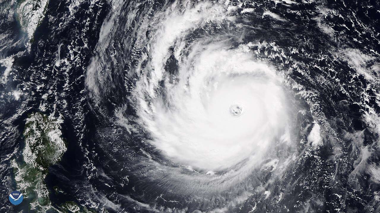
Less than ten days after Super Typhoon Mangkhut battered the Philippines and southern China, another powerful tropical cyclone is churning through the western Pacific Ocean.
Summary
[edit].jpg&action=edit§ion=1)
| Description |
English: Less than ten days after Super Typhoon Mangkhut battered the Philippines and southern China, another powerful tropical cyclone is churning through the western Pacific Ocean. Super Typhoon Trami, seen here from the NOAA-20 polar orbiting satellite at 12:23 a.m. EDT September 24, could threaten parts of Taiwan and Japan's Ryukyu Islands later this week. About eight hours after NOAA-20 captured this image of the storm, Trami's one-minute sustained winds had reached 150 mph the threshold at which the U.S. Joint Typhoon Warning Center considers a tropical cyclone to have achieved "super typhoon" status. Trami first developed as a tropical storm on September 21, but quickly strengthened as it moved across the warm waters of the Philippine Sea. Over a 24-hour period ending September 23, Trami had morphed from a tropical storm with 65 mph winds to a dangerous Category 4 tropical cyclone with winds of 130 mph. Forecasts show Trami's peak winds may reach Category 5 intensity (157 mph or greater) over the next 24 hours as the storm moves west-northwest into the warm waters of the East China Sea. This image was captured by the NOAA-20 satellite's VIIRS instrument , which scans the entire globe twice daily at a 750-meter resolution. The VIIRS sensor provides high-resolution visible and infrared imagery of Earth's atmosphere, land, and oceans, and helps atmospheric scientists monitor severe weather events such as tropical cyclones (which are commonly referred to as typhoons in the western Pacific and hurricanes in the eastern Pacific and Atlantic Ocean). |
| Date | 24 September 2018 (upload date) |
| Source | Super Typhoon Trami in the Western Pacific |
| Author | NOAA |
Licensing
[edit].jpg&action=edit§ion=2)
This image is in the public domain because it contains materials that originally came from the U.S. National Oceanic and Atmospheric Administration, taken or made as part of an employee's official duties.
|
File history
Click on a date/time to view the file as it appeared at that time.
| Date/Time | Thumbnail | Dimensions | User | Comment | |
|---|---|---|---|---|---|
| current | 23:31, 31 May 2024 | | 1,920 × 1,080 (560 KB) | OptimusPrimeBot (talk | contribs) | #Spacemedia - Upload of https://nesdis-prod.s3.amazonaws.com/migrated/20180924-TYPTrami01.jpg via Commons:Spacemedia |
You cannot overwrite this file.
File usage on Commons
There are no pages that use this file.
.jpg&oldid=880565409)