File:Super Outbreak map midwest.gif
Jump to navigation
Jump to search
No higher resolution available.
Super_Outbreak_map_midwest.gif (800 × 600 pixels, file size: 373 KB, MIME type: image/gif)
Captions
Captions
Add a one-line explanation of what this file represents
Summary
[edit]
| Description |
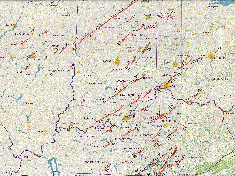
English: Map of the tornado tracks in Illinois, Indiana, Ohio and Kentucky during the Super Outbreak of April 3-4, 1974
Français : carte des trajectoire des tornades en Illinois, Indiana, Ohio et Kentucky durant le Super Outbreak des 3 et 4 avril 1974 |
| Date | |
| Source | http://www.publicaffairs.noaa.gov/storms/images/mapillinois.gif |
| Author | National Oceanic and Atmospheric Admistration public Affairs |
Licensing
[edit]
This image is in the public domain because it contains materials that originally came from the U.S. National Oceanic and Atmospheric Administration, taken or made as part of an employee's official duties.
|
File history
Click on a date/time to view the file as it appeared at that time.
| Date/Time | Thumbnail | Dimensions | User | Comment | |
|---|---|---|---|---|---|
| current | 11:52, 30 June 2010 | | 800 × 600 (373 KB) | Pierre cb (talk | contribs) | {{Information |Description={{en|1=Map of the tornado tracks in Illinois, Indiana, Ohio and Kentucky during the Super Outbreak of April 3-4, 1974}} {{fr|1=carte des trajectoire des tornades en Illinois, Indiana, Ohio et Kentucky dura |
You cannot overwrite this file.
File usage on Commons
There are no pages that use this file.
File usage on other wikis
The following other wikis use this file:
- Usage on fr.wikipedia.org