File:Sunset at Mountain Nemrut.jpg

Original file (5,230 × 3,490 pixels, file size: 22.26 MB, MIME type: image/jpeg)
Captions
Captions
Summary
[edit]
| Description |
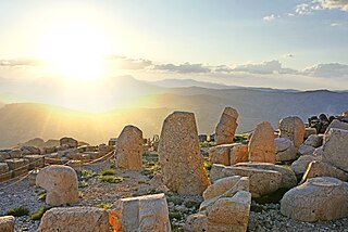
English: The mountain lies 40 km (25 mi) north of Kahta, near Adıyaman. In 62 BCE, King Antiochus I Theos of Commagene built on the mountain top a tomb-sanctuary flanked by huge statues 8–9-metre high (26–30 ft) of himself, two lions, two eagles and various Greek and Iranian gods, such as Heracles-Artagnes-Ares, Zeus-Oromasdes, and Apollo-Mithras-Helios-Hermes. These statues were once seated, with names of each god inscribed on them. The heads of the statues at some stage have been removed from their bodies, and they are now scattered throughout the site.
The pattern of damage to the heads (notably to noses) suggests that they were deliberately damaged as a result of iconoclasm. The statues have not been restored to their original positions. The site also preserves stone slabs with bas-relief figures that are thought to have formed a large frieze. These slabs display the ancestors of Antiochus, who included Greeks and Persians. The same statues and ancestors found throughout the site can also be found on the tumulus at the site, which is 49-metre tall (161 ft) and 152 m (499 ft) in diameter. It is possible that the tumulus of loose rock was built to protect a tomb from robbers, since any excavation would quickly fill in.The statues appear to have Greek-style facial features, but Persian clothing and hair-styling. The Lion with the Stars The western terrace contains a large slab with a lion, showing an arrangement of stars and the planets Jupiter, Mercury and Mars. The composition was taken to be a chart of the sky on 7 July 62 BCE.[4] This may be an indication of when construction began on this monument. The eastern portion is well preserved, being composed of several layers of rock, and a path following the base of the mountain is evidence of a walled passageway linking the eastern and western terraces. Possible uses for this site are thought to have included religious ceremonies, owing to the astronomical and religious nature of the monument. The arrangement of such statues is known by the term hierothesion. Similar arrangements have been found at Arsameia on Nymphaios at the hierothesion of Mithridates I Callinicus, the father of Antiochus. When the Seleucid Empire was defeated by the Romans in 190 BC at the Battle of Magnesia it began to fall apart and new kingdoms were established on its territory by local authorities. Commagene, one of the Seleucid successor states, occupied a land between the Taurus mountains and the Euphrates. The state of Commagene had a wide range of cultures which left its leader from 62 BC – 38 BC Antiochus I Theos to carry on a peculiar dynastic religious program, which included not only Greek and Iranian deities but Antiochus and his family as well. This religious program was very possibly an attempt by Antiochus to unify his multiethnic kingdom and secure his dynasty's authority. Antiochus supported the cult as a propagator of happiness and salvation.[6] Many of the ruins on Mount Nemrud are monuments of the imperial cult of Commagene. The most important area to the cult was the tomb of Antiochus I, which was decorated with colossal statues made of limestone. Although the imperial cult did not last long after Antiochus, several of his successors had their own tombs built on Mount Nemrud.[7] For around half of the year, Mount Nemrud is covered in snow, the effect of which increases weathering, which has in part caused the statues to fall in ruin. The site was excavated in 1881 by Karl Sester, a German engineer assessing transport routes for the Ottomans. After her first visit in 1947, Theresa Goell dedicated her life to the site, starting campaigns in 1954. Subsequent excavations have failed to reveal the tomb of Antiochus. This is nevertheless still believed to be the site of his burial. The statues, all of them "beheaded", have not been restored to their original condition.In 1987, Mount Nemrut was made a World Heritage Site by UNESCO. Tourists typically visit Nemrut during April through October. The nearby town of Adıyaman is a popular place for car and bus trips to the site, and one can also travel from there by helicopter. There are also overnight tours running out of Malatya or Kahta. Türkçe: Nemrut Dağı Millî Parkı, Adıyaman ili; Kâhta ilçesinde bulunan ve içinde Kommagene Krallığı'nın bir antik kentini barındıran millî park ve ören yeri. Adıyaman il merkezinde Kâhta'ya bağlantı sağlayan karayolu ile ulaşım sağlanmakta olup, Millî Park Adıyaman il sınırları içerisindedir. Adıyaman hava alanından ulaşım oldukça rahat ve kolaydır. Adıyaman ve Kahta ilçesinden Nemrut dağına ve diğer tarihi yerlere servisler vardır.
Nemrut Dağı ve Kommagene Kralı Antiochos'a ait Tümülüs ve kutsal alanlar, Millî Park'ın ana özelliğini teşkil etmektedir. Antiochos'un tümülüsü ve dev heykelleri, Arsameia (Eskikale),Yenikale, Karakuş Tepe ve Cendere Köprüsü Millî Park içerisinde kalan kültürel değerlerdir. Eski çağlarda Komagene olarak anılan bu bölgede, I.Mithradates tarafından bağımsız bir krallık kurulmuş, krallık onun oğlu I. Antiochos (M.Ö. 62-32)un egemen olduğu yıllarda önem kazanmıştır. MS.72 yılında da Roma'ya karşı yapılan ve kaybedilen savaş ile krallığın bağımsızlığı sona ermiştir. Nemrut Dağı doruğundaki kalıntıları yerleşme yeri olmayıp Antiochos'un Tümülüsü ve kutsal alanlardır. Tümülüs, 2150 metre yüksekliğinde, Fırat Nehri geçitlerine ve ovalarına hakim tepe üzerinde bulunmaktadır. Kralın kemiklerinin ya da küllerinin anakayaya oyulmuş odaya konulduğu ve 50 metre yüksekliğinde ve 150 metre çapındaki tümülüs ile örtüldüğü düşünülmektedir. Girişi kuzeyden olup doğuda ve batıda dini törenlerin yapıldığı teras şeklindeki avlular yer almaktadır. Her iki terasta da aslan ve kartal heykelleri arasında yüksekliği 7 metreye ulaşan oturur vaziyette dev heykeller sıralanır, bunlar yazıtları ve kabartmaları olan ortostad (dik olarak konulan büyük taş bloklar)'la çevrilmiştir. Eski Kahta Köyü yakınında Kommagene'nın başkenti Arsameia yer alır. Burada, Mithridates'in kutsal alanı bulunmaktadır. Kahta Çayı'nın bir kolu olan Cendere Çayı'nın daraldığı yerde iki ana kaya üzerinde tek kemerli olarak yapılan Cendere Köprüsü yer almaktadır. Köprü sütunları üzerindeki kitabeye göre Kommagene şehirleri tarafından Roma İmparatoru Septimus Severus (MS 193-211)ile karısı ve oğulları onuruna yaptırılmıştır. Arsameia'nın 10 km güneybatısında 21 metre yüksekliğinde krallık kadınlarının gömüldüğü Karakuş Tepe Tümülüsü bulunmaktadır. |
| Date | |
| Source | Own work |
| Author | Emrahuygun |
Licensing
[edit]
- You are free:
- to share – to copy, distribute and transmit the work
- to remix – to adapt the work
- Under the following conditions:
- attribution – You must give appropriate credit, provide a link to the license, and indicate if changes were made. You may do so in any reasonable manner, but not in any way that suggests the licensor endorses you or your use.
- share alike – If you remix, transform, or build upon the material, you must distribute your contributions under the same or compatible license as the original.
File history
Click on a date/time to view the file as it appeared at that time.
| Date/Time | Thumbnail | Dimensions | User | Comment | |
|---|---|---|---|---|---|
| current | 14:07, 24 June 2020 | | 5,230 × 3,490 (22.26 MB) | Emrahuygun (talk | contribs) | Uploaded own work with UploadWizard |
You cannot overwrite this file.
File usage on Commons
The following page uses this file: