File:Sungkeman muslim jawa.jpg
Jump to navigation
Jump to search
Size of this preview: 800 × 544 pixels. Other resolutions: 320 × 218 pixels | 640 × 435 pixels | 1,024 × 696 pixels | 1,280 × 870 pixels | 2,560 × 1,741 pixels | 3,415 × 2,322 pixels.
Original file (3,415 × 2,322 pixels, file size: 2.9 MB, MIME type: image/jpeg)
Captions
Captions
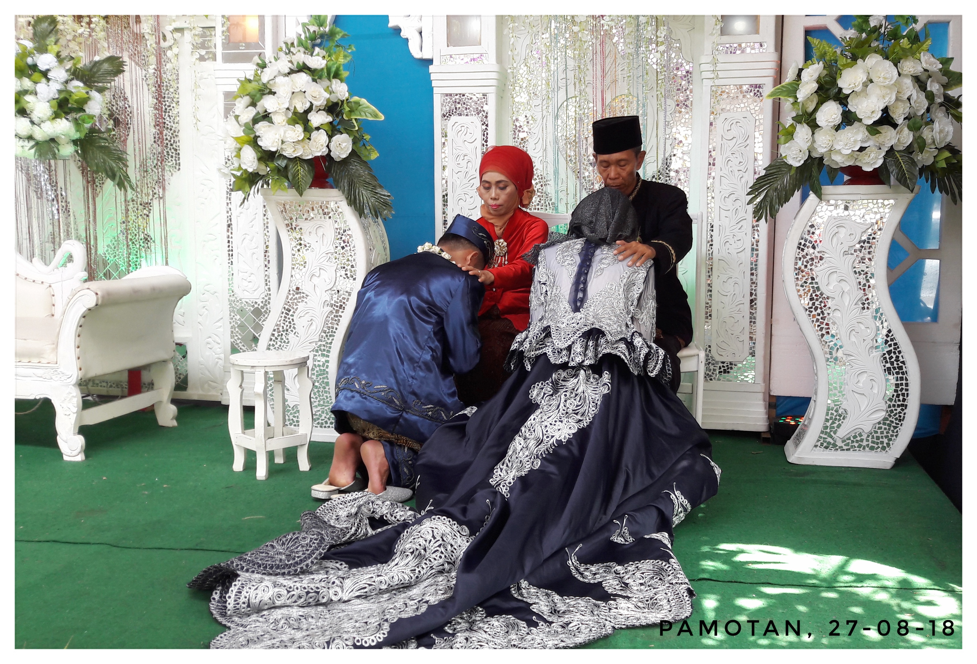
Sungkeman as a statement of apology and gratitude from the bride to parents in the wedding ceremony
Summary
[edit]
| Description |
Bahasa Indonesia: Sungkeman merupakan salah satu momen mengharukan yang terjadi dalam upacara pernikahan di Indonesia, terutama di wilayah Jawa. Kegiatan ini biasanya dilakukan tepat setelah akad nikah. Kegiatan ini dilakukan oleh pengantin dengan cara berlutut atau jongkok di hadapan kedua orang tua. Saat melakukan sungkeman, pengantin akan mengungkapkan rasa terima kasih atas segala kasih sayang dan bimbingan orang tuanya dari sejak bayi hingga dewasa, selain itu pengantin juga memohon maaf atas segala kesalahannya di masa lalu. Selanjutnya, orang tua akan memberikan restu dan nasihat kepada pengantin untuk memulai kehidupan rumah tangga yang baru.
Sungkeman menjadi kegiatan paling emosional bagi orang tua karena harus melepas sang anak untuk hidup bersama pasangan pilihannya. Tidak jarang saat acara sungkeman, para tamu undangan yang menyaksikan juga akan merasa terharu.
English: Sungkeman is one of the touching moments that took place in a wedding ceremony in Indonesia, especially in the Java region. This activity is usually carried out right after the marriage blessing. This activity is carried out by the bride and the groom by kneeling or squatting in front of both parents. When doing sungkeman, the bride and the groom will express their gratitude for all the love and guidance of their parents from infancy to adulthood, besides that they also apologizes for all their mistakes in the past. Next, parents will give their blessings and advice to them to start a new household life.
Sungkeman is the most emotional activity for parents because they have to let go of the children to live with their chosen partner. Not infrequently during the Sungkeman event, invited guests who witnessed will also feel touched.
|
||
| Date | |||
| Source | Own work | ||
| Author | Yuni emb |
| Camera location | | View this and other nearby images on: OpenStreetMap |
|---|
Licensing
[edit]
I, the copyright holder of this work, hereby publish it under the following license:
This file is licensed under the Creative Commons Attribution-Share Alike 4.0 International license.
- You are free:
- to share – to copy, distribute and transmit the work
- to remix – to adapt the work
- Under the following conditions:
- attribution – You must give appropriate credit, provide a link to the license, and indicate if changes were made. You may do so in any reasonable manner, but not in any way that suggests the licensor endorses you or your use.
- share alike – If you remix, transform, or build upon the material, you must distribute your contributions under the same or compatible license as the original.
This image was uploaded as part of Wiki Loves Love 2019 photographic contest.
|
File history
Click on a date/time to view the file as it appeared at that time.
| Date/Time | Thumbnail | Dimensions | User | Comment | |
|---|---|---|---|---|---|
| current | 01:44, 27 February 2019 | | 3,415 × 2,322 (2.9 MB) | Yuni emb (talk | contribs) | User created page with UploadWizard |
You cannot overwrite this file.
File usage on Commons
The following page uses this file:
File usage on other wikis
The following other wikis use this file:
- Usage on ar.wikipedia.org
- Usage on id.wikipedia.org
- Usage on ta.wikipedia.org