File:Sunda Kingdom id.svg
Jump to navigation
Jump to search

Size of this PNG preview of this SVG file: 598 × 304 pixels. Other resolutions: 320 × 163 pixels | 640 × 325 pixels | 1,024 × 521 pixels | 1,280 × 651 pixels | 2,560 × 1,301 pixels.
Original file (SVG file, nominally 598 × 304 pixels, file size: 225 KB)
Captions
Captions
Add a one-line explanation of what this file represents
Summary
[edit]| Description |
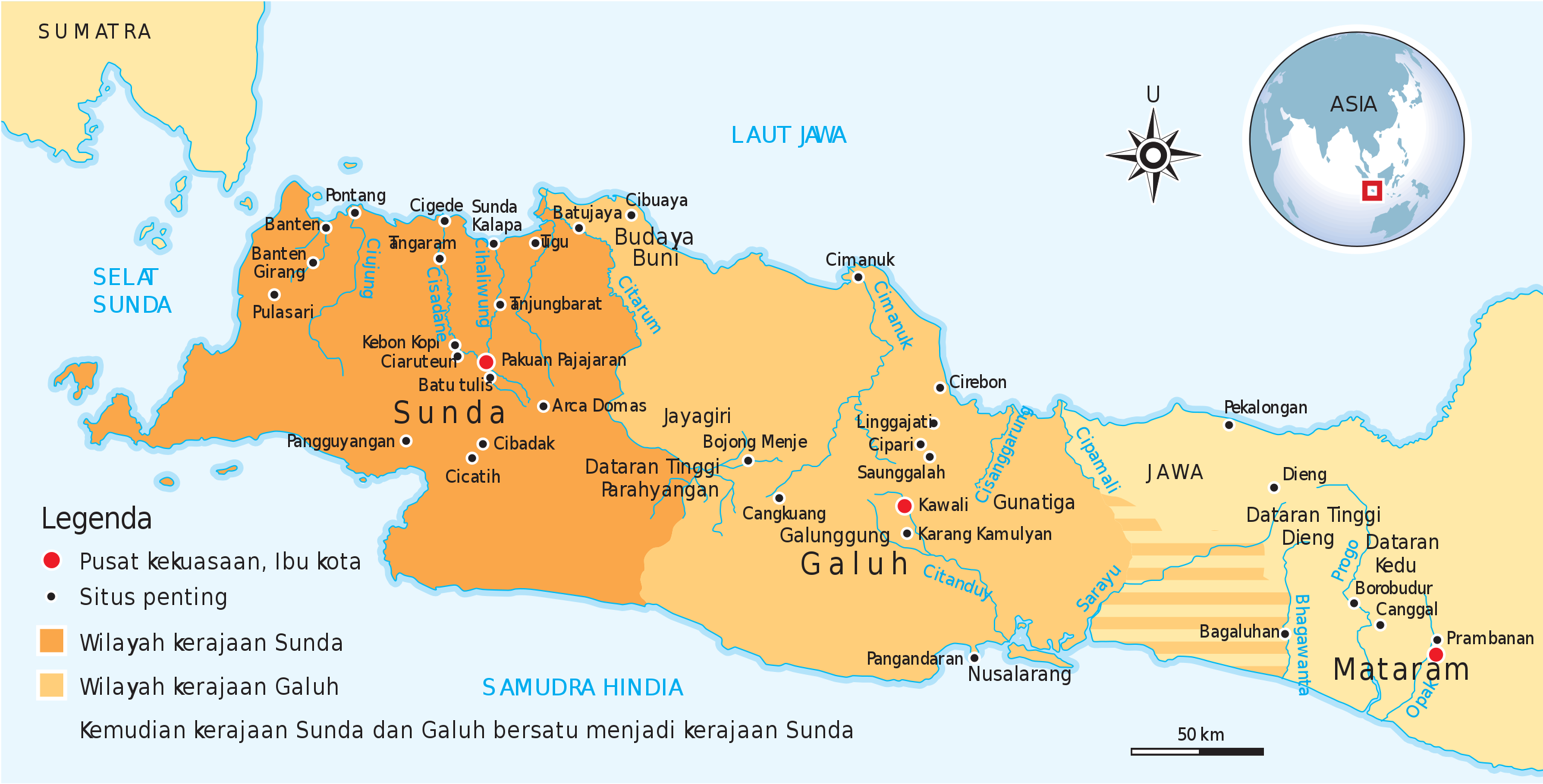
Bahasa Indonesia: Wilayah historis kerajaan Sunda, Galuh, hingga Kerajaan Sunda Pajajaran. |
| Date | |
| Source | Own work by uploader, see #References for references used creating the map. |
| Author | Gunawan Kartapranata |
| Other versions |
[]
|


|
This SVG file contains embedded text that can be translated into your language, using any capable SVG editor, text editor or the SVG Translate tool. For more information see: About translating SVG files. |
Licensing
[edit]
I, the copyright holder of this work, hereby publish it under the following licenses:
This file is licensed under the Creative Commons Attribution-Share Alike 3.0 Unported license.
- You are free:
- to share – to copy, distribute and transmit the work
- to remix – to adapt the work
- Under the following conditions:
- attribution – You must give appropriate credit, provide a link to the license, and indicate if changes were made. You may do so in any reasonable manner, but not in any way that suggests the licensor endorses you or your use.
- share alike – If you remix, transform, or build upon the material, you must distribute your contributions under the same or compatible license as the original.

|
Permission is granted to copy, distribute and/or modify this document under the terms of the GNU Free Documentation License, Version 1.2 or any later version published by the Free Software Foundation; with no Invariant Sections, no Front-Cover Texts, and no Back-Cover Texts. A copy of the license is included in the section entitled GNU Free Documentation License. |
You may select the license of your choice.
References
[edit]
Sumber yang digunakan untuk membuat peta ini:
- Munoz, Paul Michel (2006) Early Kingdoms of the Indonesian Archipelago and the Malay Peninsula, Singapore: Editions Didier Millet, pp. 203, 212 ISBN: 9814155675.
File history
Click on a date/time to view the file as it appeared at that time.
| Date/Time | Thumbnail | Dimensions | User | Comment | |
|---|---|---|---|---|---|
| current | 11:09, 8 February 2012 | | 598 × 304 (225 KB) | Gunkarta (talk | contribs) | add Bojong Menje and Karang Kamulyan site |
| 14:04, 6 November 2009 |  | 604 × 306 (223 KB) | Gunkarta (talk | contribs) | Mengidentifikasi dua entitas yang berbeda antara kerajaan Sunda dan Galuh, selain itu menghilangkan Tarumanagara dan Kalingga (Holing) karena berbeda era. | |
| 17:57, 5 November 2009 |  | 604 × 306 (206 KB) | Gunkarta (talk | contribs) | {{Information |Description={{en|1=Wilayah historis kerajaan Sunda, sejak zaman Tarumanagara, Galuh, hingga Kerajaan Sunda Pajajaran.}} |Source={{own}} |Author=Gunkarta Gunawan Kartapranata |Date=2009-11-06 |Permission= |other_versions= } |
You cannot overwrite this file.
File usage on Commons
The following 2 pages use this file:
File usage on other wikis
The following other wikis use this file:
- Usage on id.wikipedia.org
- Usage on jv.wikipedia.org
- Usage on ms.wikipedia.org