File:Sun and heat over Ireland and the United Kingdom (MODIS 2021-07-23).jpg

Original file (5,836 × 4,384 pixels, file size: 2.91 MB, MIME type: image/jpeg)
Captions
Captions
Summary
[edit].jpg&action=edit§ion=1)
| Description |
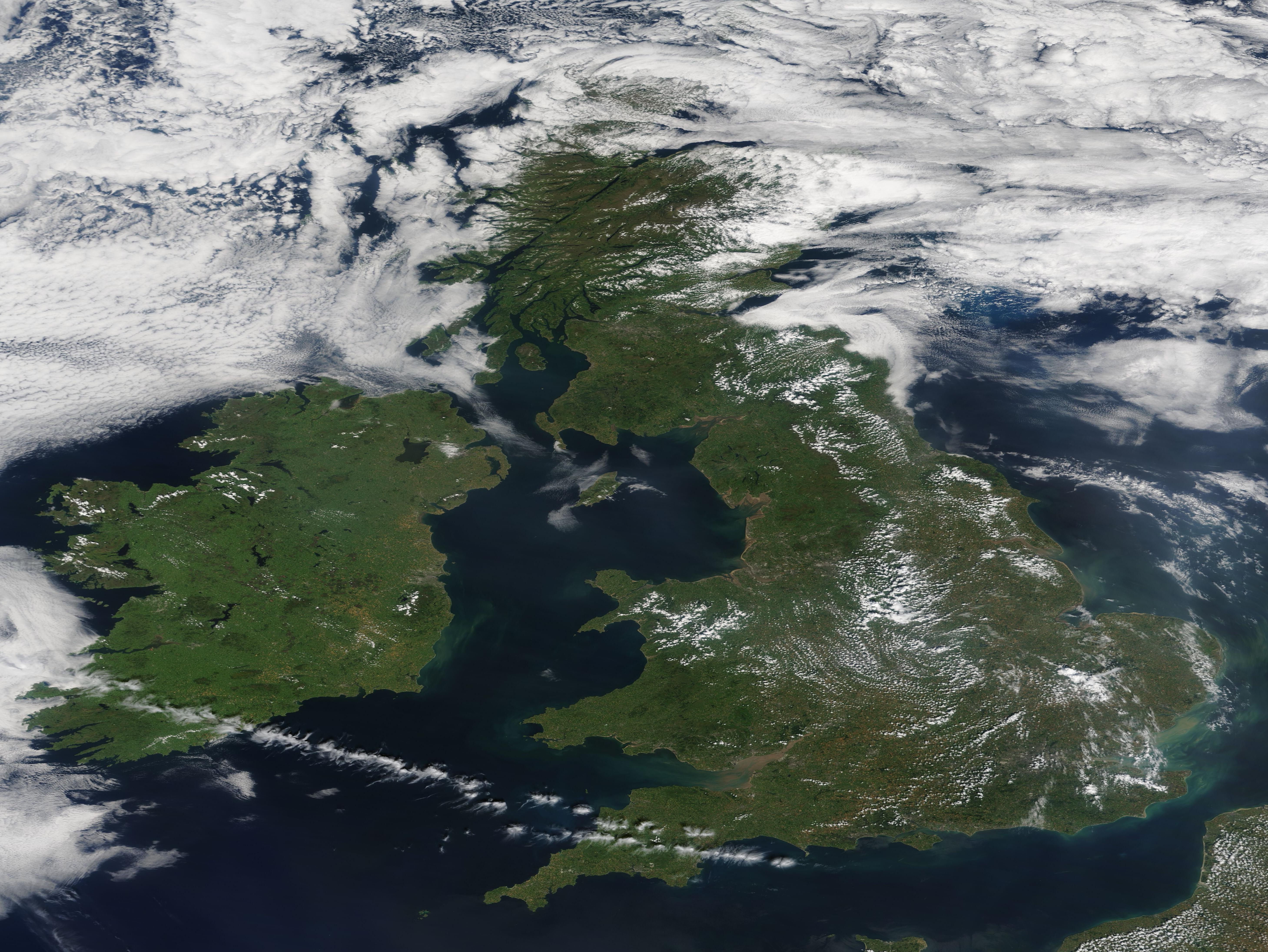
English: Ireland and the United Kingdom sweltered under a heatwave on July 20, 2021. For the first time ever, Britain’s Met Office issued an extreme weather warning as temperatures were expected to reach 33˚C (91.4 F) by the end of the week. The Irish National Meteorological Service, Met Éireann, also issued warnings for high temperatures on that same day. Cavan, Monaghan, south Leitrim, Roscommon, Longford, and Westmeath were under a Status Orange and most of the rest of the country was under a Status Yellow. Status Orange is the second-highest warning level, with Status Red higher and Status Yellow lower.
The Met Office reported that the highest temperature of the year on the island of Ireland was reached on July 21, with the reading of 31.3˚C (88.4˚F) at Castlederg, County Tyrone. Ireland was not far behind, with highs of 30.7˚C (87.3˚F) in County Roscommon, according to Met Éireann. London’s Heathrow Airport carried the high-temperature torch for the United Kingdom, spiking to 32.2˚C (90˚F) on July 20. While these temperatures are not as stunning, in hard numbers, as other heatwaves this summer, such as the 121˚F (49.4˚C) reported in Lytton, Canada in late June of this year, they are indeed stifling for these island nations that typically have more mild summer weather. For example, according to Weather Underground, the average high temperature on July 20 for London Heathrow Airport is 23.3˚C (74˚F), meaning that the heatwave high was 8.9˚C (16˚F) higher than average. Ireland’s average temperatures tend to be even cooler. The Ireland West Airport Knock Station, which is the closest weather station to Roscommon, reports an average high temperature of 18.3˚C (65˚F) on July 21—so that day’s high was 12.4˚F (22.3˚F) higher than average. The Moderate Resolution Imaging Spectroradiometer (MODIS) on board NASA’s Terra satellite acquired a true-color image of Ireland and the United Kingdom on June 20, as they sizzle on a hot, humid day. Small streaks of cloud provide some meager shade across parts of England. Heavier cloud cover hangs over far Northern Ireland and the tip of Scotland. |
||
| Date | Taken on 20 July 2021 | ||
| Source |
Sun and heat over Ireland and the United Kingdom (direct link)
|
||
| Author | MODIS Land Rapid Response Team, NASA GSFC |
| This media is a product of the Terra mission Credit and attribution belongs to the mission team, if not already specified in the "author" row |
Licensing
[edit].jpg&action=edit§ion=2)
| This file is in the public domain in the United States because it was solely created by NASA. NASA copyright policy states that "NASA material is not protected by copyright unless noted". (See Template:PD-USGov, NASA copyright policy page or JPL Image Use Policy.) | ||
 |
Warnings:
|
File history
Click on a date/time to view the file as it appeared at that time.
| Date/Time | Thumbnail | Dimensions | User | Comment | |
|---|---|---|---|---|---|
| current | 17:37, 30 January 2024 | | 5,836 × 4,384 (2.91 MB) | OptimusPrimeBot (talk | contribs) | #Spacemedia - Upload of http://modis.gsfc.nasa.gov/gallery/images/image07232021_250m.jpg via Commons:Spacemedia |
You cannot overwrite this file.
File usage on Commons
There are no pages that use this file.
.jpg&oldid=909385247)