File:Summer Lane railway station (site), Yorkshire (geograph 6537528).jpg
Jump to navigation
Jump to search

Size of this preview: 800 × 600 pixels. Other resolutions: 320 × 240 pixels | 640 × 480 pixels | 1,024 × 768 pixels | 1,280 × 960 pixels | 1,600 × 1,200 pixels.
Original file (1,600 × 1,200 pixels, file size: 591 KB, MIME type: image/jpeg)
Captions
Captions
Add a one-line explanation of what this file represents
Summary
[edit],_Yorkshire_(geograph_6537528).jpg&action=edit§ion=1)
| Description |
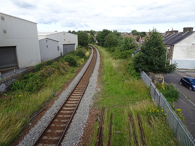
English: Summer Lane railway station (site), Yorkshire Opened in 1850 by the South Yorkshire Railway, later part of the Manchester Sheffield & Lincolnshire Railway, on the line from Penistone to Barnsley, this station closed to passengers in 1959 and was demolished. View north east towards Barnsley. When it was open, there were two tracks and two parallel curved platforms here. The main building would have been on the right of the image. |
| Date | |
| Source | From geograph.org.uk |
| Author | Nigel Thompson |
| Permission (Reusing this file) |
Creative Commons Attribution Share-alike license 2.0 |
| Attribution (required by the license) | Nigel Thompson / Summer Lane railway station (site), Yorkshire / |
| Camera location | | View this and other nearby images on: OpenStreetMap |
|---|
,_Yorkshire_(geograph_6537528).jpg¶ms=053.554056_N_-001.493696_E_globe:Earth_type:camera_source:geograph-osgb36(SE33640650)_heading:45.00&language=en)
| Object location | | View this and other nearby images on: OpenStreetMap |
|---|
,_Yorkshire_(geograph_6537528).jpg¶ms=053.554320_N_-001.493090_E_globe:Earth_class:object_type:object_source:geograph-osgb36(SE33680653)_heading:45.00&language=en)
Licensing
[edit],_Yorkshire_(geograph_6537528).jpg&action=edit§ion=2)

|
This image was taken from the Geograph project collection. See this photograph's page on the Geograph website for the photographer's contact details. The copyright on this image is owned by Nigel Thompson and is licensed for reuse under the Creative Commons Attribution-ShareAlike 2.0 license.
|
This file is licensed under the Creative Commons Attribution-Share Alike 2.0 Generic license.
Attribution: Nigel Thompson
- You are free:
- to share – to copy, distribute and transmit the work
- to remix – to adapt the work
- Under the following conditions:
- attribution – You must give appropriate credit, provide a link to the license, and indicate if changes were made. You may do so in any reasonable manner, but not in any way that suggests the licensor endorses you or your use.
- share alike – If you remix, transform, or build upon the material, you must distribute your contributions under the same or compatible license as the original.
File history
Click on a date/time to view the file as it appeared at that time.
| Date/Time | Thumbnail | Dimensions | User | Comment | |
|---|---|---|---|---|---|
| current | 10:34, 29 July 2020 | | 1,600 × 1,200 (591 KB) | Lamberhurst (talk | contribs) | Transferred from geograph.co.uk using [https://tools.wmflabs.org/geograph2commons/ geograph2commons] |
You cannot overwrite this file.
File usage on Commons
The following page uses this file:
File usage on other wikis
The following other wikis use this file:
- Usage on en.wikipedia.org
,_Yorkshire_(geograph_6537528).jpg&oldid=549132848)