File:Suelzchannelp.svg
Jump to navigation
Jump to search

Size of this PNG preview of this SVG file: 238 × 600 pixels. Other resolutions: 95 × 240 pixels | 190 × 480 pixels | 305 × 768 pixels | 406 × 1,024 pixels | 813 × 2,048 pixels | 512 × 1,290 pixels.
Original file (SVG file, nominally 512 × 1,290 pixels, file size: 491 KB)
Captions
Captions
Add a one-line explanation of what this file represents
Summary
[edit]
| Description |
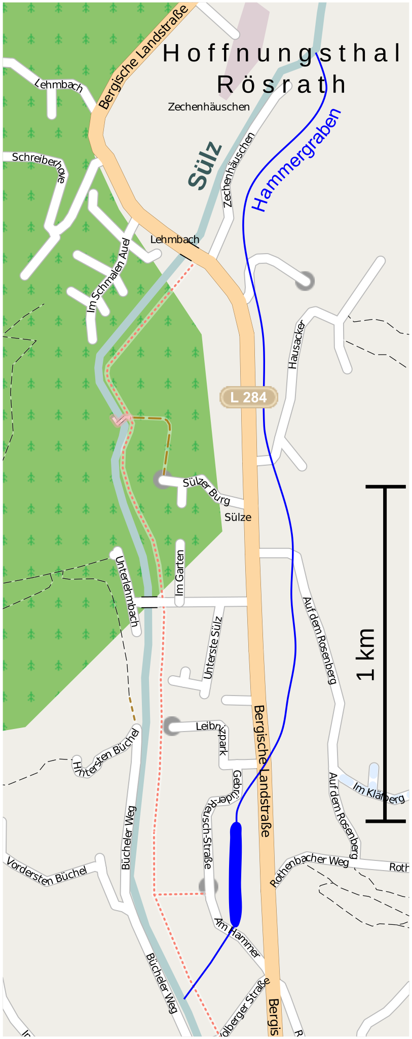
Deutsch: Ungefährer Verlauf des ehemaligen Sülzer Industriekanals Hammergraben in Hoffnungsthal (Rösrath). Der Kanal parallel zur Landstraße ist weitgehend erhalten, ebenso der Speichersee und Ablauf. Der Zulauf im Norden bestand mindestens bis 1970. |
||||||||||||
| Source |
Own work
|
||||||||||||
| Author | Zeitan |
| Object location | | View this and other nearby images on: OpenStreetMap |
|---|
Licensing
[edit]
I, the copyright holder of this work, hereby publish it under the following license:
This file is licensed under the Creative Commons Attribution-Share Alike 3.0 Unported license.
- You are free:
- to share – to copy, distribute and transmit the work
- to remix – to adapt the work
- Under the following conditions:
- attribution – You must give appropriate credit, provide a link to the license, and indicate if changes were made. You may do so in any reasonable manner, but not in any way that suggests the licensor endorses you or your use.
- share alike – If you remix, transform, or build upon the material, you must distribute your contributions under the same or compatible license as the original.
File history
Click on a date/time to view the file as it appeared at that time.
| Date/Time | Thumbnail | Dimensions | User | Comment | |
|---|---|---|---|---|---|
| current | 07:55, 26 May 2010 | 512 × 1,290 (491 KB) | S.fonsi (talk | contribs) | Schrift in Pfad | |
| 07:48, 26 May 2010 | 512 × 1,290 (473 KB) | S.fonsi (talk | contribs) | Dateigrösse reduziert | ||
| 20:18, 21 May 2010 | 395 × 995 (1.14 MB) | S.fonsi (talk | contribs) | Reverted to version as of 19:38, 21 May 2010 | ||
| 20:13, 21 May 2010 | 391 × 991 (469 KB) | S.fonsi (talk | contribs) | Dateigrösse verkleinert | ||
| 19:38, 21 May 2010 | 395 × 995 (1.14 MB) | S.fonsi (talk | contribs) | Auf wesentliche beschränkt | ||
| 16:26, 21 May 2010 | 390 × 990 (1.48 MB) | Zeitan~commonswiki (talk | contribs) | |||
| 16:58, 13 May 2010 | 390 × 990 (1.48 MB) | Zeitan~commonswiki (talk | contribs) | |||
| 22:21, 12 May 2010 | 390 × 990 (1.48 MB) | Uwe Dedering (talk | contribs) | removed link to external file | ||
| 19:46, 12 May 2010 | 390 × 990 (1.48 MB) | Zeitan~commonswiki (talk | contribs) | {{Information |Description={{de|1=Ungefährer Verlauf des ehemaligen Sülzer Industriekanals in Hoffnungsthal (Rösrath). Der Kanal parallel zur Bundesstraße ist weitgehend erhalten, ebenso der Speichersee und Ablauf. Der Zulauf im Norden bestand mindest | ||
| 19:32, 12 May 2010 | 390 × 990 (1.48 MB) | Zeitan~commonswiki (talk | contribs) | {{Information |Description={{de|1=Ungefährer Verlauf des ehemaligen Sülzer Industriekanals in Hoffnungsthal (Rösrath). Der Kanal parallel zur Bundesstraße ist weitgehend erhalten, ebenso der Speichersee und Ablauf. Der Zulauf im Norden bestand mindest |
You cannot overwrite this file.
File usage on Commons
There are no pages that use this file.
File usage on other wikis
The following other wikis use this file:
- Usage on de.wikipedia.org