File:Suchań (gmina) location map.png
Jump to navigation
Jump to search

Size of this preview: 800 × 442 pixels. Other resolutions: 320 × 177 pixels | 640 × 353 pixels | 944 × 521 pixels.
Original file (944 × 521 pixels, file size: 77 KB, MIME type: image/png)
Captions
Captions
Add a one-line explanation of what this file represents
| Description |
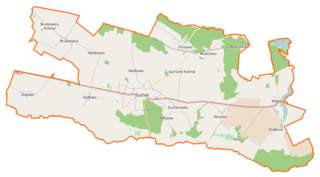
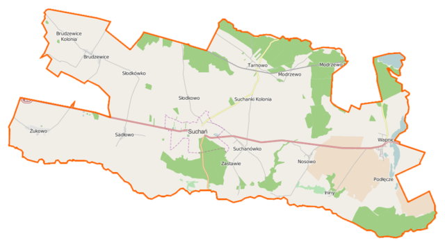
Polski: Mapa gminy Suchań, Polska
English: Map of Gmina Suchań, Poland |
|||||||||
| Date | ||||||||||
| Source | You may find a page on the OpenStreetMap wiki page for Suchań (gmina) | |||||||||
| Creator |
OpenStreetMap contributors OpenStreetMap contributors |
|||||||||
| Permission (Reusing this file) |
OpenStreetMap data is available under the Open Database License (details). Map tiles are licensed under the Creative Commons Attribution-ShareAlike 2.0 license (CC-BY-SA 2.0).
This file is licensed under the Creative Commons Attribution-Share Alike 2.0 Generic license.
|
|||||||||
| Geotemporal data | ||||||||||
| Bounding box |
|
|||||||||
| Georeferencing | If inappropriate please set warp_status = skip to hide. | |||||||||
File history
Click on a date/time to view the file as it appeared at that time.
| Date/Time | Thumbnail | Dimensions | User | Comment | |
|---|---|---|---|---|---|
| current | 13:38, 16 April 2015 | | 944 × 521 (77 KB) | VanWiel (talk | contribs) | {{OpenStreetMap | name = Suchań (gmina) | location = Suchań (gmina) | description = {{pl|Mapa gminy Suchań, Polska}} {{en|Map of Gmina Suchań, Poland}} | top = 53.3370 | bottom = 53.2301 | left... |
You cannot overwrite this file.
File usage on Commons
There are no pages that use this file.
File usage on other wikis
The following other wikis use this file:
- Usage on fr.wikipedia.org
- Usage on pl.wikipedia.org
- Suchań (gmina)
- Suchań
- Modrzewo
- Nosowo (powiat stargardzki)
- Słodkowo
- Słodkówko
- Suchanówko
- Brudzewice (województwo zachodniopomorskie)
- Sadłowo (województwo zachodniopomorskie)
- Tarnowo (powiat stargardzki)
- Wapnica (powiat stargardzki)
- Żukowo (powiat stargardzki)
- Suchanki
- Podłęcze (powiat stargardzki)
- Kolonia Brudzewice
- Zaolzie (Brudzewice)
- Ininy
- Zastawie (Suchanówko)
- Tarnowo Pomorskie
- Kolonia Modrzewo
- Parafia Matki Bożej Nieustającej Pomocy w Suchaniu
- Cmentarz żydowski w Suchaniu
- Kościół Matki Bożej Nieustającej Pomocy w Suchaniu
- Dęby szypułkowe w Suchaniu
- Moduł:Mapa/dane/Suchań (gmina)
- Moduł:Mapa/dane/Suchań
- Kościół św. Jana Kantego w Wapnicy
- Parafia św. Jana Kantego w Wapnicy
- Wapnica Południowa
- Jezioro Sierakowskie
- Usage on pl.wikibooks.org
_location_map.png&oldid=496894544)