File:Submarine-spring Vrulja-Bay Brela Biokovo Croatia.jpg
Jump to navigation
Jump to search

Size of this preview: 800 × 537 pixels. Other resolutions: 320 × 215 pixels | 640 × 430 pixels | 1,024 × 687 pixels | 1,280 × 859 pixels | 2,896 × 1,944 pixels.
Original file (2,896 × 1,944 pixels, file size: 3.53 MB, MIME type: image/jpeg)
Captions
Captions
Add a one-line explanation of what this file represents
Summary
[edit]
| Description |
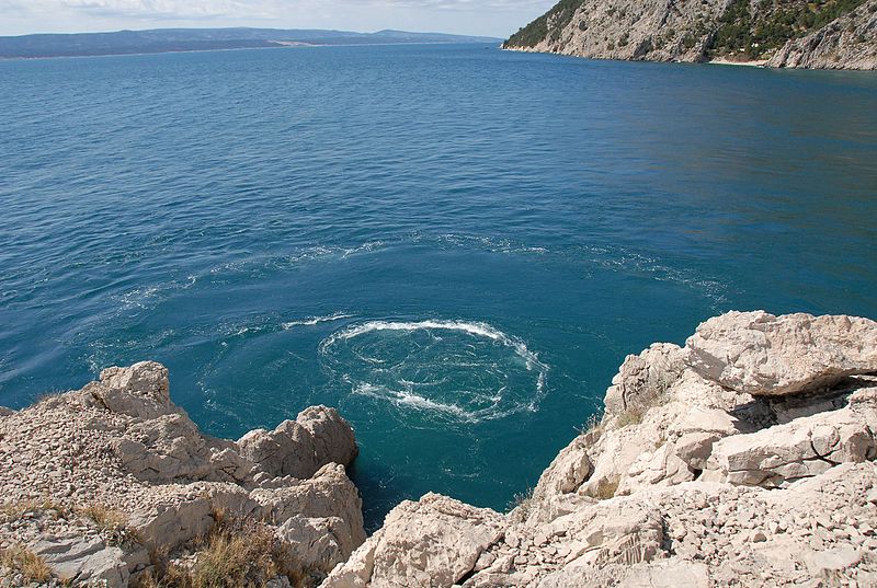
Deutsch: submarine Karstquelle (Vrulja), in der südkroatischen „Vrulja Bay“ bei Brela. Das Süßwasser großer Karstwasser-Gänge strömt unmittelbar an der steilen Felsküste ins Meer. Süßwasser ist leichter (physikalisch weniger dicht) als Salzwasser und steigt – wenn der Wasserdruck stark genug ist – sichtbar bis an die Oberfläche. Je nach Verlauf des Karstwasser-Gangs und je nach Wasserdruck dringt mindestens geringfügig, u.U. auch viel, Salzwasser ein – auch durch tektonische Risse und Klüfte in den Gesteinsschichten. Den Adriaküsten von Slowenien, Kroatien, Montenegro und Albanien liegt das ca. 800 km lange, verkarstete Dinarische Gebirge vor. Daher gibt es an diesen Küsten zahlreiche küstennahe und submarine Quellen. English: Submarine karst spring (“Vrulja”) at the coast of Croatia, north of Brela. As the hydraulic head seems to be strong, the intrusion uprising of the karst conduit’s freshwater is well visible. Depending on more or less intrusion at the outlet, there is Chloride intrusion – at least by tectonic fissures in karstic rocks, which - inevitably -remain in contact with sea water. The Adriatic Sea is flanked by the karstic Dinaric Alps. This is why there are numerous submarine springs along the coastline from Slovenia to Albania. Since late Pleistocene the water table of the Adriatic Sea rose by ca. 120 m. Springs that emerged on the surface became submarine. |
| Date | |
| Source | Own work |
| Author | Rainer Pinhack |
| Permission (Reusing this file) |
explicit permission by E-Mail as of November 8th, 2016 |
Licensing
[edit]
This file is licensed under the Creative Commons Attribution-Share Alike 3.0 Germany license.
- You are free:
- to share – to copy, distribute and transmit the work
- to remix – to adapt the work
- Under the following conditions:
- attribution – You must give appropriate credit, provide a link to the license, and indicate if changes were made. You may do so in any reasonable manner, but not in any way that suggests the licensor endorses you or your use.
- share alike – If you remix, transform, or build upon the material, you must distribute your contributions under the same or compatible license as the original.

File history
Click on a date/time to view the file as it appeared at that time.
| Date/Time | Thumbnail | Dimensions | User | Comment | |
|---|---|---|---|---|---|
| current | 17:03, 16 December 2016 | | 2,896 × 1,944 (3.53 MB) | Ulrichstill (talk | contribs) | User created page with UploadWizard |
You cannot overwrite this file.
File usage on Commons
The following page uses this file:
File usage on other wikis
The following other wikis use this file:
- Usage on de.wikipedia.org
- Usage on sv.wikipedia.org
- Usage on www.wikidata.org